🤿 Conservation Engineering
Important concepts related to measurement of irrigation water
Irrigation Water Conservation Engineering
- Surveying is a process which determines positions of points on the surface of earth, in horizontal distance.

- Objective: to prepare a plan or map
- Uses:
- to prepare road
- to make irrigation channel
- to make channels
- to make railway lines
- in soil conservation etc.
- Soil Surveying helps in getting and collecting information about soils and preparing an inventory of soil resources of an area.
Types of surveying
- Reconnaissance soil survey (RSS):
- Helps to identify benchmark
soilsfor delineating problem and potential areas and providing information useful for making land use plans and agriculture development.
- Helps to identify benchmark
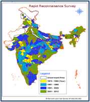
- Scale:
- 1 : 50,000 👉🏻 1cm = 0.5 km (for state and district level survey)
- 1 : 2,50,000 👉🏻 1cm = 2.5 km (for national survey)
- Detailed soil survey (DSS):
- Helps to understand the soil and land problems and for different conservation measures to control soil erosion, to fix irrigation scheduled, in agriculture and watershed development.
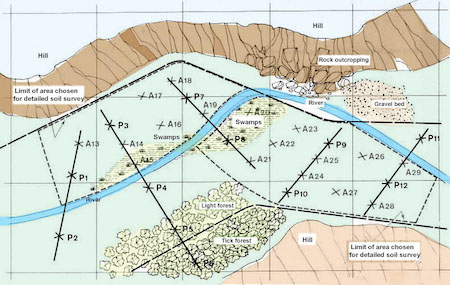
- Scale:
- 1: 8,000 👉🏻 1 cm = 80mm or 0.08km
- 1: 20,000 👉🏻 1cm = 0.2km
- 1: 10,000 👉🏻 for Arial photos
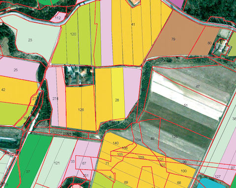
- Cadastral survey (land survey): determines
land boundariesandareas.
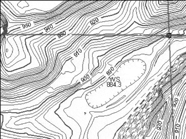
- Topographic survey: determines the shape or
reliefof the ground and the location of various natural and artificial features.
Instruments used in Surveying
A. Instruments Used for Measuring Distance
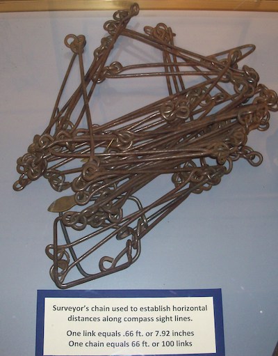
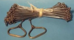
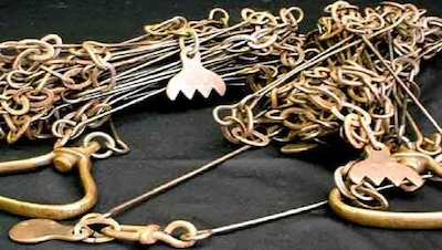
- Chain: The chain is composed of 100 or 150 pieces of galvanized mild steel wire 4 mm in diameter called links.
- Metric chains: The chains are made in lengths of
20 and 30 meters. - Gunter’s Chain: It is
66 feetlong and is divided into 100 links. Each link is 0.66 ft long.
- Metric chains: The chains are made in lengths of
- Revenue Chain: It is
33 feetlong and divided into 16 links. Each link is 2.0625 ft long. It is commonly used for measuring fields in cadastral survey.
- Engineer’s chain: It is
100 feetlong and it is divided into 100 links. Each link is 1 ft in a length. Used in all Engineering surveys.
- Arrows (Chain Pins): Also called as marking or chaining pins and are used to mark the end of chain during the process of chaining. The arrows are made 400 mm in length. They are pointed at one end of inserting in to the ground.
- Tape: Metric, cloth and steel tape.
B. Instruments for marking stations
- Wooden Pegs: These are used to mark the positions.
- Ranging rods: Used for making the position of stations and for ranging.
- Ranging Poles: Used in the case of very long lines.
- Offset Rod: It is used for aligning short offsets.
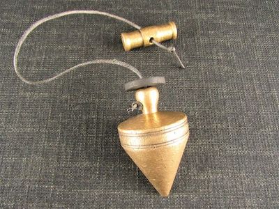
- Plumb Bob: It is also used for testing the verticality of ranging poles.
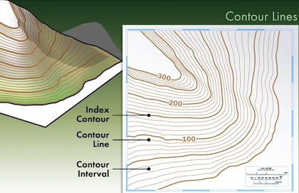
- Contour line: an imaginary line of constant elevation on the surface of the ground.
- Contour interval: the vertical distance between two consecutive contours.
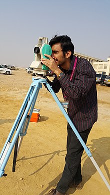
- Theodolite is a device used for measuring horizontal and vertical angles.
- Gross Command Area (G.C.A): Total area which can be irrigated by a certain channel or a project.
- Culturable Command Area (C.C.A): It is the portion of the G.C.A which is Culturable or cultivable.
C.C.A. = G.C.A. - uncultivable area in the G.C.A.
- The common practice in northern India for distribution of water through canal to farmer is
Warabandi(numbers of turns).
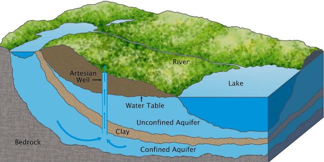
Aquifer
- A porous soil or geological formation which will yield significant quantity of water.
- Unconfined aquifer: is also known as a free, phreatic or non-artesian aquifer, is one overlying an impervious stratum, in which the water is not under pressure.
- Confined aquifers: Also known as artesian or pressure aquifers lie below an impervious layer and the water in them is under pressure.
- Types of pumps for Irrigation
- Displacement pumps (reciprocating pumps and rotary pump): operating pressure (atm pressure i.e. 1 kg/cm2, water lift < 10 m, best result - 7 m).
- Centrifugal pump (suction lift < 4.5 m, Maximum suction head is taken as
6 m, but beyond about 4 m the efficiency of pump drop down substantially. Impeller and casing are two parts of centrifugal pumps. - Turbine pumps (Deep well turbine pumps and submersible pump) - suction lift >7.5 meters.
- Propeller pumps (axial flow and mixed flow) -Suction lift 1 - 2.5 meters.
- Airlift pumps
- Jet pump (suction lift 12 - 18m)
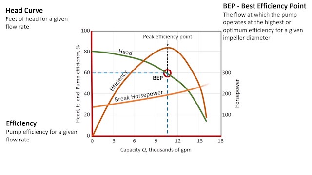
- The interrelationship of
capacity,head,powerandefficiency- are best shown graphically and these curves are called the “characteristics of the pumps”.
Primingis the process of removing air from pump casing and suction pipe by filling water in the suction pipe.
Static Head = Static Suction Head + Static Discharge Head
Total Head = Static Head + Friction Head + Velocity Head
Mesurement of Water
- Water is measured under two conditions: at rest and in motion. Hence, the commonly used in measuring water are in unit flow and unit of volume.
- The commonly used units of water at rest are the litre, cubic meter and hectare - centimeter.
- The commonly used units of water in motion are in m3/s and lit/s.
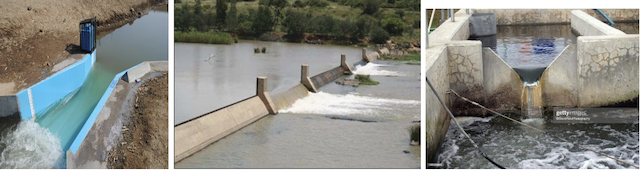
- Orifices, Weirs, Notches and Parshall flumes are used to measure the rates of flow (discharge) of water.
- The basic formula for calculating the discharge through a weirs is
Q = CLHm
- Where,
- C = a coefficient, depending on the nature of the crest and approach conditions
- L = length of crest cm,
- H = head of the crest cm,
- m = exponent depends on the type weir opening
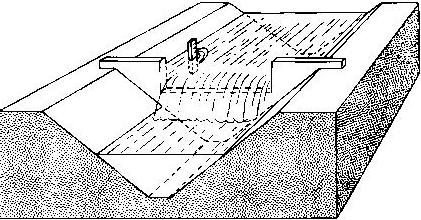
Types of weir based on their shape:
- Rectangular weir: Suppressed Rectangular Weir (
Francis formula):

Q = 0.018
4LH 3/2
- Contracted Rectangular Weir:
Q = 0.0184 (L - 0.1nH) H3/2
- Where, n= numbers of end contractions.
- Cipolletti weir - Trapezoidal weir (slope H:V = 1:4)
Q = 0.018
6LH 3/2
- 90°V notch weir (triangular shape)
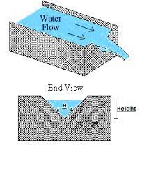
Q = 0.0138 H5/2
- Bernoulli’s theorem is application of the law of conservation of energy to fluid flow.
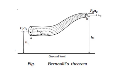
Total Energy (Head) = Pressure Energy (Head) + Velocity Energy (Head) + Elevation Head Energy
- Darcy’s Law is applicable to groundwater flow a K(h — h1) and drainage problems,
V = K(h2 – h1) / L
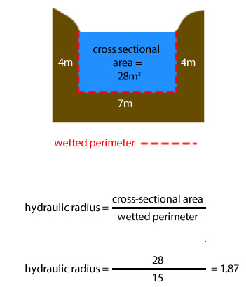
- Hydraulic radius is ratio between the cross-section (a) of the stream and its wetted perimeter (p).
Irrigation Water Conservation Engineering
- Surveying is a process which determines positions of points on the surface of earth, in horizontal distance.
- Objective: to prepare a plan or map
- Uses:
- to prepare road
- to make irrigation channel
- to make channels
- to make railway lines
- in soil conservation etc.
- Soil Surveying helps in getting and collecting information about soils and preparing an inventory of soil resources of an area.
Types of surveying
- Reconnaissance soil survey (RSS):
- Helps to identify benchmark
soilsfor delineating problem and potential areas and providing information useful for making land use plans and agriculture development.
- Helps to identify benchmark
- Scale:
- 1 : 50,000 👉🏻 1cm = 0.5 km (for state and district level survey)
- 1 : 2,50,000 👉🏻 1cm = 2.5 km (for national survey) …
Become Successful With AgriDots
Learn the essential skills for getting a seat in the Exam with
🦄 You are a pro member!
Only use this page if purchasing a gift or enterprise account
Plan
Rs
- Unlimited access to PRO courses
- Quizzes with hand-picked meme prizes
- Invite to private Discord chat
- Free Sticker emailed
Lifetime
Rs
1,499
once
- All PRO-tier benefits
- Single payment, lifetime access
- 4,200 bonus xp points
- Next Level
T-shirt shipped worldwide

Yo! You just found a 20% discount using 👉 EASTEREGG

High-quality fitted cotton shirt produced by Next Level Apparel