📐 Forest Mensuration
Definition & Basic Concepts
- The word mensuration is derived from a Latin word mensura, which means measure.

- Mensuration is traditionally defined as a branch of mathematics dealing with the measurement of lengths of lines, areas of surfaces, and volumes of solids.
- In forestry, it encompasses the determination of dimensions, form, weight, growth, volume, health, and age of trees; individually or collectively.
- Forest Mensuration/Dendrometry is the branch of forestry that deals with the
determination of dimension(e.g., diameter, height, volume, etc.),form,ageandincrementof single tree, stands or whole forests either standing or after felling. - Age classification: The division of a crop according to difference in age.
Objectives of the forest mensuration

- Basis for value estimation for sale of forest produces.
- Basis of management: Sustainable utilization of forest produces requires knowledge of the quantum of timber standing in forest and its annual increment. For carbon trading, forest certification, and making our economy “zero-carbon” based.
- Measurement for research: In forest research experiments, measurements of woods are essential to identify the best treatment and method of management.
- Measurement for planning: The future planning of forest management requires estimating the demand of wood, and other forest products. Forest mensuration supplies essential basic statistical data for this planning.
Breast Height

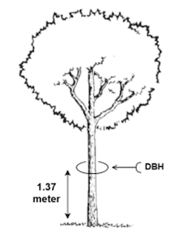
- In case of standing trees, the diameters or girths can be measured at
breast height.
Breast height (BH)is defined as the universally adopted standard height for measuring girth, diameters and basal area of standing trees.- If we take the diameter at this height, which is called diameter at breast height (DBH), and if Girth then called it girth at breast height (GBH).
- In India, the breast height is
1.37 m(4 feet 6 inch) above ground level.

- Basal area: The area of the cross section of a stem at breast height, when applied to a crop, the sum of basal areas of all the stems or the total basal areas per unit area.
Modern Methods
- Electronic measuring devices using laser or ultrasound emissions have become commonly used to measure distances. These devices have reduced the time to measure tree heights considerably and can be used to quickly obtain other tree parameter measures including spatial positions.
- Global Positioning Systems (GPS) that triangulate satellites to determine ground positions have become widely used.
- The word mensuration is derived from a Latin word mensura, which means measure.

- Mensuration is traditionally defined as a branch of mathematics dealing with the measurement of lengths of lines, areas of surfaces, and volumes of solids.
- In forestry, it encompasses the determination of dimensions, form, weight, growth, volume, health, and age of trees; individually or collectively.
- Forest Mensuration/Dendrometry is the branch of forestry that deals with the
determination of dimension(e.g., diameter, height, volume, etc.),form,ageandincrementof single tree, stands or whole forests either standing or after felling. - Age classification: The division of a crop according to difference in age.
Objectives of the forest mensuration

- Basis for value estimation for sale of forest …
Become Successful With AgriDots
Learn the essential skills for getting a seat in the Exam with
🦄 You are a pro member!
Only use this page if purchasing a gift or enterprise account
Plan
Rs
- Unlimited access to PRO courses
- Quizzes with hand-picked meme prizes
- Invite to private Discord chat
- Free Sticker emailed
Lifetime
Rs
1,499
once
- All PRO-tier benefits
- Single payment, lifetime access
- 4,200 bonus xp points
- Next Level
T-shirt shipped worldwide

Yo! You just found a 20% discount using 👉 EASTEREGG

High-quality fitted cotton shirt produced by Next Level Apparel