🏞 Agro-Climatic Zones in India
Classification of Indian territory in Agro-Climatic and Agro-Ecological regions
Agro-Climatic Zones (ACZ):
What is an Agro-Climatic Zone?
It is a land unit uniform in respect of climate and length of growing period (LGP) which is climatically suitable for a certain range of crops and cultivars (FAO, 1983).
What are the factors based on which the classification is done?
- Climatic Factors such as Rainfall, Temperature etc.
- Soil Properties
- Physiographic settings like topography and drainage
- Cropping pattern
- Development of irrigation and mineral resources
👉🏻 Based on these factors The Length of Growing Period (LGP) of crops vary.
👉🏻 LGP refers to the number of days available for crop growth with suitable conditions.
What is the need for such a classification?
- With the diverse climate-soil-crop situations that exist in vast areas of the Indian sub-continent, no single technology or practice satisfies overall planning of agricultural systems.
- Therefore, regional planning based on agro-climatic zones is much relevant to achieve higher crop production.
- Identification of homogeneous agro-climatic zones for regional planning is essential for proper utilization of land, water and other resources through • transfer of suitable technology, • choice of crops, • adoption of uniform policy and • distribution of management inputs Department of Agricultural Research and Education (DARE) of the Indian Council of Agricultural Research (ICAR) also gave much emphasis on agriculture policy and programmes based on agro-climatic zonal approach.
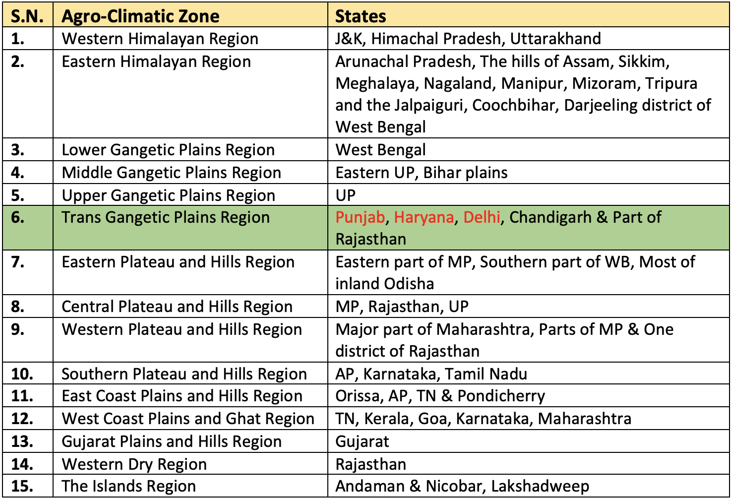
Agro-Climatic Zone Classification by Planning Commission
Planning Commission of India(1988-89) divided country into different agro climatic regions based on homogeneity in rainfall, temperature, topography, cropping and farming systems and water resources.- The principles used for this sub-regionalization related intrinsically with the character of the agricultural economy, namely, soil type, climate, temperature and its variations, rainfall and other agrometeorological characteristics, water demand and supply characteristics including quality of water and aquifer conditions.
- India is divided into
15 agro-climatic regions. - The demarcated agro-climatic zones were not considered adequately homogeneous for the purpose of a detailed operational planning and hence sub-regionalization was carried out.
- The 15 zones were further divided into 73 sub-zones (regions). These sub-zones describe within the state level agro-climatic and socio-economic features.
👉🏻 Following are 15 Agri-Climatic Zones (ACZs) given by Planning Commission:
Western Himalayan Region
- This region covers
Jammu and Kashmir,Himachal PradeshandUttarakhand. - Climate is cool and humid.
- Annual rainfall - 1650-2000 m.
- Soil is predominantly alluvial.
- The valley floors grow rice, while the hilly tracts grow maize in the kharif season.
- Winter crops are barley, oats, and wheat.
- The region supports horticultural crops like apple, peaches, apricot, pears, cherry, Almond, litchis, walnut, etc. Saffron is grown in this region.
- Cropping intensity is lowest in J&K and highest in Himachal Pradesh.
Eastern Himalayan Region
- This region includes
Arunachal Pradesh,the hills of Assam,Sikkim,Meghalaya,Nagaland,Manipur,Mizoram,Tripuraand the Jalpaiguri, Coochbihar, Darjeeling district ofWest Bengal. - Climate is humid and sub humid.
- Annual rainfall - 1840-3528 mm.
- The main crops are rice, maize, potato, tea.
Jhuming(shifting cultivation) prevails in the hilly areas.
Lower Gangetic Plain
- It includes regions in
West Bengal. - Climate is moist humid and dry humid.
- Annual rainfall - 1302-1607 mm.
- Productivity of rice is lower than national average but contributes 12% of total rice production of country.
Riceis the main crop and others are jute, rapeseed, and wheat.
Middle Gangetic Plain
- This region includes
Eastern parts of Uttar PradeshandBiharplains. - It is fertile alluvial plain drained by the Ganga and its tributaries.
- Climate is moist sub humid to dry humid.
- Annual rainfall - 1211-1470 mm.
- 40% of total cropped area is irrigated and cropping intensity is 142% .
- Main crops- Sugarcane, paddy, maize, wheat.
Upper Gangetic Plain
- This region includes the
Western parts of UP. - Climate is dry sub humid to sub dry climate.
- Annual rainfall - 721 — 979 mm.
- It is major
Sugarcanegrowing area. (FCI AGM 2021) - Main crops-rice, wheat, maize and sugarcane.
- Irrigation intensity is 131% and cropping intensity is 145%.
- Milk production and processing units are being established.
Transgangetic Plains
- This region (also called the Satluj-Yamuna plains) extends over
Punjab,Haryana,Chandigarh,Delhiand theGanganagar district of Rajasthan. - Semi-arid characteristics prevail in this region.
- Annual rainfall: 65-125 cm.
Cropping intensity is highest.- Important crops include wheat, sugarcane, cotton, rice, gram, maize, millets, pulses, and oilseeds.
Eastern Plateau and Hills
- This region includes
Eastern Part of MP,Southern Part of West Bengal, Most of inlandOdisha. - Climate is moist sub humid to dry sub humid.
- Annual rainfall is 1271-1436 mm.
- The region is deficient in water resources due to plateau structure and non - perennial streams.
- Important crops are rice, millets, maize, oilseeds, ragi, gram and potato.
- Soils are red and yellow with occasional patches of laterites and alluvium.
Central Plateau and Hills
- The region includes 46 districts of
M.P,U.P. andRajasthan. - Undulating soil topography, ravines are present
- Climate is semi-arid to dry sub humid
- Annual rainfall is 400-1550 mm
- Main crops are wheat, gram, jowar, Bajra, paddy, millets, oilseeds, cotton and sunflower
- Soils are mixed red, yellow and black
- Scarcity of water is major constraint
Western Plateau & Hills
- This region includes major part of
Maharashtra, parts of MP & one district of Rajasthan - It covers maximum parts of peninsular area.
- This is a region of the regur (black soil) NABARD 2021
- Climate is semi-arid
- Annual rainfall-602-1040 mm
- Net sown area-65%, forest area-11%, irrigated area- 12.4%
- Major crops-jowar, bajra, cotton, and wheat
- Irrigation is mainly done by canals
- This region provides 50 % jowar of our country and best quality of orange, grape and banana.
Southern Plateau & Hills
- This region includes the greater parts of
Karnataka,Andhra Pradesh, andTamil Nadu. - It is an area of dry-zone agriculture.
- Annual rainfall - 677-1000mm.
- 81% dry land farming and 111% cropping intensity.
- Major crops- Coffee, tea, cardamom and spices. Suggestions:
- Proper utilization of dry land technology in water shed area.
- Increase fertilizer use efficiency.
- Minor irrigation use programme.
East Coast Plains
- This region includes
Orissa, AP, TN & Pondicherry. - Climate is semi-arid and dry sub humid.
- Annual rainfall: 780-1287mm
- Soils are mainly alluvial and coastal sands are troubled by the problem of alkalinity
- Irrigation through canals and tanks
- Major crops-Rice, Ragi, Jowar & Bajra
- This region contributes 20.3% in total rice production and 17.5% in groundnut production
- 75% area is rainfed
West Coast Plains and Ghats
- This region includes TN,
Kerala, Goa, Karnataka, Maharashtra - Climate is dry sub humid to humid
- Annual rainfall: 2226-3640mm
- The soils are laterite and coastal alluvial
- Main occupation is cultivation of spices and plantation crops which are raised along the hill slopes of western ghats
- Major crops-Rice, Ragi, Groundnut, tapioca
13. Gujarat Plains and Hills
- This region includes 19 districts of
Gujarat - It is an arid and semi-arid region
- Annual rainfall-340-1793 mm
- 32.5% land is irrigated through wells and tube wells
- Main crops-maize, wheat, groundnut, tobacco, cotton, jowar, bajra
- This zone is famous for oilseed crop hence known as oilseed region
- Cropping intensity is 114%
- About 60% area is drought prone
- 78% area is rainfed
- Soils are regur in the plateau region, alluvium in the coastal plains, and red and yellow soils in Jamnagar area
14. Western Dry Region
- This region includes 9 districts of
Rajasthan - This region has an erratic rainfall of an annual average of 95mm
- The desert climate further causes high evaporation
- This region has scanty vegetation and no perennial rivers
- Drought occurs frequently
- Main crops - bajra, gram, wheat, rapeseed
- This region has 1.2% forest area, 4.5% pasture area, 6.3% irrigated area
- Cropping intensity is 105%
15. Island regions
- This region includes
Andaman & NicobarandLakshadweep. - Climate is humid.
- Annual rainfall is 300 mm spread over 8-9 months.
- Largely forest zone with undulating land.
- Main crops are rice, maize, millets, pulses, arecanut, turmeric and cassava.
- Nearly half of the cropped area is under coconut.
👉🏻 Here below is a tabular column that lists down the regions (states) in which the various Agro-Climatic zones lie:
Agro-Climatic Zone Classification by ICAR
- The State Agricultural Universities were advised to divide each state into sub-zones, under the
National Agricultural Research Project (NARP)under ICAR (Indian Council of Agricultural Research) which was launched in1980. - Based on the rainfall pattern, cropping pattern and administrative units,
127 Agro-Climatic Zonesare classified. - The states having maximum number of ACZs are
Madhya PradeshandChattisgarhdivided into 12, followed by Odisha and Karnataka having 10 each.
Agro-Ecological Zones (AEZs)
- The government of India was not satisfied with the classifications done so far.
- It further entrusted
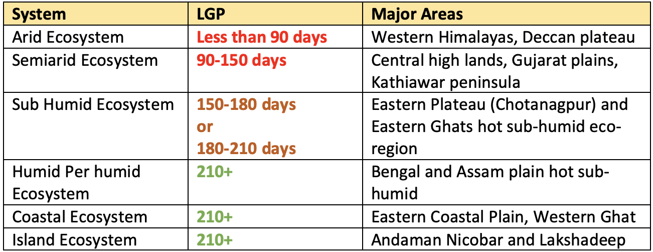
ICARto prepare an agro-ecological region map of the country based on the parameters (rainfall, temperature, vegetation, potential evapo-transpiration) which form the “Bioclimate” and parameters (rainfall, potential evapotranspiration, soil storage) which constitutes the “Length of the Growing Period” (LGP) and parameters (soils and physiography) which form the “Soil or Landscape”. - Physiographic features, soil characteristics, bio-climatic types (rainfall, potential evapotranspiration, soil storage) and length of the growing period, Based on these 4 parameters India is divided into
20 Agro-Ecological Regions. National Bureau of Soil Survey and Land Use Planning (NBSS & LUP)of the ICAR has delineated20 Agro-Ecological Regions (AERs)in the country using the FAO 1978 concept of superimposition of length of growing periods and bio-climate maps on soil physiographic map.- These twenty agro-ecological zones were sub-divided into 60 sub-zones.
✅ Advantages
- The major advantage of LGP based criteria is that the LGP is the direct indicative of moisture availability of a given landform rather than the total rainfall.
- Agro-Ecosystems approach allows crop planning based on length of growing period rather than the quantity of rainfall.
Important Features of the Agro-ecological Zones of India
Agro-Climatic Zones (ACZ):
What is an Agro-Climatic Zone?
It is a land unit uniform in respect of climate and length of growing period (LGP) which is climatically suitable for a certain range of crops and cultivars (FAO, 1983).
What are the factors based on which the classification is done?
- Climatic Factors such as Rainfall, Temperature etc.
- Soil Properties
- Physiographic settings like topography and drainage
- Cropping pattern
- Development of irrigation and mineral resources
👉🏻 Based on these factors The Length of Growing Period (LGP) of crops vary.
👉🏻 LGP refers to the number of days available for crop growth with suitable conditions.
What is the need for such a classification?
- With the diverse climate-soil-crop situations that exist in vast areas of the Indian sub-continent, no single …
Become Successful With AgriDots
Learn the essential skills for getting a seat in the Exam with
🦄 You are a pro member!
Only use this page if purchasing a gift or enterprise account
Plan
- Unlimited access to PRO courses
- Quizzes with hand-picked meme prizes
- Invite to private Discord chat
- Free Sticker emailed
Lifetime
- All PRO-tier benefits
- Single payment, lifetime access
- 4,200 bonus xp points
- Next Level
T-shirt shipped worldwide

Yo! You just found a 20% discount using 👉 EASTEREGG

High-quality fitted cotton shirt produced by Next Level Apparel