💦 Distribution
Hydrologic Cycle, Classification of Water, Irrigation, Water Budget
Distribution of water resources on the planet Earth
The distribution of water resources on the planet Earth: (The figures given below are approximate values)
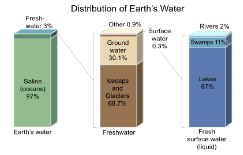
Water in our planet is available in the atmosphere, the oceans, on land and within the soil and fractured rock of the earth’s crust. Water molecules from one location to another are driven by the solar energy. Moisture circulates from the earth into the atmosphere through evaporation and then back into the earth as precipitation. In going through this entire process, which is known as the Hydrologic Cycle, water is conserved i.e., it is neither created nor destroyed.
Hydrologic Cycle
The hydrologic cycle consists of 4 key components:
- Precipitation
- Runoff
- Storage
- Evapotranspiration
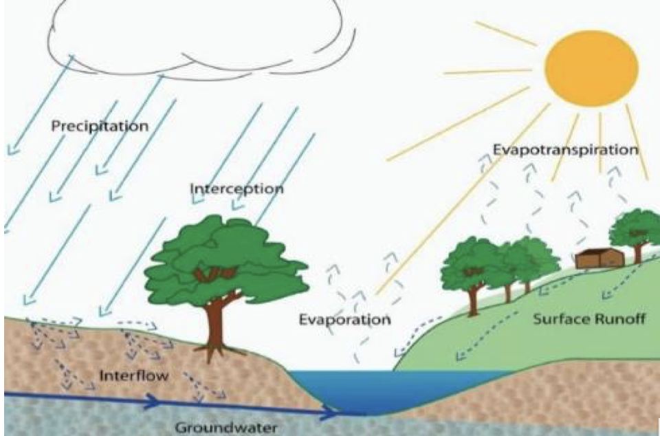
Precipitation
- Precipitation occurs when atmospheric moisture becomes too great to remain suspended in clouds.
- It denotes all forms of water that reach the earth from the atmosphere, the usual forms being rainfall, snowfall, hail, frost and dew.
- Once it reaches the earth’s surface, precipitation can become surface water runoff, surface water storage, glacial ice, water for plants, groundwater, or may evaporate and return immediately to the atmosphere. Ocean evaporation is the greatest source (about 90%) of precipitation.
- Rainfall is the predominant form of precipitation and its distribution over the world and within a country.
Runoff
- Runoff is the water that flows across the land surface after a storm event.
- As the flow bears down, it notches out rills and gullies which combine to form channels. These combine further to form streams and rivers.
- The geographical area which contributes to the flow of a river is called a river or a watershed.
Storage
- Portion of the precipitation falling on land surface which does not flow out as runoff gets stored as either as surface water bodies like- Lakes, Reservoirs and Wetlands or as sub-surface water body, usually called Ground water.
- Ground water storage is the water infiltrating through the soil cover of a land surface and traveling further to reach the huge body of water underground.
- The amount of ground water storage is much greater than that of lakes and rivers.
- However, it is not possible to extract the entire groundwater by practicable means.
- We need to note a point here that the groundwater also is in a state of continuous movement - flowing from regions of higher potential to lower.
- The rate of movement, however, is exceptionally small compared to the surface water movement.
Evapotranspiration
- Evapotranspiration is actually the combination of two terms – evaporation and transpiration.
- The first of these, that is, evaporation is the process of liquid converting into vapour, through wind action and solar radiation and returning to the atmosphere.
- Evaporation is the cause of loss of water from open bodies of water, such as lakes, rivers, the oceans and the land surface.
- Transpiration is the process by which water molecules leaves the body of a living plant and escapes to the atmosphere.
- Evapotranspiration, therefore, includes all evaporation from water and land surfaces, as well as transpiration from plants.
Potential Evapotranspiration
- It is the amount of water evaporated in a unit time from short uniform green crop growing actively and covering an extended surface and never short of water.
- Penman prefers the term potential transpiration.
Classification of Water Resources
👉🏻 The water resources can be divided into two equal parts: Surface Water Resources and Sub Surface Water Resources.
Surface Water Resources
- Surface water is water on the surface of the planet such as in a river, lake, stream, reservoirs, wetland, or ocean.
- It can be contrasted with groundwater and atmospheric water.
- The main uses of surface water include drinking-water and other public uses, irrigation uses, and for use by the thermoelectric-power industry to cool electricity-generating equipment.
Sub-Surface Water Resources
It includes groundwater. Groundwater is an important part of the water cycle.
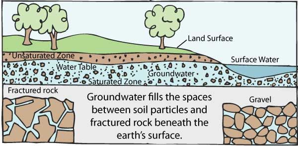
Groundwater
- Groundwater comes from rain and snowmelt that seeps into the ground.
- Gravity pulls the water down through the spaces between particles of soil or through cracks in rocks.
- Eventually the water reaches a depth where all openings in soil or rock are filled with water, this is called the
saturated zone. - The water in the saturated zone is called groundwater.
- The top of the saturated zone is called the
water table. The water table rises and falls according to the season and the amount of rain and snowmelt that has occurred during a particular year. - The bedrock below the saturated zone prevents the water from penetrating more deeply.
Movement of Water
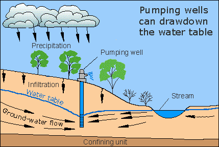
- Different kinds of soil and rock vary in the size of the spaces for water to move through. It is easier for water to move through bigger spaces.
- Gravel has very large spaces so water moves through it very fast. On the other hand, the spaces in clay are so small that almost no water moves through.
- Some layers of rock are so solid that they don’t let water move through; this is called an impermeable layer. Others are very crumbly or have lots of big cracks. If the cracks are connected to each other, then water can move thorough the rock.
Aquifer
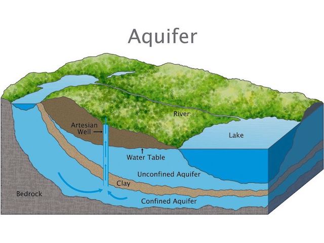
- A saturated soil or rock layer with spaces that allow water to move through is called an aquifer. Aquifers may be separate by layers of rock or clay that do not allow water to move through it.
- Water moves through the pores of the rock. The pores act as a natural filtration system, removing even viruses and bacteria from the water.
- Types of aquifers:
Unconfined Aquifers
- Where groundwater is in
direct contact with the atmospherethrough the open pore spaces of the overlying soil or rock, then the aquifer is said to be unconfined. - The upper groundwater surface in an unconfined aquifer is called the water table.
- The depth of the water table varies according to factors such as the topography, geology, season and tidal effects, and the quantities of water being pumped from the aquifer.
- Unconfined aquifers are usually recharged by rain or stream water infiltrating directly through the overlying soil.
- Typical examples of unconfined aquifers include many areas of coastal sands and alluvial deposits in river valleys.
- An unconfined aquifer’s bottom is a layer of nonporous rock, which restricts water flow, creating a barrier to the aquifer.
- Since the water table is the top layer of the unconfined aquifer, it is because of this reason that it can be also called as
water table aquifers.
Confined Aquifers
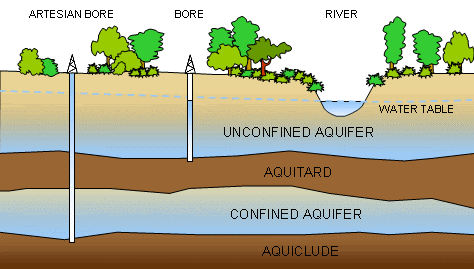
- Confined aquifers are permeable rock units that are usually deeper under the ground than unconfined aquifers.
- They are overlain by relatively impermeable rock or clay that limits groundwater movement into, or out of, the confined aquifer. Thus, a confined aquifer sits below an unconfined aquifer and layer of nonporous rock.
- Groundwater in a confined aquifer is under pressure and will
rise upinside a borehole drilled into the aquifer. - Confined aquifers may be replenished or recharged by rain or stream water infiltrating the rock at some considerable distance away from the confined aquifer. Groundwater in these aquifers can sometimes be thousands of years old.
Functions of water in plants
🙇♂️ We will study about it in Physiology Course - Water Relation.
Water Budget 🛀🏼
- Water budget can be defined as the relationship between the
inflowandoutflowof water through a specified region or a country. - It gives a comparison between the
supplyanddemandof water, making it possible to identify periods of excess and deficit precipitation. - Availability of water depends on various factors such as the water cycle itself, availability of surface water in lakes, rivers, aquifers, wetlands and other water bodies and the usage of water in a region.
- The knowledge of how much water is flowing in and flowing out helps calculate the availability of water at any given time and also helps predict stress in the water budget.
India’s Water Budget
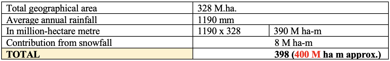
- The rainfall
below 2.5 mmis not considered for water budgeting, since it will immediately evaporate from surface soil without any contribution to surface water or ground water. - There are on an average
130 rainy daysin a year in the country out of which the rain during75 daysconsidered as effective rain. The remaining 55 days are very light and shallow which evaporates immediately without any contribution to surface or ground water recharge. - Considering all these factors it is estimated that out of
400-million-hectare meterof annual rainfall70-million-hectare meteris lost to atmosphere through evaporation and transpiration, about115-million-hectare meterflows as surface run-off and remaining215-million-hectare metersoaks or infiltrates into the soil profile. - Here basically we can see that we are having two components: Input and Output.
- So Input is approximately 400 M ha-m.
Surface Run-off
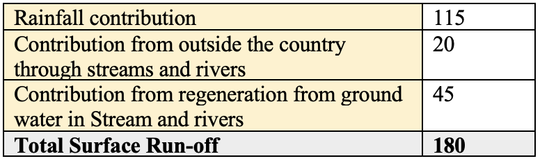
- Surface run off consists of direct run off from rainfall, melting of snowfall and flow in streams generated from ground water.
- Runoff that occurs on surfaces before reaching a channel is also called overland flow.
- A land area which produces runoff draining to a common point is called a watershed.
- When runoff flows along the ground, it can pick up soil contaminants such as pesticides, or fertilizers that become discharge or overland flow.
- Urbanization increases surface runoff, by creating more impervious surfaces such as pavement and buildings do not allow percolation of the water down through the soil to the aquifer.
- It is instead forced directly into streams, where erosion and siltation can be major problems, even when flooding is not.
- Increased runoff reduces groundwater recharge, thus lowering the water table and making droughts worse, especially for farmers and others who depend on water wells.
Total surface run-off has been estimated by Irrigation Commission of India in 1972 as follows:
- Water availability per capita is
2300 m3/year. - Annual water resources in the various river basins is estimated to be about
187 M ha-mand the rechargeable ground water resources is43.2 M ha-m. It means the total water availability in the country is about230 m ha-m.
Explore More 🔭
🟢 River System of India: https://www.youtube.com/watch?v=FUTBseefw2M
Distribution of water resources on the planet Earth
The distribution of water resources on the planet Earth: (The figures given below are approximate values)
Water in our planet is available in the atmosphere, the oceans, on land and within the soil and fractured rock of the earth’s crust. Water molecules from one location to another are driven by the solar energy. Moisture circulates from the earth into the atmosphere through evaporation and then back into the earth as precipitation. In going through this entire process, which is known as the Hydrologic Cycle, water is conserved i.e., it is neither created nor destroyed.
Hydrologic Cycle
The hydrologic cycle consists of 4 key components:
- Precipitation
- Runoff
- Storage
- Evapotranspiration
Precipitation
- Precipitation occurs when …
Become Successful With AgriDots
Learn the essential skills for getting a seat in the Exam with
🦄 You are a pro member!
Only use this page if purchasing a gift or enterprise account
Plan
- Unlimited access to PRO courses
- Quizzes with hand-picked meme prizes
- Invite to private Discord chat
- Free Sticker emailed
Lifetime
- All PRO-tier benefits
- Single payment, lifetime access
- 4,200 bonus xp points
- Next Level
T-shirt shipped worldwide

Yo! You just found a 20% discount using 👉 EASTEREGG

High-quality fitted cotton shirt produced by Next Level Apparel