🦌 India State of Forest Report (ISFR) 2026
ISFR 2026 notes with forest and tree cover, state rankings, bamboo, carbon stock, and exam-ready notes

Measuring India's Green Cover from Space
The full form of ISFR is India State of Forest Report. It is the country's official forest-resource assessment published by the Forest Survey of India (FSI) under the Ministry of Environment, Forest and Climate Change. It is released every two years and is based on remote sensing plus field-based National Forest Inventory inputs.[1][2][3]
If an exam asks for the latest ISFR, the answer here is ISFR 2023, the 18th India State of Forest Report in the series.[1][2][3]
What is ISFR?
| Feature | Detail |
|---|---|
| Full form | India State of Forest Report |
| Latest edition covered here | 18th report in the series (ISFR 2023)[1][2] |
| Published by | Forest Survey of India (FSI) |
| Parent ministry | Ministry of Environment, Forest and Climate Change |
| Frequency | Biennial since 1987 |
| Core method | Satellite digital image processing + visual image analysis + ground verification + National Forest Inventory |
| Why it matters | Tracks forest cover, tree cover, bamboo, carbon stock, mangroves, forest fire indicators, and allied resources |
The report is important for exams because it combines ecology, forestry, climate commitments, and state-wise ranking facts in one place.
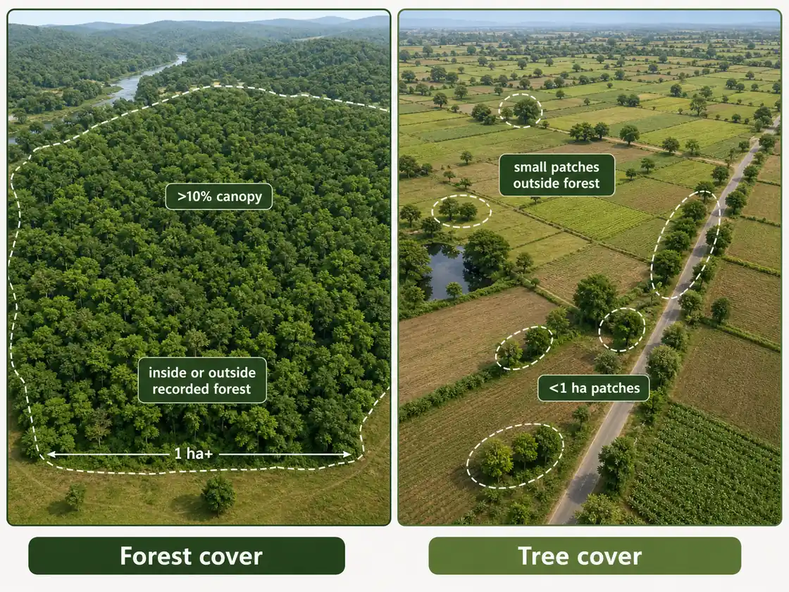
Forest Cover vs Tree Cover
This distinction is still essential even when the report year changes.
| Parameter | Forest Cover | Tree Cover |
|---|---|---|
| Minimum area | More than 1 hectare | Less than 1 hectare |
| Canopy condition | More than 10% canopy density | Trees outside recorded forest in small patches |
| Location | Inside or outside recorded forest | Outside recorded forest only |
| Exam use | Main forest statistic | Completes the broader green-cover picture |
TIP
Exam trap: do not confuse forest cover with forest and tree cover. The second is always larger because it adds tree cover outside forests.
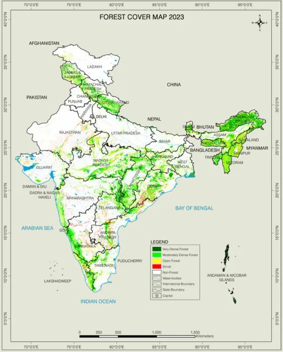
Classification of Forest Cover by Canopy Density
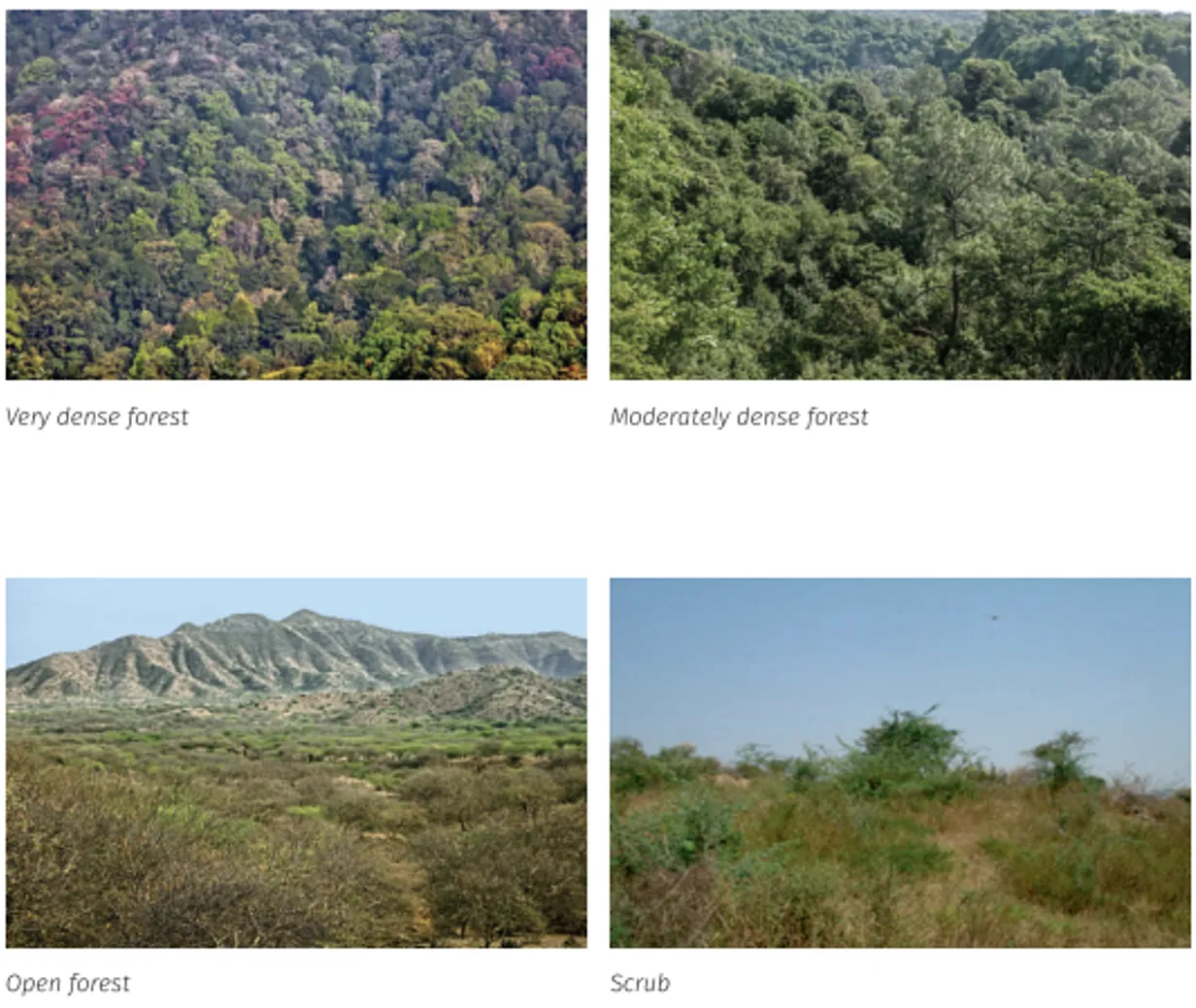
| Class | Canopy Density | Interpretation |
|---|---|---|
| Very Dense Forest (VDF) | Equal to or more than 70% | Highest canopy closure and ecological stability |
| Moderately Dense Forest (MDF) | Equal to or more than 40% but less than 70% | Substantial tree cover |
| Open Forest (OF) | Equal to or more than 10% but less than 40% | Sparse to moderately stocked area |
| Scrub | Canopy density less than 10%, generally with shrubs interspersed with trees | Degraded woody vegetation below forest-cover threshold |
| Non Forest | Not included in VDF, MDF, OF, or Scrub | Includes cropland, settlements, water bodies, grasslands, snow-clad areas, deserts, etc. |
These classes help interpret whether an increase is happening in dense forest, open forest, scrub-to-forest transitions, or mostly in tree cover outside forests.[3]
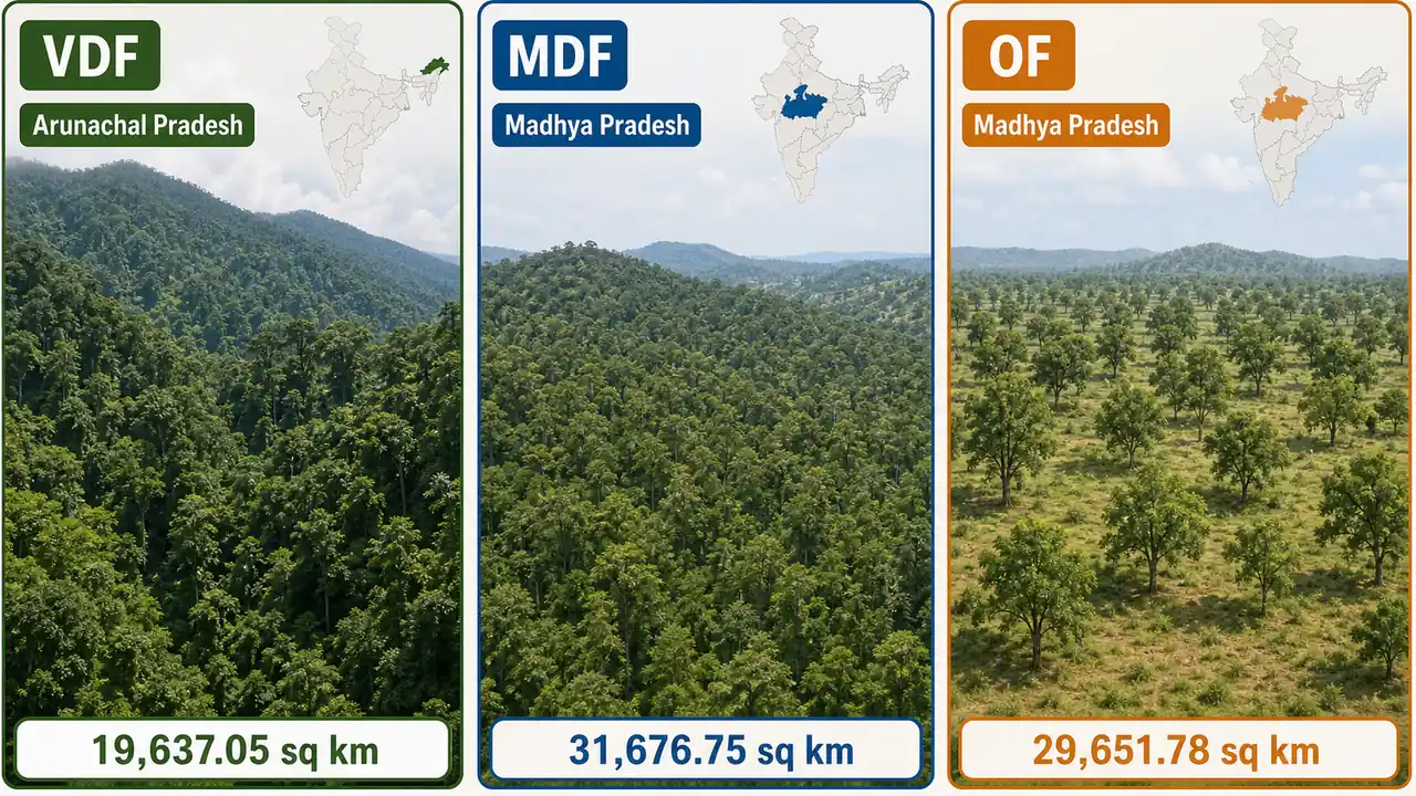
Category-wise state leaders (area basis)
| Forest-cover class | Top state in ISFR 2023 | Area |
|---|---|---|
| Very Dense Forest (VDF) | Arunachal Pradesh | 19,637.05 sq km |
| Moderately Dense Forest (MDF) | Madhya Pradesh | 31,676.75 sq km |
| Open Forest (OF) | Madhya Pradesh | 29,651.78 sq km |
TIP
Fast recall: for VDF, think Arunachal Pradesh. For MDF and OF, think Madhya Pradesh.[3]
Key Findings of ISFR 2023
| Parameter | ISFR 2023 finding |
|---|---|
| Total forest and tree cover | 8,27,356.95 sq km |
| Share of geographical area | 25.17% |
| Forest cover alone | 7,15,342.61 sq km (21.76%) |
| Tree cover alone | 1,12,014.34 sq km (3.41%) |
| Scrub | 43,622.64 sq km (1.33%) |
| Non Forest | 24,16,489.29 sq km (73.50%) |
| Change over 2021 | +1,445.81 sq km in total forest and tree cover |
| Break-up of change | Forest cover +156.41 sq km, tree cover +1,289.40 sq km |
The biggest conceptual takeaway is that the latest gain is driven far more by tree cover growth outside forests than by increase in forest cover itself.[3]
Additional Findings From the PDF
| Topic | Official finding |
|---|---|
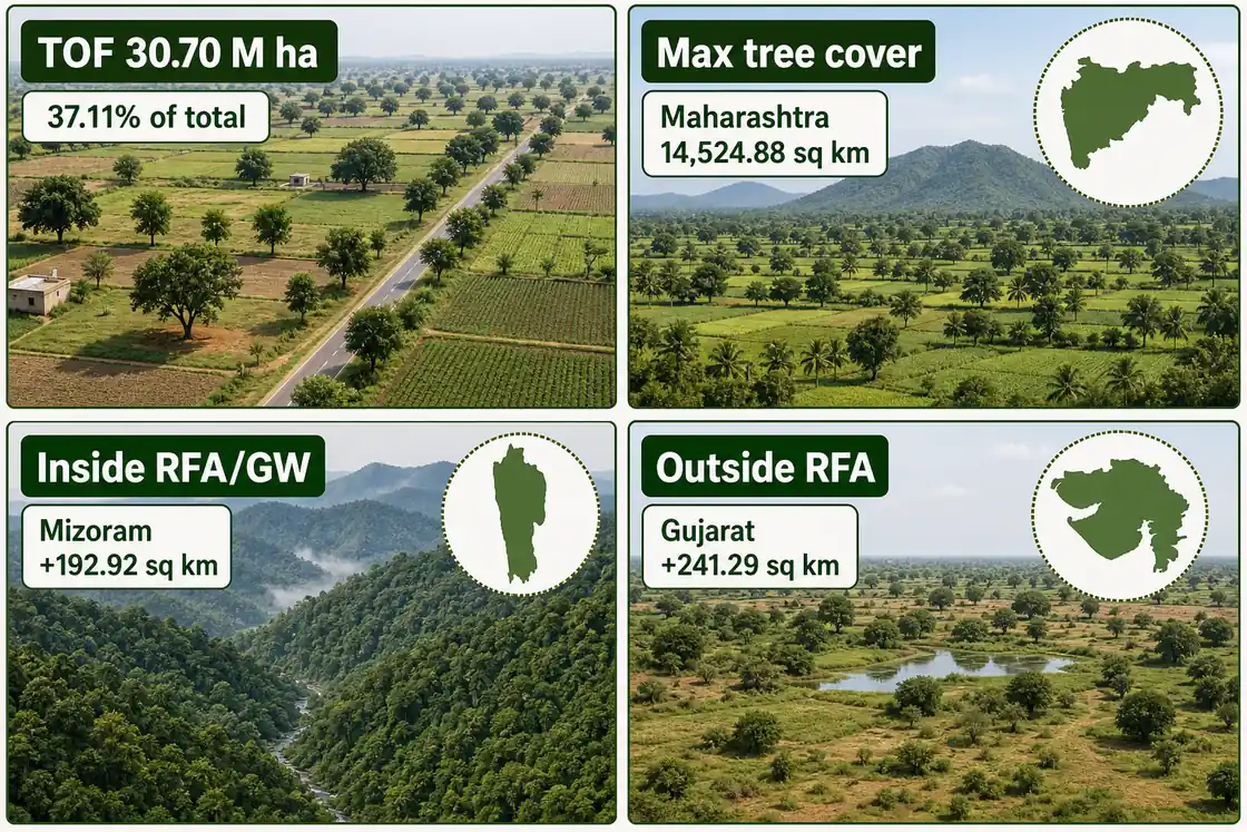
| TOF extent | 30.70 million hectares, which is 37.11% of the country's total forest and tree cover |
| Max tree cover | Maharashtra (14,524.88 sq km), followed by Rajasthan and Uttar Pradesh |
| Forest-cover increase inside RFA/GW | Mizoram (192.92 sq km), Odisha, Karnataka, West Bengal, Jharkhand |
| Forest-cover increase outside RFA | Gujarat (241.29 sq km), Bihar, Kerala, Uttar Pradesh, Assam |
NOTE
RFA/GW means Recorded Forest Area / Green Wash. The PDF separates changes inside RFA/GW from changes outside RFA, which is more precise than a single all-India headline number.[3]
State-wise Rankings and Change
Largest Forest and Tree Cover
| Rank | State | Area |
|---|---|---|
| 1 | Madhya Pradesh | 85,724 sq km |
| 2 | Arunachal Pradesh | 67,083 sq km |
| 3 | Maharashtra | 65,383 sq km |
Largest Forest Cover
| Rank | State | Area |
|---|---|---|
| 1 | Madhya Pradesh | 77,073 sq km |
| 2 | Arunachal Pradesh | 65,882 sq km |
| 3 | Chhattisgarh | 55,812 sq km |
Maximum Increase
| Category | Leaders |
|---|---|
| Increase in forest and tree cover | Chhattisgarh (+683.62 sq km), Uttar Pradesh (+559.19 sq km), Odisha (+558.57 sq km), Rajasthan (+394.46 sq km) |
| Decrease in forest and tree cover | Madhya Pradesh (-612.41 sq km), Karnataka, Ladakh, Nagaland |
| Increase in forest cover inside RFA/GW | Mizoram (+192.92 sq km), Odisha (+118.17 sq km), Karnataka (+93.14 sq km) |
| Increase in forest cover outside RFA | Gujarat (+241.29 sq km), Bihar (+106.85 sq km), Kerala (+95.19 sq km) |
Percentage-wise Leader
Lakshadweep has the highest forest cover as a percentage of geographical area, followed by Mizoram and Andaman & Nicobar Islands.[1]
TIP
Revision cue: for area-based leadership, remember Madhya Pradesh. For percentage-based state leadership, remember Mizoram.
Bamboo and Carbon Stock
Two high-value exam facts from the 2023 report are:
| Topic | ISFR 2023 finding |
|---|---|
| Bamboo-bearing area | 1,54,670 sq km |
| Change in bamboo area over 2021 | +5,227 sq km |
| Total carbon stock in forests | 7,285.5 million tonnes |
| Increase in carbon stock | +81.5 million tonnes |
| Additional carbon sink achieved over 2005 baseline | 2.29 billion tonnes CO2 equivalent |
| India's NDC-linked target by 2030 | 2.5-3.0 billion tonnes CO2 equivalent |
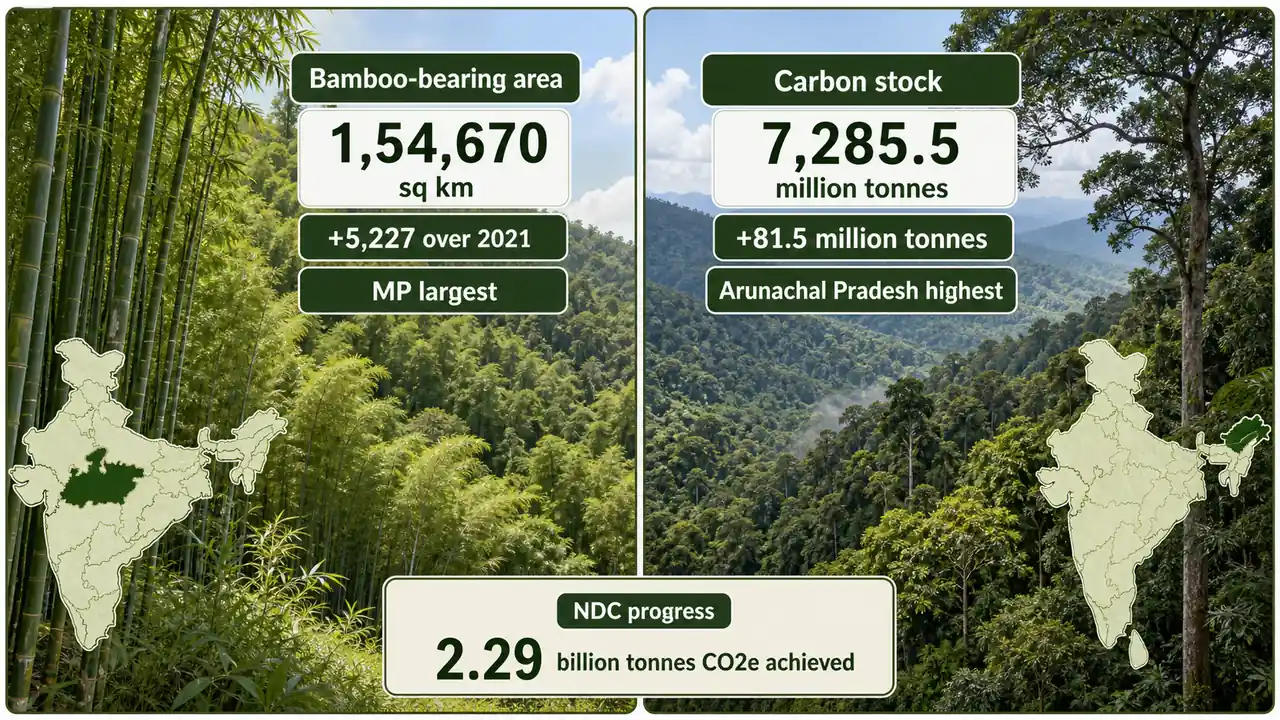
Madhya Pradesh has the largest bamboo-bearing area, while Arunachal Pradesh has the maximum carbon stock among states.[3]
This makes ISFR important not just for forestry exams, but also for climate policy, carbon sink targets, and India's NDC progress.[1]
Summary Cheat Sheet
| Concept / Topic | Key Details |
|---|---|
| ISFR full form | India State of Forest Report |
| Latest edition here | ISFR 2023 = 18th report in the series |
| Published by | Forest Survey of India (FSI) under MoEFCC |
| Frequency | Biennial |
| Core method | Remote sensing + image analysis + ground verification + National Forest Inventory |
| Forest cover | Tree patches more than 1 hectare with more than 10% canopy density |
| Tree cover | Trees outside recorded forest in patches less than 1 hectare |
| Biggest exam trap | Forest cover is not the same as forest and tree cover |
| Canopy classes | VDF: 70%+; MDF: 40% to <70%; OF: 10% to <40%; Scrub: <10% |
| Total forest and tree cover | 8,27,356.95 sq km (25.17%) |
| Forest cover alone | 7,15,342.61 sq km (21.76%) |
| Tree cover alone | 1,12,014.34 sq km (3.41%) |
| Change over 2021 | +1,445.81 sq km total; gain driven more by tree cover than forest cover |
| Largest forest and tree cover | Madhya Pradesh |
| Largest forest cover | Madhya Pradesh |
| Highest percentage cover | Lakshadweep; among states, Mizoram |
| VDF leader | Arunachal Pradesh |
| MDF and OF leader | Madhya Pradesh |
| TOF extent | 30.70 million ha (37.11% of total forest and tree cover) |
| Max tree cover state | Maharashtra |
| Inside RFA/GW gain leader | Mizoram |
| Outside RFA gain leader | Gujarat |
| Bamboo-bearing area | 1,54,670 sq km |
| Change in bamboo area | +5,227 sq km |
| Total carbon stock | 7,285.5 million tonnes |
| Increase in carbon stock | +81.5 million tonnes |
| Additional carbon sink achieved | 2.29 billion tonnes CO2 equivalent |
| 2030 NDC-linked target | 2.5-3.0 billion tonnes CO2 equivalent |
TIP
Fast recall: Arunachal = VDF, Madhya Pradesh = MDF + OF + largest total area, Maharashtra = max tree cover, Mizoram = inside RFA gain, Gujarat = outside RFA gain.
Official Source
3 sources • [1] [2] [3]
Official Source
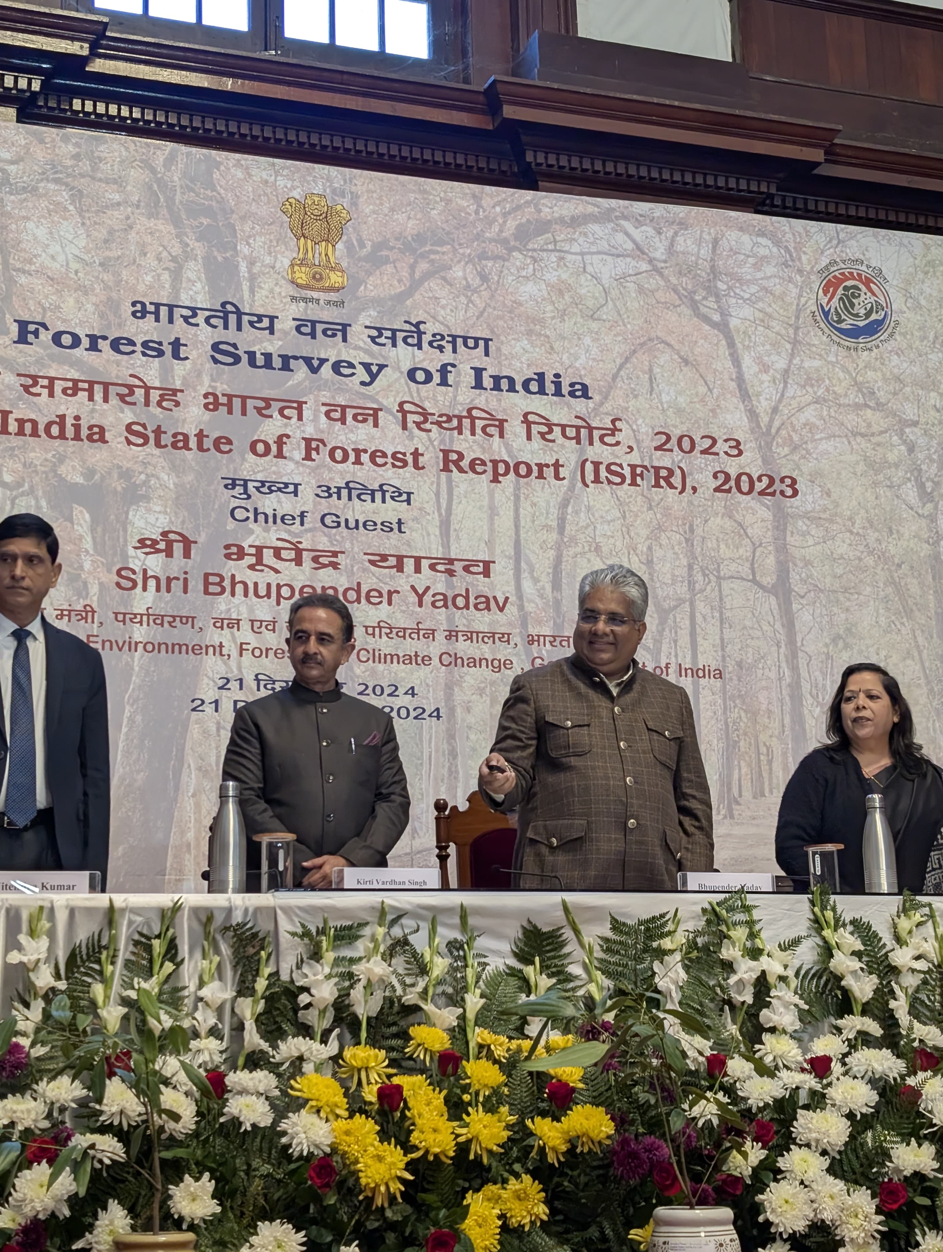
PIB — Union Minister Bhupender Yadav Releases India State of Forest Report 2023 (21 Dec 2024)
OfficialUsed for: PIB press release on ISFR 2023.
Used for: Forest Survey of India report landing page.
Used for: ISFR 2023 Volume I PDF.