🤿Irrigation Water Measurement and Conservation Engineering
Surveying types, chains, weirs, aquifers, pumps, Bernoulli's theorem, Darcy's Law, hydraulic radius — essential concepts for irrigation and drainage
Before a single drop of water reaches a farmer’s field, engineers must survey the land, design channels, measure flow rates, and select the right pump. From Gunter’s chain (66 feet, used since the 17th century) to modern laser-guided levellers, irrigation and conservation engineering provides the infrastructure backbone that makes Indian agriculture possible — and understanding these concepts is essential for NABARD, FCI, and agricultural officer exams.
Irrigation Water Conservation Engineering
- Surveying is a process which determines positions of points on the surface of earth, in horizontal distance. Surveying forms the foundation for all engineering works related to irrigation, drainage, and soil conservation. Without accurate surveys, it is impossible to design and construct irrigation channels, reservoirs, or drainage systems correctly.

-
Objective: to prepare a plan or map that accurately represents the terrain and features of an area. These maps serve as the reference document for all subsequent engineering design and construction activities.
-
Uses:
- to prepare road alignments
- to make irrigation channels
- to make canals
- to make railway lines
- in soil conservation etc.
-
Soil Surveying helps in getting and collecting information about soils and preparing an inventory of soil resources of an area. This inventory guides decisions on land use, irrigation planning, and conservation measures. Knowing the soil type, depth, and drainage characteristics of an area is essential before planning any irrigation or conservation project.
Types of surveying
- Reconnaissance soil survey (RSS):
- Helps to identify benchmark soils for delineating problem and potential areas and providing information useful for making land use plans and agriculture development. RSS gives a broad overview of the soil types in a large region, making it the first step in any new area development.

- Scale:
- 1 : 50,000 — 1cm = 0.5 km (for state and district level survey)
- 1 : 2,50,000 — 1cm = 2.5 km (for national survey)
TIP
Remember: The larger the denominator in the scale, the smaller the detail shown on the map. RSS uses larger denominators because it covers vast areas with less detail.
- Detailed soil survey (DSS):
- Helps to understand the soil and land problems and for different conservation measures to control soil erosion, to fix irrigation schedules, in agriculture and watershed development. DSS provides much more granular information compared to RSS, making it suitable for farm-level planning and implementation of specific conservation practices.

- Scale:
- 1: 8,000 — 1 cm = 80 mm or 0.08 km
- 1: 20,000 — 1 cm = 0.2 km
- 1: 10,000 — for aerial photos
- Cadastral survey (land survey): determines land boundaries and areas. This type of survey is crucial for land ownership records, revenue purposes, and resolving boundary disputes. Cadastral surveys form the legal basis of land records maintained by revenue departments.

- Topographic survey: determines the shape or relief of the ground and the location of various natural and artificial features. Topographic maps show elevations, slopes, and contours, which are essential for designing irrigation and drainage systems. Engineers rely heavily on topographic data when planning canal routes, reservoir sites, and field layouts.
Instruments used in Surveying
A. Instruments Used for Measuring Distance
-
Chain: The chain is composed of 100 or 150 pieces of galvanized mild steel wire 4 mm in diameter called links. Chains are the oldest and most fundamental distance-measuring instruments in surveying.
-
Metric chains: The chains are made in lengths of 20 and 30 meters. These are the standard chains used in modern metric surveying.
-
Gunter’s Chain: It is 66 feet long and is divided into 100 links. Each link is 0.66 ft long. This chain is historically significant as it connects linear measurement to land area — 10 square chains = 1 acre.
-

- Revenue Chain: It is 33 feet long and divided into 16 links. Each link is 2.0625 ft long. It is commonly used for measuring fields in cadastral survey for revenue and land records.

- Engineer’s chain: It is 100 feet long and it is divided into 100 links. Each link is 1 ft in length. Used in all Engineering surveys because its 1-foot link length makes calculations simple and straightforward.

IMPORTANT
Quick recall for chains: Gunter’s = 66 ft (100 links), Revenue = 33 ft (16 links), Engineer’s = 100 ft (100 links). These values are frequently tested in exams.
-
Arrows (Chain Pins): Also called marking or chaining pins and are used to mark the end of chain during the process of chaining. The arrows are made 400 mm in length. They are pointed at one end for inserting into the ground. Arrows help keep track of how many chain lengths have been measured across a distance.
-
Tape: Metric, cloth and steel tape. Steel tapes are the most accurate for precise measurements, while cloth tapes are more flexible and convenient for rough measurements. For high-precision work, invar tapes (made of nickel-iron alloy) are used because they have minimal thermal expansion.
B. Instruments for marking stations
- Wooden Pegs: These are used to mark the positions of survey stations permanently in the ground.
- Ranging rods: Used for marking the position of stations and for ranging (establishing a straight line between two points). They are typically painted in alternating red and white bands for easy visibility.
- Ranging Poles: Used in the case of very long lines where ranging rods are not visible over the distance. Ranging poles are taller and sometimes fitted with flags.
- Offset Rod: It is used for aligning short offsets — perpendicular measurements taken from the main survey line to nearby features.
- Plumb Bob: It is also used for testing the verticality of ranging poles. A plumb bob hangs freely under gravity, providing a true vertical reference. It is especially useful on uneven terrain where the chain must be held horizontally.

-
Contour line: an imaginary line of constant elevation on the surface of the ground. All points on a contour line are at the same height above mean sea level. Contour lines are fundamental for understanding terrain and planning irrigation layouts — closely spaced contour lines indicate steep slopes, while widely spaced lines indicate gentle terrain.
-
Contour interval: the vertical distance between two consecutive contours. A smaller contour interval provides more detailed terrain information but requires more survey work. The choice of contour interval depends on the purpose of the survey and the nature of the terrain.

- Theodolite is a device used for measuring horizontal and vertical angles. It is one of the most precise instruments in surveying, essential for triangulation and establishing control points. Modern electronic theodolites (total stations) can also measure distances simultaneously.

-
Gross Command Area (G.C.A): Total area which can be irrigated by a certain channel or a project. GCA includes both cultivable and non-cultivable land (roads, buildings, barren land) within the boundary of the irrigation project.
-
Culturable Command Area (C.C.A): It is the portion of the G.C.A which is Culturable or cultivable — the land actually suitable for growing crops.
C.C.A. = G.C.A. - uncultivable area in the G.C.A.
NOTE
The difference between GCA and CCA is a commonly tested concept. Always remember: CCA is always less than GCA because it excludes roads, settlements, water bodies, and barren patches within the project area.
- The common practice in northern India for distribution of water through canal to farmer is Warabandi (numbers of turns). Under this system, each farmer receives water for a fixed duration in a rotational schedule, ensuring equitable distribution among all users. The time allotted to each farmer is proportional to the size of their landholding.

Aquifer
-
An aquifer is a porous soil or geological formation which will yield a significant quantity of water. Aquifers are the primary source of groundwater for irrigation wells and tube wells. Not all underground layers contain usable water — only those with sufficient porosity and permeability qualify as aquifers.
-
Unconfined aquifer: is also known as a free, phreatic or non-artesian aquifer, is one overlying an impervious stratum, in which the water is not under pressure. The water table in an unconfined aquifer rises and falls freely with recharge and withdrawal. Most open dug wells tap into unconfined aquifers.
-
Confined aquifers: Also known as artesian or pressure aquifers, lie below an impervious layer and the water in them is under pressure. When a well is drilled into a confined aquifer, water may rise above the aquifer level or even flow to the surface without pumping (artesian well). Confined aquifers are typically deeper and provide more reliable water supply.
-

-
Types of pumps for Irrigation — selecting the right pump depends on the water source depth, required discharge, and available power:
-
Displacement pumps (reciprocating pumps and rotary pump): operating pressure (atm pressure i.e. 1 kg/cm2), water lift < 10 m, best result — 7 m. These pumps use a piston or rotor to physically push water.
-
Centrifugal pump (suction lift < 4.5 m, Maximum suction head is taken as 6 m, but beyond about 4 m the efficiency of pump drops down substantially). Impeller and casing are two main parts of centrifugal pumps. These are the most widely used pumps in agriculture due to their simplicity and reliability.
-
Turbine pumps (Deep well turbine pumps and submersible pump) — suction lift >7.5 meters. These are used for deep bore wells where centrifugal pumps cannot function.
-
Propeller pumps (axial flow and mixed flow) — Suction lift 1 - 2.5 meters. Best suited for moving large volumes of water at low heads, such as in canal irrigation.
-
Airlift pumps — use compressed air to lift water. Simple in construction but less efficient than mechanical pumps.
-
Jet pump (suction lift 12 - 18 m) — combines a centrifugal pump with a jet nozzle to achieve greater suction depth. Useful for medium-depth wells.
-
-
The interrelationship of capacity, head, power and efficiency are best shown graphically and these curves are called the “characteristics of the pumps”. Understanding pump characteristics helps in selecting the right pump for a specific irrigation requirement — the operating point should match the field conditions for maximum efficiency.

- Priming is the process of removing air from pump casing and suction pipe by filling water in the suction pipe. Priming is essential before starting a centrifugal pump — if air remains in the casing, the pump will not be able to create the necessary suction to lift water. Forgetting to prime a centrifugal pump is a common cause of pump failure on farms.
Static Head = Static Suction Head + Static Discharge Head
Total Head = Static Head + Friction Head + Velocity Head
The total head represents the total energy that the pump must impart to the water to move it from the source to the delivery point, accounting for elevation, pipe friction, and water velocity. Always calculate total head before selecting a pump to ensure it can handle the full requirement.
Mesurement of Water
-
Water is measured under two conditions: at rest and in motion. Hence, the commonly used units in measuring water are in unit of flow and unit of volume.
-
The commonly used units of water at rest are the litre, cubic meter and hectare-centimeter. One hectare-centimeter equals 100 cubic meters of water.
-
The commonly used units of water in motion are in m3/s and lit/s. These units express the rate of flow or discharge.
-
Orifices, Weirs, Notches and Parshall flumes are used to measure the rates of flow (discharge) of water. Each structure is suited for different channel sizes and flow conditions — weirs are common for open channels, while Parshall flumes are preferred where minimal head loss is required.

- The basic formula for calculating the discharge through a weir is
Q = CLHm
- Where,
- C = a coefficient, depending on the nature of the crest and approach conditions
- L = length of crest (cm)
- H = head over the crest (cm) — the height of water above the weir crest
- m = exponent depends on the type of weir opening
TIP
The weir discharge formula is the foundation for all specific weir equations below. The values of C and m change based on weir shape, but the basic structure remains the same.
Types of weir based on their shape:
- Rectangular weir: Suppressed Rectangular Weir (Francis formula). In a suppressed weir, the width of the weir equals the width of the channel, so there are no end contractions.

Q = 0.0184 LH 3/2
- Contracted Rectangular Weir: In this type, the weir width is less than the channel width, causing the water to contract at the ends. The effective length is reduced due to end contractions.

Q = 0.0184 (L - 0.1nH) H3/2
- Where, n = numbers of end contractions. This correction factor accounts for the reduced effective length due to flow contraction at the weir edges. For a fully contracted weir, n = 2 (both ends).
- Cipolletti weir — a Trapezoidal weir (slope H:V = 1:4). The trapezoidal shape compensates for the end contractions, so no correction factor is needed in the discharge formula. This makes the Cipolletti weir very practical for field measurements.
Q = 0.0186 LH 3/2
NOTE
Notice the slight difference in coefficients: Rectangular = 0.0184, Cipolletti = 0.0186. This small difference is important for exam calculations.
- 90 degree V notch weir (triangular shape) — particularly accurate for measuring small discharges because even low flows create a measurable head. The V-shape concentrates the flow, making the head reading more sensitive to changes in discharge.

Q = 0.0138 H5/2
- Bernoulli’s theorem is the application of the law of conservation of energy to fluid flow. It states that for an ideal, incompressible fluid flowing in a streamline, the total energy at any point remains constant.

Total Energy (Head) = Pressure Energy (Head) + Velocity Energy (Head) + Elevation Head Energy
This principle is fundamental in hydraulics and is used to analyze flow through pipes, channels, and measuring devices. It explains why water speeds up when a pipe narrows (pressure drops, velocity increases) and vice versa.
- Darcy’s Law is applicable to groundwater flow and drainage problems. It describes the flow of water through porous media (like soil or rock) and states that the flow rate is proportional to the hydraulic gradient.
V = K(h2 - h1) / L
Where K is the hydraulic conductivity of the soil (a measure of how easily water moves through it), (h2 - h1) is the difference in hydraulic head, and L is the length of the flow path. Sandy soils have high K values (water flows easily), while clayey soils have very low K values.
- Hydraulic radius is the ratio between the cross-section (a) of the stream and its wetted perimeter (p). It is a key parameter in open channel flow calculations. A larger hydraulic radius indicates a more efficient channel cross-section that carries more water with less friction. Among all channel shapes, a semicircular cross-section has the highest hydraulic radius for a given area.

Summary Cheat Sheet
| Concept / Topic | Key Details |
|---|---|
| Surveying | Determines positions of points on earth in horizontal distance |
| RSS scale (state) | 1:50,000 (1 cm = 0.5 km); National: 1:2,50,000 |
| DSS scale | 1:8,000 to 1:20,000; aerial photos: 1:10,000 |
| Cadastral survey | Determines land boundaries and areas (revenue purposes) |
| Topographic survey | Determines shape/relief of ground and features |
| Gunter’s chain | 66 feet, 100 links; each link 0.66 ft |
| Revenue chain | 33 feet, 16 links; each link 2.0625 ft |
| Engineer’s chain | 100 feet, 100 links; each link 1 ft |
| Contour line | Imaginary line of constant elevation |
| Theodolite | Measures horizontal and vertical angles |
| GCA | Total area irrigable by a channel (cultivable + non-cultivable) |
| CCA | GCA minus uncultivable area (actual cropping area) |
| Warabandi | Rotational water distribution system (N. India) |
| Unconfined aquifer | Free/phreatic; water not under pressure |
| Confined aquifer | Artesian; water under pressure below impervious layer |
| Centrifugal pump | Max suction lift 4.5 m (practical), 6 m (theoretical) |
| Jet pump | Suction lift 12-18 m |
| Turbine pump | Suction lift > 7.5 m (deep wells) |
| Priming | Removing air from pump casing by filling water |
| Rectangular weir | Q = 0.0184 LH^(3/2) (Francis formula) |
| Cipolletti weir | Trapezoidal (H:V = 1:4); Q = 0.0186 LH^(3/2) |
| 90° V-notch weir | Q = 0.0138 H^(5/2); best for small discharges |
| Bernoulli’s theorem | Conservation of energy in fluid flow |
| Darcy’s Law | V = K(h₂-h₁)/L; for groundwater flow |
| Hydraulic radius | Cross-section area / wetted perimeter |
Pro Content Locked
Upgrade to Pro to access this lesson and all other premium content.
₹2388 billed yearly
- All Agriculture & Banking Courses
- AI Lesson Questions (100/day)
- AI Doubt Solver (50/day)
- Glows & Grows Feedback (30/day)
- AI Section Quiz (20/day)
- 22-Language Translation (30/day)
- Recall Questions (20/day)
- AI Quiz (15/day)
- AI Quiz Paper Analysis
- AI Step-by-Step Explanations
- Spaced Repetition Recall (FSRS)
- AI Tutor
- Immersive Text Questions
- Audio Lessons — Hindi & English
- Mock Tests & Previous Year Papers
- Summary & Mind Maps
- XP, Levels, Leaderboard & Badges
- Generate New Classrooms
- Voice AI Teacher (AgriDots Live)
- AI Revision Assistant
- Knowledge Gap Analysis
- Interactive Revision (LangGraph)
🔒 Secure via Razorpay · Cancel anytime · No hidden fees
Before a single drop of water reaches a farmer’s field, engineers must survey the land, design channels, measure flow rates, and select the right pump. From Gunter’s chain (66 feet, used since the 17th century) to modern laser-guided levellers, irrigation and conservation engineering provides the infrastructure backbone that makes Indian agriculture possible — and understanding these concepts is essential for NABARD, FCI, and agricultural officer exams.
Irrigation Water Conservation Engineering
- Surveying is a process which determines positions of points on the surface of earth, in horizontal distance. Surveying forms the foundation for all engineering works related to irrigation, drainage, and soil conservation. Without accurate surveys, it is impossible to design and construct irrigation channels, reservoirs, or drainage systems correctly.
-
Objective: to prepare a plan or map that accurately represents the terrain and features of an area. These maps serve as the reference document for all subsequent engineering design and construction activities.
-
Uses:
- to prepare road alignments
- to make irrigation channels
- to make canals
- to make railway lines
- in soil conservation etc.
-
Soil Surveying helps in getting and collecting information about soils and preparing an inventory of soil resources of an area. This inventory guides decisions on land use, irrigation planning, and conservation measures. Knowing the soil type, depth, and drainage characteristics of an area is essential before planning any irrigation or conservation project.
Types of surveying
- Reconnaissance soil survey (RSS):
- Helps to identify benchmark soils for delineating problem and potential areas and providing information useful for making land use plans and agriculture development. RSS gives a broad overview of the soil types in a large region, making it the first step in any new area development.
- Scale:
- 1 : 50,000 — 1cm = 0.5 km (for state and district level survey)
- 1 : 2,50,000 — 1cm = 2.5 km (for national survey)
TIP
Remember: The larger the denominator in the scale, the smaller the detail shown on the map. RSS uses larger denominators because it covers vast areas with less detail.
- Detailed soil survey (DSS):
- Helps to understand the soil and land problems and for different conservation measures to control soil erosion, to fix irrigation schedules, in agriculture and watershed development. DSS provides much more granular information compared to RSS, making it suitable for farm-level planning and implementation of specific conservation practices.
- Scale:
- 1: 8,000 — 1 cm = 80 mm or 0.08 km
- 1: 20,000 — 1 cm = 0.2 km
- 1: 10,000 — for aerial photos
- Cadastral survey (land survey): determines land boundaries and areas. This type of survey is crucial for land ownership records, revenue purposes, and resolving boundary disputes. Cadastral surveys form the legal basis of land records maintained by revenue departments.
- Topographic survey: determines the shape or relief of the ground and the location of various natural and artificial features. Topographic maps show elevations, slopes, and contours, which are essential for designing irrigation and drainage systems. Engineers rely heavily on topographic data when planning canal routes, reservoir sites, and field layouts.
Instruments used in Surveying
A. Instruments Used for Measuring Distance
-
Chain: The chain is composed of 100 or 150 pieces of galvanized mild steel wire 4 mm in diameter called links. Chains are the oldest and most fundamental distance-measuring instruments in surveying.
-
Metric chains: The chains are made in lengths of 20 and 30 meters. These are the standard chains used in modern metric surveying.
-
Gunter’s Chain: It is 66 feet long and is divided into 100 links. Each link is 0.66 ft long. This chain is historically significant as it connects linear measurement to land area — 10 square chains = 1 acre.
-
- Revenue Chain: It is 33 feet long and divided into 16 links. Each link is 2.0625 ft long. It is commonly used for measuring fields in cadastral survey for revenue and land records.
- Engineer’s chain: It is 100 feet long and it is divided into 100 links. Each link is 1 ft in length. Used in all Engineering surveys because its 1-foot link length makes calculations simple and straightforward.
IMPORTANT
Quick recall for chains: Gunter’s = 66 ft (100 links), Revenue = 33 ft (16 links), Engineer’s = 100 ft (100 links). These values are frequently tested in exams.
-
Arrows (Chain Pins): Also called marking or chaining pins and are used to mark the end of chain during the process of chaining. The arrows are made 400 mm in length. They are pointed at one end for inserting into the ground. Arrows help keep track of how many chain lengths have been measured across a distance.
-
Tape: Metric, cloth and steel tape. Steel tapes are the most accurate for precise measurements, while cloth tapes are more flexible and convenient for rough measurements. For high-precision work, invar tapes (made of nickel-iron alloy) are used because they have minimal thermal expansion.
B. Instruments for marking stations
- Wooden Pegs: These are used to mark the positions of survey stations permanently in the ground.
- Ranging rods: Used for marking the position of stations and for ranging (establishing a straight line between two points). They are typically painted in alternating red and white bands for easy visibility.
- Ranging Poles: Used in the case of very long lines where ranging rods are not visible over the distance. Ranging poles are taller and sometimes fitted with flags.
- Offset Rod: It is used for aligning short offsets — perpendicular measurements taken from the main survey line to nearby features.
- Plumb Bob: It is also used for testing the verticality of ranging poles. A plumb bob hangs freely under gravity, providing a true vertical reference. It is especially useful on uneven terrain where the chain must be held horizontally.
-
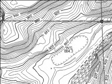
Contour line: an imaginary line of constant elevation on the surface of the ground. All points on a contour line are at the same height above mean sea level. Contour lines are fundamental for understanding terrain and planning irrigation layouts — closely spaced contour lines indicate steep slopes, while widely spaced lines indicate gentle terrain.
-
Contour interval: the vertical distance between two consecutive contours. A smaller contour interval provides more detailed terrain information but requires more survey work. The choice of contour interval depends on the purpose of the survey and the nature of the terrain.
- Theodolite is a device used for measuring horizontal and vertical angles. It is one of the most precise instruments in surveying, essential for triangulation and establishing control points. Modern electronic theodolites (total stations) can also measure distances simultaneously.
-
Gross Command Area (G.C.A): Total area which can be irrigated by a certain channel or a project. GCA includes both cultivable and non-cultivable land (roads, buildings, barren land) within the boundary of the irrigation project.
-
Culturable Command Area (C.C.A): It is the portion of the G.C.A which is Culturable or cultivable — the land actually suitable for growing crops.
C.C.A. = G.C.A. - uncultivable area in the G.C.A.
NOTE
The difference between GCA and CCA is a commonly tested concept. Always remember: CCA is always less than GCA because it excludes roads, settlements, water bodies, and barren patches within the project area.
- The common practice in northern India for distribution of water through canal to farmer is Warabandi (numbers of turns). Under this system, each farmer receives water for a fixed duration in a rotational schedule, ensuring equitable distribution among all users. The time allotted to each farmer is proportional to the size of their landholding.
Aquifer
-
An aquifer is a porous soil or geological formation which will yield a significant quantity of water. Aquifers are the primary source of groundwater for irrigation wells and tube wells. Not all underground layers contain usable water — only those with sufficient porosity and permeability qualify as aquifers.
-
Unconfined aquifer: is also known as a free, phreatic or non-artesian aquifer, is one overlying an impervious stratum, in which the water is not under pressure. The water table in an unconfined aquifer rises and falls freely with recharge and withdrawal. Most open dug wells tap into unconfined aquifers.
-
Confined aquifers: Also known as artesian or pressure aquifers, lie below an impervious layer and the water in them is under pressure. When a well is drilled into a confined aquifer, water may rise above the aquifer level or even flow to the surface without pumping (artesian well). Confined aquifers are typically deeper and provide more reliable water supply.
-
-
Types of pumps for Irrigation — selecting the right pump depends on the water source depth, required discharge, and available power:
-
Displacement pumps (reciprocating pumps and rotary pump): operating pressure (atm pressure i.e. 1 kg/cm2), water lift < 10 m, best result — 7 m. These pumps use a piston or rotor to physically push water.
-
Centrifugal pump (suction lift < 4.5 m, Maximum suction head is taken as 6 m, but beyond about 4 m the efficiency of pump drops down substantially). Impeller and casing are two main parts of centrifugal pumps. These are the most widely used pumps in agriculture due to their simplicity and reliability.
-
Turbine pumps (Deep well turbine pumps and submersible pump) — suction lift >7.5 meters. These are used for deep bore wells where centrifugal pumps cannot function.
-
Propeller pumps (axial flow and mixed flow) — Suction lift 1 - 2.5 meters. Best suited for moving large volumes of water at low heads, such as in canal irrigation.
-
Airlift pumps — use compressed air to lift water. Simple in construction but less efficient than mechanical pumps.
-
Jet pump (suction lift 12 - 18 m) — combines a centrifugal pump with a jet nozzle to achieve greater suction depth. Useful for medium-depth wells.
-
-
The interrelationship of capacity, head, power and efficiency are best shown graphically and these curves are called the “characteristics of the pumps”. Understanding pump characteristics helps in selecting the right pump for a specific irrigation requirement — the operating point should match the field conditions for maximum efficiency.
- Priming is the process of removing air from pump casing and suction pipe by filling water in the suction pipe. Priming is essential before starting a centrifugal pump — if air remains in the casing, the pump will not be able to create the necessary suction to lift water. Forgetting to prime a centrifugal pump is a common cause of pump failure on farms.
Static Head = Static Suction Head + Static Discharge Head
Total Head = Static Head + Friction Head + Velocity Head
The total head represents the total energy that the pump must impart to the water to move it from the source to the delivery point, accounting for elevation, pipe friction, and water velocity. Always calculate total head before selecting a pump to ensure it can handle the full requirement.
Mesurement of Water
-
Water is measured under two conditions: at rest and in motion. Hence, the commonly used units in measuring water are in unit of flow and unit of volume.
-
The commonly used units of water at rest are the litre, cubic meter and hectare-centimeter. One hectare-centimeter equals 100 cubic meters of water.
-
The commonly used units of water in motion are in m3/s and lit/s. These units express the rate of flow or discharge.
-
Orifices, Weirs, Notches and Parshall flumes are used to measure the rates of flow (discharge) of water. Each structure is suited for different channel sizes and flow conditions — weirs are common for open channels, while Parshall flumes are preferred where minimal head loss is required.
- The basic formula for calculating the discharge through a weir is
Q = CLHm
- Where,
- C = a coefficient, depending on the nature of the crest and approach conditions
- L = length of crest (cm)
- H = head over the crest (cm) — the height of water above the weir crest
- m = exponent depends on the type of weir opening
TIP
The weir discharge formula is the foundation for all specific weir equations below. The values of C and m change based on weir shape, but the basic structure remains the same.
Types of weir based on their shape:
- Rectangular weir: Suppressed Rectangular Weir (Francis formula). In a suppressed weir, the width of the weir equals the width of the channel, so there are no end contractions.
Q = 0.0184 LH 3/2
- Contracted Rectangular Weir: In this type, the weir width is less than the channel width, causing the water to contract at the ends. The effective length is reduced due to end contractions.
Q = 0.0184 (L - 0.1nH) H3/2
- Where, n = numbers of end contractions. This correction factor accounts for the reduced effective length due to flow contraction at the weir edges. For a fully contracted weir, n = 2 (both ends).
- Cipolletti weir — a Trapezoidal weir (slope H:V = 1:4). The trapezoidal shape compensates for the end contractions, so no correction factor is needed in the discharge formula. This makes the Cipolletti weir very practical for field measurements.
Q = 0.0186 LH 3/2
NOTE
Notice the slight difference in coefficients: Rectangular = 0.0184, Cipolletti = 0.0186. This small difference is important for exam calculations.
- 90 degree V notch weir (triangular shape) — particularly accurate for measuring small discharges because even low flows create a measurable head. The V-shape concentrates the flow, making the head reading more sensitive to changes in discharge.
Q = 0.0138 H5/2
- Bernoulli’s theorem is the application of the law of conservation of energy to fluid flow. It states that for an ideal, incompressible fluid flowing in a streamline, the total energy at any point remains constant.
Total Energy (Head) = Pressure Energy (Head) + Velocity Energy (Head) + Elevation Head Energy
This principle is fundamental in hydraulics and is used to analyze flow through pipes, channels, and measuring devices. It explains why water speeds up when a pipe narrows (pressure drops, velocity increases) and vice versa.
- Darcy’s Law is applicable to groundwater flow and drainage problems. It describes the flow of water through porous media (like soil or rock) and states that the flow rate is proportional to the hydraulic gradient.
V = K(h2 - h1) / L
Where K is the hydraulic conductivity of the soil (a measure of how easily water moves through it), (h2 - h1) is the difference in hydraulic head, and L is the length of the flow path. Sandy soils have high K values (water flows easily), while clayey soils have very low K values.
- Hydraulic radius is the ratio between the cross-section (a) of the stream and its wetted perimeter (p). It is a key parameter in open channel flow calculations. A larger hydraulic radius indicates a more efficient channel cross-section that carries more water with less friction. Among all channel shapes, a semicircular cross-section has the highest hydraulic radius for a given area.
Summary Cheat Sheet
| Concept / Topic | Key Details |
|---|---|
| Surveying | Determines positions of points on earth in horizontal distance |
| RSS scale (state) | 1:50,000 (1 cm = 0.5 km); National: 1:2,50,000 |
| DSS scale | 1:8,000 to 1:20,000; aerial photos: 1:10,000 |
| Cadastral survey | Determines land boundaries and areas (revenue purposes) |
| Topographic survey | Determines shape/relief of ground and features |
| Gunter’s chain | 66 feet, 100 links; each link 0.66 ft |
| Revenue chain | 33 feet, 16 links; each link 2.0625 ft |
| Engineer’s chain | 100 feet, 100 links; each link 1 ft |
| Contour line | Imaginary line of constant elevation |
| Theodolite | Measures horizontal and vertical angles |
| GCA | Total area irrigable by a channel (cultivable + non-cultivable) |
| CCA | GCA minus uncultivable area (actual cropping area) |
| Warabandi | Rotational water distribution system (N. India) |
| Unconfined aquifer | Free/phreatic; water not under pressure |
| Confined aquifer | Artesian; water under pressure below impervious layer |
| Centrifugal pump | Max suction lift 4.5 m (practical), 6 m (theoretical) |
| Jet pump | Suction lift 12-18 m |
| Turbine pump | Suction lift > 7.5 m (deep wells) |
| Priming | Removing air from pump casing by filling water |
| Rectangular weir | Q = 0.0184 LH^(3/2) (Francis formula) |
| Cipolletti weir | Trapezoidal (H:V = 1:4); Q = 0.0186 LH^(3/2) |
| 90° V-notch weir | Q = 0.0138 H^(5/2); best for small discharges |
| Bernoulli’s theorem | Conservation of energy in fluid flow |
| Darcy’s Law | V = K(h₂-h₁)/L; for groundwater flow |
| Hydraulic radius | Cross-section area / wetted perimeter |
Knowledge Check
Take a dynamically generated quiz based on the material you just read to test your understanding and get personalized feedback.
Lesson Doubts
Ask questions, get expert answers