🛶 Yamuna & Rivers of Western UP
Yamuna river system, Chambal, Hindon, Betwa, Sindh — rivers of western Uttar Pradesh, their course, tributaries, pollution crisis, and exam-relevant facts for Uttar Pradesh GK.
The Yamuna in Uttar Pradesh
The Yamuna is the longest tributary of the Ganga and one of the most important rivers affecting western and southern Uttar Pradesh. It forms the western side of the Ganga-Yamuna Doab and receives several important tributaries from the plateau and ravine region to the south.
For exam memory, this lesson works best if you remember one central pattern:
the Ganga system in eastern and central UP is plain-dominated, while the Yamuna system in western and southern UP is shaped much more by right-bank tributaries, ravines, pollution stress, and plateau-fed rivers.
Yamuna — Key Facts
| Parameter | Detail |
|---|---|
| Origin | Yamunotri glacier, Uttarakhand (at ~6,387 m) |
| Touches / enters the UP region at | Saharanpur-Shamli side after descending from Uttarakhand and flowing along the Haryana-UP side |
| Meets Ganga at | Prayagraj (Triveni Sangam) |
| Total length | ~1,376 km |
| Length associated with UP | ~580 km (approx.) |
| Major UP centres linked with the Yamuna | Mathura, Agra, Etawah, Hamirpur, Prayagraj, Noida region |
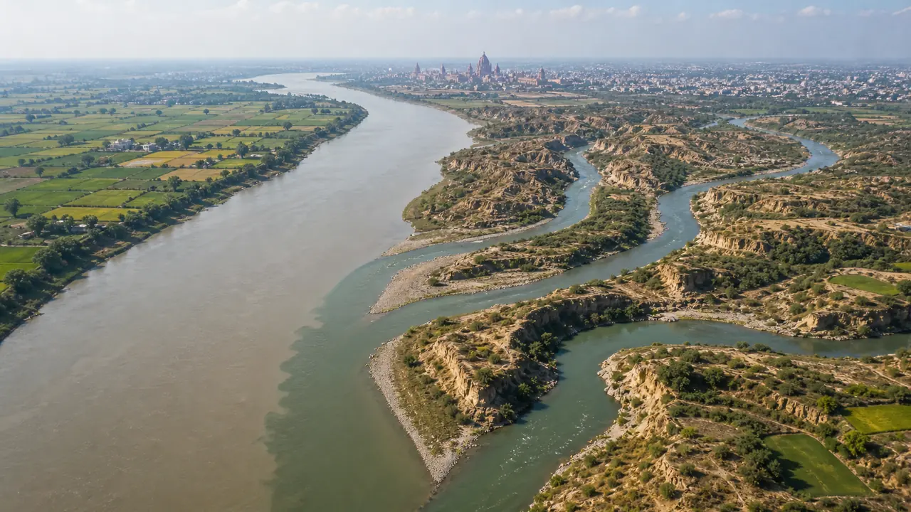
Yamuna's Course Through UP
The Yamuna flows through or along the border of western and southern UP, and its course connects very different regional landscapes: canal-fed plains, NCR urban belt, Braj, ravine country, Bundelkhand, and finally Prayagraj.
| Stretch | Districts | Key Features |
|---|---|---|
| Upper / northern reach | Saharanpur, Shamli, Baghpat side | Canal offtake zone; important for irrigation geography |
| NCR Region | Gautam Buddh Nagar (Noida) | Heavily polluted stretch, Hindon confluence |
| Braj Region | Mathura, Agra | Religious significance (Krishna Leela), Taj Mahal on banks |
| Etawah stretch | Etawah | Chambal confluence, ravine landscape |
| Bundelkhand | Jalaun, Hamirpur | Betwa and Ken confluences |
| Final stretch | Prayagraj | Meets Ganga at Sangam |
Major Tributaries of Yamuna in UP
| Tributary | Bank | Joins At | Key Detail |
|---|---|---|---|
| Hindon | Right | Near Noida | Most polluted tributary, flows through Ghaziabad |
| Chambal | Right | Near Etawah (UP-MP border) | Originates at Janapav Hills, MP; flows through Rajasthan |
| Betwa | Right | Near Hamirpur | Plateau river from MP; important for Bundelkhand geography |
| Ken | Right | Near Chilla (Banda) | From Vindhyas, flows through Panna (MP) |
| Sindh | Right | Near Etawah | From Vidisha (MP), passes through ravine country |
Note: A strong exam pattern is that many important Yamuna tributaries in the UP context join from the right bank. They mostly come from the southern plateau / ravine side, which is why Yamuna questions are often linked with Bundelkhand and Chambal badlands.
Hindon River — Western UP's Polluted Stream
| Parameter | Detail |
|---|---|
| Origin | Upper Shivalik Hills (Saharanpur) |
| Length | ~355 km |
| Flows through | Saharanpur, Muzaffarnagar, Shamli, Baghpat, Meerut, Ghaziabad, Noida |
| Joins | Yamuna near Noida |
| Pollution | Industrial effluents from NCR, sugar mills, paper mills |
| Status | Widely cited among the most polluted river stretches in the region |
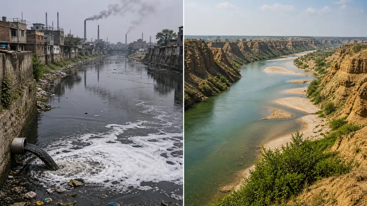
The Hindon matters because it shows the urban-industrial side of western UP river geography. In exams, it is often remembered as the polluted contrast to cleaner rivers such as parts of the Chambal system.
Chambal River
| Parameter | Detail |
|---|---|
| Origin | Janapav Hills near Mhow, MP |
| Total length | ~960 km |
| States | MP → Rajasthan → UP (border) |
| Joins Yamuna | Near Etawah/Auraiya border |
| Key feature | Chambal ravines (badlands) — severe soil erosion |
| Dams | Gandhi Sagar, Rana Pratap Sagar, Jawahar Sagar (all in Rajasthan) |
| Wildlife | National Chambal Sanctuary — gharial, river dolphins, mugger crocodiles |
The Chambal is often described as one of India's cleaner major rivers because much of its course runs through sparsely populated ravine terrain rather than dense industrial belts.
Western UP Drainage Pattern
Western UP has a distinct drainage character:
| Feature | Detail |
|---|---|
| Major rivers | Yamuna, Hindon, Kali (East & West), Krishni |
| Drainage direction | South to south-east |
| Soil | Alluvial (Khadar and Bhangar) |
| Terrain | Flat plains with ravines along Yamuna and Chambal |
| Agriculture | Sugarcane belt (Muzaffarnagar, Shamli, Baghpat) |
| Key concern | Groundwater depletion due to intensive farming and tube wells |
Kali River (East) — flows through Meerut, Bulandshahr; heavily polluted by industrial waste. Kali River (West) — flows through Muzaffarnagar; equally degraded.
This mixed drainage character is what makes western UP important: it combines fertile canal-irrigated plains with river pollution, groundwater stress, and ravine erosion along the Yamuna-Chambal side.
Yamuna Pollution Crisis
The Yamuna is among the most polluted major river stretches in India, and this pollution directly affects the UP stretch downstream of Delhi.
| Pollution Fact | Detail |
|---|---|
| Most polluted stretch | Delhi to Agra (~490 km) |
| Major pollutants | Domestic sewage, industrial effluents, agricultural runoff |
| Delhi's contribution | Delhi contributes a very large share of the pollution load entering the downstream Yamuna |
| Impact on UP | Water quality remains severely degraded in stretches from Noida toward Mathura and Agra |
| Cleanup efforts | Yamuna Action Plan I (1993), Phase II (2004), Phase III (ongoing) |
| Threat to Taj Mahal | Yamuna pollution and declining water levels affect Taj Mahal's wooden foundations |
Summary Cheat Sheet
| Fact | Answer |
|---|---|
| Yamuna reaches the UP side at | Saharanpur-Shamli side |
| Yamuna meets Ganga at | Prayagraj |
| Yamuna origin | Yamunotri glacier |
| Chambal joins Yamuna at | Near Etawah |
| Chambal origin | Janapav Hills, MP |
| Hindon flows through | Ghaziabad, Noida |
| Most polluted Yamuna stretch | Delhi to Agra |
| Betwa joins Yamuna at | Hamirpur |
| Chambal sanctuary wildlife | Gharial, dolphins |
| Western UP sugar belt | Muzaffarnagar, Shamli |
Lesson Doubts
Ask questions, get expert answers