🌍 Meteorology & Agro-Meteorology: Foundations for Agriculture
Understanding meteorology, atmospheric composition, weather vs climate, growing periods, seasons, climatic factors, scales of climate, and iso-lines — with agricultural applications and exam tips
Why Meteorology Matters to a Farmer
A wheat farmer in Punjab checks the forecast before sowing. A tea planter in Assam watches monsoon arrival dates. A millet grower in Rajasthan plans the entire season around a few weeks of rain. Every agricultural decision — from choosing a crop to scheduling irrigation — depends on understanding the atmosphere. That understanding begins with meteorology.
This lesson covers:
- Meteorology and Agro-meteorology — definitions and scope
- Atmospheric composition — gases by volume and weight
- Weather vs Climate — the critical distinction
- Sun and Earth — energy source, seasons, and heat flow
- Growing period — the water-availability window for dryland crops
- Seasons and climatic factors — what shapes India's agriculture
- Scales of climate and iso-lines — spatial tools for planning
- Meteorological instruments — what each device measures
All topics are high-yield for IBPS AFO, NABARD Grade A, and FCI exams.
What is Meteorology?
The word comes from two Greek roots:
- "Meteoro" = 'above the earth's surface' (atmosphere)
- "Logy" = 'indicating science'
Meteorology is the branch of science that studies the atmosphere — its composition, structure, and the processes that produce weather.
Agro-Meteorology
Agro-meteorology (short for agricultural meteorology) applies meteorological knowledge to agriculture. It deals with the measurement and analysis of the physical environment in agricultural systems.
Agricultural examples:
- Predicting frost dates to protect potato crops
- Using rainfall data to decide between sole cropping and intercropping
- Monitoring humidity to anticipate pest and disease outbreaks
Indian Meteorological Department (IMD)
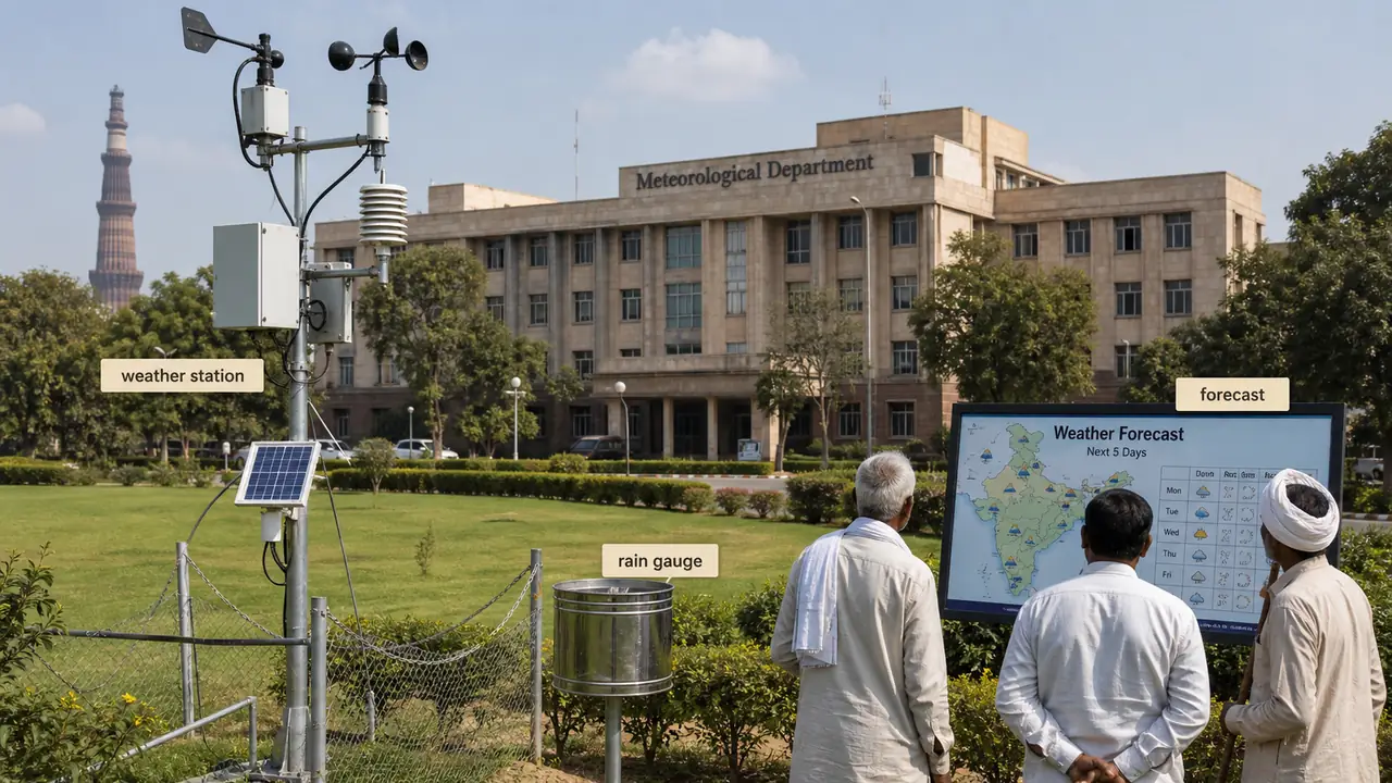
The Indian Meteorological Department (IMD) is the apex body for meteorological observations, weather forecasting, and seismology in India.
| Feature | Detail |
|---|---|
| Established | 1875 |
| Current HQ | New Delhi (Mausam Bhawan) |
| Ministry | Ministry of Earth Sciences |
HQ Shifts
| Year | Headquarters |
|---|---|
| 1875 | Calcutta |
| 1905 | Shimla |
| 1928 | Pune |
| 1944 | New Delhi (current) |
TIP
Exam Mnemonic for IMD HQ: "Calm Summer Pune Days" = Calcutta (1875) → Shimla (1905) → Pune (1928) → Delhi (1944).
Composition of the Atmosphere
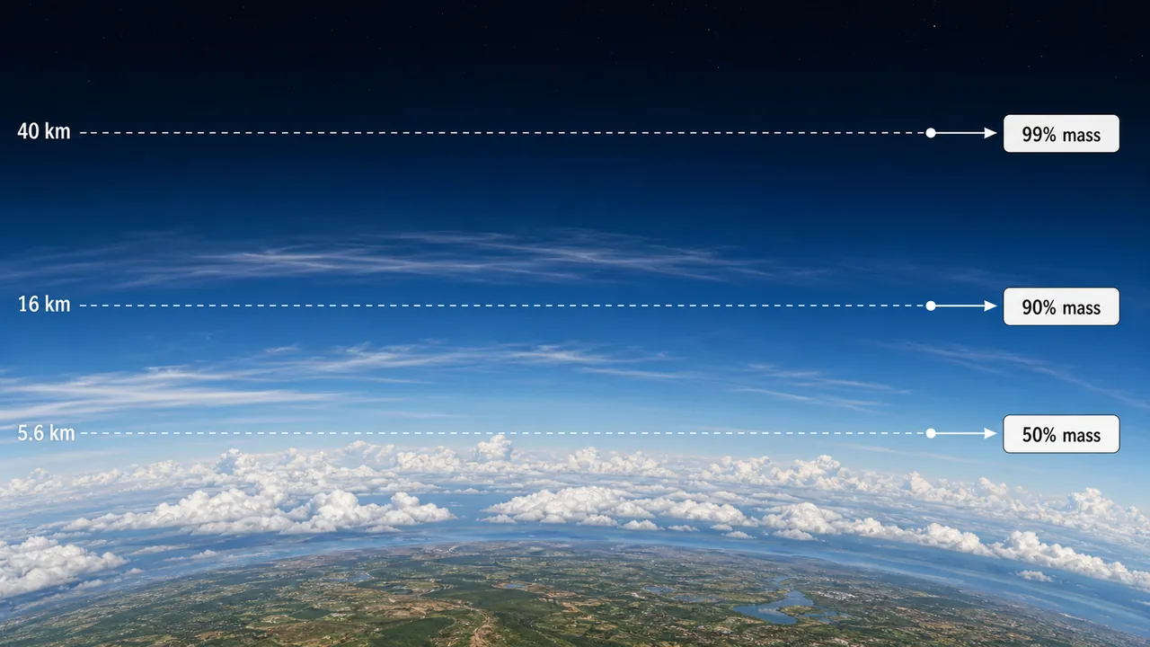
The atmosphere is a mixture of gases. Their proportions can be expressed by volume or by weight.
By Volume (%)
| Gas | Percentage by Volume |
|---|---|
| Nitrogen (N₂) | 78.08% |
| Oxygen (O₂) | 20.95% |
| Argon (Ar) | 0.93% |
| Carbon dioxide (CO₂) | 0.0412% |
| Neon (Ne) | 0.0018% |
By Weight (%)
| Gas | Percentage by Weight |
|---|---|
| Nitrogen (N₂) | 75.52% |
| Oxygen (O₂) | 23.14% |
| Argon (Ar) | 1.28% |
| Carbon dioxide (CO₂) | 0.045% |
Volume vs Weight — Quick Comparison
| Gas | By Volume | By Weight | Change |
|---|---|---|---|
| N₂ | 78.08% | 75.52% | Lower by weight (lighter molecule) |
| O₂ | 20.95% | 23.14% | Higher by weight (heavier molecule) |
TIP
Exam Mnemonic — "NOAC-Ne": The order by volume is N₂ > O₂ > Ar > CO₂ > Ne. Nitrogen dominates both by volume (78%) and weight (75%). Oxygen's share rises when measured by weight because O₂ is heavier than N₂.
Agricultural relevance: Nitrogen is the most abundant atmospheric gas and is fixed by legumes (Rhizobium bacteria) for crop nutrition. CO₂, though only 0.04%, drives photosynthesis — the foundation of all crop production.
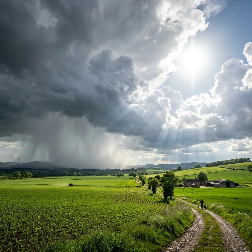
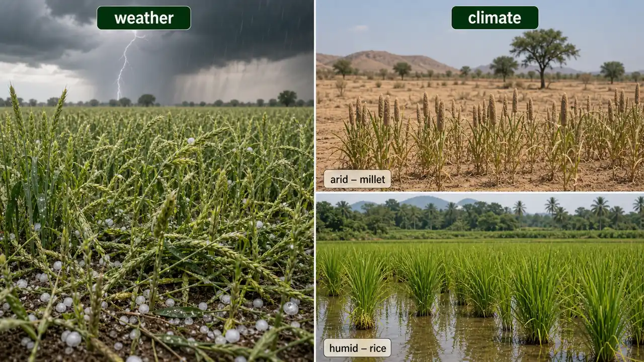
Weather vs Climate
These two terms are frequently confused. Understanding the distinction is critical for both farming and exams.
Weather
- The state or condition of the atmosphere at a given place and at a given instant of time.
- Covers small areas and short durations (hours to days).
- Weather elements include solar radiation, temperature, pressure, wind, humidity, rainfall, and evaporation.
- It changes constantly — sometimes from hour to hour.
Farm example: A sudden hailstorm during the rabi season can destroy a standing wheat crop in one afternoon — that is a weather event.
Climate
- The generalized weather or summation of weather conditions over a region during a longer period.
- Covers larger areas (a zone, state, or country) and is described by statistical normals.
- Climatic normals are generally worked out for a period of 30 years.
Farm example: Rajasthan's arid climate (low annual rainfall, high temperatures) makes it suitable for bajra and guar, not rice — that is a climate-based decision.
Micro-climatology
Micro-climatology is the study of the zone between the highest plant level and the lowest depth to which air penetrates soil. This is the immediate environment that crops actually experience — and it can differ significantly from the broader regional climate. Understanding micro-climatology helps farmers manage mulching, canopy structure, and soil aeration.
Differences Between Weather and Climate
| Feature | Weather | Climate |
|---|---|---|
| Definition | Physical condition of atmosphere at a point in time | Generalized atmospheric conditions over a long period |
| Area covered | Small locality | Large regions (state, country, zone) |
| Time scale | Changes every moment | Requires years to change |
| Agricultural use | Crop growth, development, and yield in a given season | Selection of crops suitable for a region |
| Planning type | Short-term contingent planning | Long-term agricultural planning |
| Variation factor | More than 50% of crop yield variation is due to weather/climate | Climate is the most important dominating factor for crop suitability |
IMPORTANT
Exam tip: Weather decides yield in a season. Climate decides crop choice for a region. Climate normals use 30 years of data.
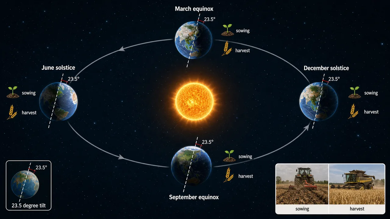
Sun and Earth
The Sun is the primary energy source for all weather, climate, and agricultural production on Earth. Understanding the Sun-Earth relationship explains why seasons change and how light drives crop growth.
| Fact | Value | Agricultural Significance |
|---|---|---|
| Distance: Earth to Sun | 1.5 x 10⁸ km | Determines total solar energy received on Earth |
| Earth's axial tilt | 23.5 degrees | Causes changing seasons — the single biggest driver of crop calendars |
| Equinoxes (equal day & night) | March 21 & September 23 | Mark seasonal transitions; day length = night length |
| Summer solstice (longest day, N. Hemisphere) | June 21 | Maximum day length — peak photosynthetic potential for kharif crops |
| Winter solstice (shortest day, N. Hemisphere) | December 21 | Minimum day length — critical for photoperiod-sensitive rabi crops |
| Blue sky / red sunset | Due to light dispersion (scattering) | Short wavelengths (blue) scatter more; long wavelengths (red) pass through at sunset |
| Albedo (reflected radiation) | Varies by surface | White colour reflects; black absorbs more radiation. Dark soils warm faster in spring |
| Visible radiation range | 0.39–0.76 micron | The portion of the electromagnetic spectrum our eyes detect |
| Most favourable light for plants | Red light | Efficiently absorbed by chlorophyll for photosynthesis |
| PAR measurement unit | Einstein units (EU) | PAR = 400–700 nm (photosynthetically active radiation) |
Heat Flow Mechanisms
Heat energy moves through the environment by three mechanisms — an important concept for understanding soil warming, frost formation, and greenhouse effects.
| Mechanism | Medium Required? | How It Works | Agricultural Example |
|---|---|---|---|
| Conduction | Yes (solid contact) | Heat passes molecule-to-molecule through a material | Heat transfer through soil layers; metal tools feel hot in sun |
| Convection | Yes (fluid movement) | Warm fluid rises, cool fluid sinks — creating circulation | Warm air rising from a heated field surface; sea breeze near coasts |
| Radiation | No (travels through vacuum) | Energy travels as electromagnetic waves | Solar energy reaching Earth from the Sun across space |
TIP
Exam facts: Earth's axial tilt of 23.5° causes seasons. Equinoxes = March 21 & September 23. Summer solstice = June 21, Winter solstice = December 21. Visible light = 0.39–0.76 micron. PAR is measured in Einstein units. Red light is most favourable for plants. Of the three heat flow mechanisms, only radiation needs no medium.
Growing Period
The length of growing period (LGP) is the period during which available soil moisture is enough to meet the evapotranspiration requirement of dryland crops, assuring dryland productivity.
| Length of Growing Period | Crop Possibility | Agricultural Example |
|---|---|---|
| < 5 weeks | Crop failures will occur | Western Rajasthan desert areas |
| Minimum 14 weeks (98 days) | Dryland crop attains potential productivity | Short-duration millets like bajra |
| 14 weeks | A single dryland crop | Sole sorghum or sole groundnut |
| 14 to 20 weeks | Intercropping system possible | Sorghum + pigeonpea intercrop |
| > 20 weeks | Long-duration crop or double cropping | Rice followed by wheat (Indo-Gangetic plains) |
IMPORTANT
Key number for exams: A minimum of 14 weeks (98 days) growing period is required for a dryland crop to attain its potential productivity.
Influence of Climate on Crops

- Climate is the most important dominating factor influencing crop suitability for a region.
- More than 50 per cent of crop yield variation is determined by climate.
- The three most important climatic factors: solar radiation, temperature, and rainfall.
Agricultural examples:
- Solar radiation — Sugarcane needs high light intensity; betel vine prefers shade.
- Temperature — Wheat needs cool winters (rabi); rice needs warm summers (kharif).
- Rainfall — Rice needs >1000 mm; bajra thrives in 300-500 mm.
Seasons
India experiences four broad seasons, each with distinct agricultural activities:
| Season | Months | Agricultural Significance |
|---|---|---|
| Spring | January to March | Fresh leaves form; mustard harvested; spring planting of vegetables |
| Summer | April to June | Flowering and fruiting; mango season; land preparation for kharif |
| Autumn | July to September | Peak kharif season; SW monsoon rains; rice transplanting |
| Winter | October to December | Rabi sowing; wheat, gram, mustard planted; frost risk in north India |
TIP
Mnemonic — "SS AW": Spring (Jan-Mar) → Summer (Apr-Jun) → Autumn (Jul-Sep) → Winter (Oct-Dec). Each season spans exactly 3 months.
Factors Affecting Climate
Climate is not uniform — it varies from place to place based on geography, topography, and proximity to water. Six major factors determine the climate of a region:
| Factor | How It Affects Climate | Agricultural Impact |
|---|---|---|
| Latitude | Distance from equator creates temperature zones (Tropical → Sub-tropical → Temperate → Polar) | Tropical crops (rice, sugarcane) near equator; temperate crops (apple, wheat) at higher latitudes |
| Precipitation | Quantity and distribution decides vegetation type | Arid: millets; Humid: rice, jute |
| Soil type | White colour reflects; black absorbs more radiation. Black soil areas are hotter. | Black soils (Deccan) suit cotton; red soils (Chotanagpur) suit millets |
| Nearness to water bodies | Moderates temperature extremes | Coastal Kerala has uniform temperatures year-round |
| Topography | Elevation and slope affect temperature, rainfall | Hill stations grow tea, coffee; plains grow cereals |
| Vegetation | Forests moderate local climate through transpiration | Deforestation increases temperature extremes |
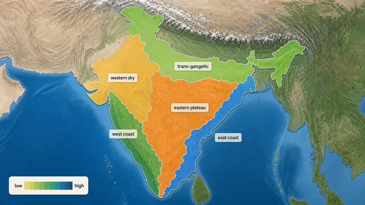
Rainfall-Based Climatic Regions
| Rainfall (mm) | Climatic Region | Typical Crops |
|---|---|---|
| Less than 500 | Arid | Bajra, guar, moth bean |
| 500–750 | Semi-arid | Sorghum, groundnut, cotton |
| 750–1000 | Sub-humid | Wheat, maize, sugarcane |
| Above 1000 | Humid | Rice, jute, tea |
Troll's Modified Classification (Used by ICRISAT)
| Climate | Humid Months | % of India's Geographical Area |
|---|---|---|
| Arid | < 2.0 | 17% |
| Semi-arid dry | 2.0–4.5 | 57.17% |
| Semi-arid wet | 4.5–7.0 | 12.31% |
| Humid | > 7.0 | 1.10% |
TIP
Exam fact: Semi-arid dry covers the largest area of India (57.17%). This explains why dryland agriculture is so important in the Indian context.
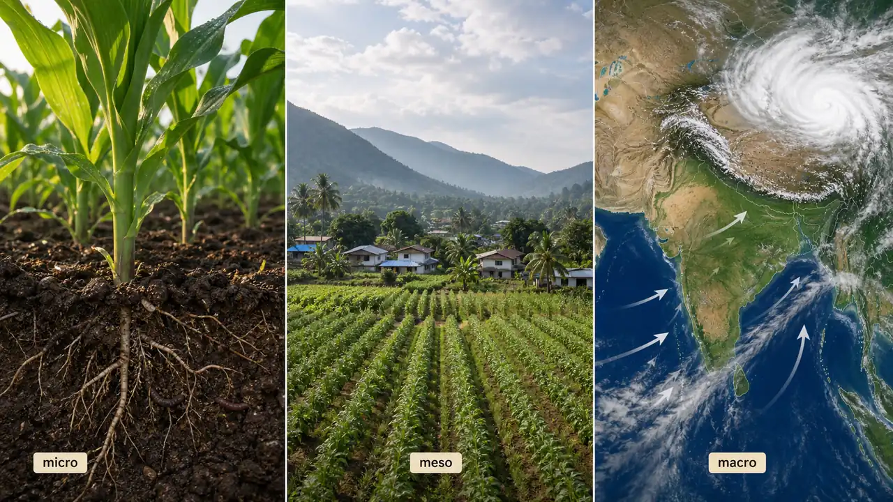
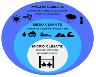
Scales of Climate
Climate can be studied at three spatial scales, each relevant to different agricultural decisions:
| Scale | Coverage | Agricultural Application |
|---|---|---|
| Microclimate | Very small areas; air layer near the ground | Crop canopy temperature, mulching effects, greenhouse conditions |
| Mesoclimate | Between micro and macro; 10–100 km across | Valley-level planning, orchard site selection, watershed management |
| Macroclimate | Large areas of the earth; large-scale atmospheric motions | National crop zoning, agro-climatic region planning |
Farm example: A farmer uses microclimate knowledge when applying mulch to keep soil cool. The Planning Commission uses macroclimate data to define India's 15 agro-climatic zones.
Iso-lines (Lines of Equal Value)
Iso-lines are lines drawn on maps connecting points with equal values of a particular parameter. They are essential tools in meteorology, geography, and agricultural planning.
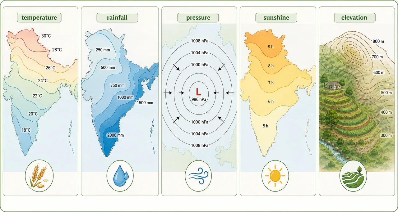
| Iso-line | Connects Points of Equal | Agricultural Relevance |
|---|---|---|
| Isotherm | Temperature | Crop thermal zone mapping |
| Isohyet | Rainfall | Rainfall zone delineation for cropping patterns |
| Isobar | Atmospheric pressure | Wind and storm prediction |
| Isohel | Sunshine duration | Photoperiod-sensitive crop planning |
| Isotach | Wind speed | Windbreak and shelter belt planning |
| Isophene | Phenological events (flowering, harvest) | Crop calendar synchronization |
| Contour (Isohypse) | Elevation / Height above sea level | Contour farming, terrace planning |
| Isobath | Depth (below water surface) | Fishery and irrigation reservoir planning |
| Isopleth | Any quantitative variable (general term) | General spatial analysis |
| Isopluvial | Equal rainfall intensity for a given duration | Drainage and flood management |
| Isohaline | Salinity (of ocean/water) | Coastal agriculture, aquaculture |
| Isodemic | Population density | Market and labour availability |
| Isoneph | Cloudiness / Cloud cover | Light availability for crops |
| Isostere | Specific volume (of a gas) | Atmospheric research |
| Isocline | Magnetic inclination (dip) | Navigation, surveying |
| Isogon | Magnetic declination | Navigation, surveying |
TIP
Most asked in exams: Use the mnemonic "IT-IR-IP" — Isobar = Pressure, Isotherm = Temperature, Isohyet = Rainfall. Also remember: Isohel = Sunshine, Isotach = Wind speed, Isophene = Phenological events, Contour = Elevation.
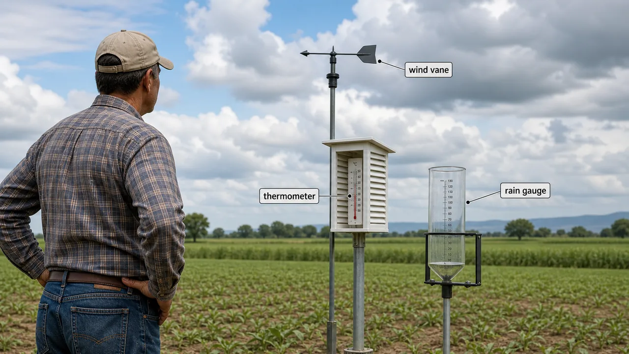
Meteorological Instruments
Accurate measurement of weather elements is the foundation of agricultural meteorology. Each instrument below measures a specific atmospheric parameter — and knowing which instrument measures what is regularly asked in exams, IBPS-SO, and exams.
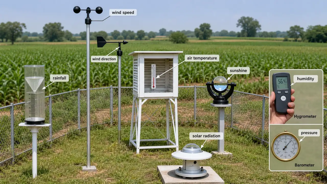
Weather Instruments
| Measures | Instrument |
|---|---|
| Rainfall | Rain gauge |
| Wind velocity | Anemometer |
| Wind direction | Wind vane |
| Wind force/speed scale | Beaufort Scale |
| Atmospheric pressure | Barometer |
| Relative humidity (indirect) | Psychrometer / Hygrometer |
| Continuous relative humidity | Hygrograph |
| RH in crop canopy | Asmann Psychrometer |
| Continuous air temperature | Thermograph |
| Duration of bright sunshine (India) | Campbell-Stokes Sunshine Recorder |
| Duration of sunshine hours | Heliograph |
Radiation Instruments
| Measures | Instrument |
|---|---|
| Total incoming solar radiation | Pyranometer |
| Direct solar radiation | Pyrheliometer |
| Solar radiation (long wave) | Pyrgeometer |
| Radiation reflectivity (albedo) | Albedometer |
| Wavelength of light | Spectrophotometer |
TIP
Most asked in exams: Campbell-Stokes = sunshine hours in India. Pyranometer = total solar radiation. Anemometer = wind speed. Psychrometer = RH measurement. Beaufort Scale = wind force.
Summary Table
| Topic | Key Fact | Exam Value |
|---|---|---|
| Meteorology | Greek "Meteoro" = above earth's surface | Definition question |
| Agro-meteorology | Application of meteorology to agriculture | Definition question |
| Atmosphere — N₂ | 78.08% by volume, 75.52% by weight | Frequently asked |
| Atmosphere — O₂ | 20.95% by volume, 23.14% by weight | Frequently asked |
| Weather | Condition at a given place and time; changes constantly | Comparison question |
| Climate | Generalized weather over 30 years | Comparison question |
| Micro-climatology | Zone from highest plant level to lowest soil air depth | Definition question |
| Earth-Sun distance | 1.5 x 10⁸ km | Numerical question |
| Earth's axial tilt | 23.5° — causes seasons | Frequently asked |
| Equinoxes | March 21 & September 23 | Date question |
| Summer solstice | June 21 (longest day, N. Hemisphere) | Date question |
| Winter solstice | December 21 (shortest day, N. Hemisphere) | Date question |
| Visible radiation | 0.39–0.76 micron | Range question |
| Best light for plants | Red light | Frequently asked |
| PAR unit | Einstein units (EU) | Unit question |
| Heat flow — no medium | Radiation | Mechanism question |
| Growing period (minimum) | 14 weeks (98 days) for dryland crop productivity | Numerical question |
| Growing period > 20 weeks | Double cropping possible | Cropping system question |
| Climate influence on crops | > 50% yield variation due to climate | Percentage question |
| Key climatic factors | Solar radiation, temperature, rainfall | Listing question |
| Seasons | Spring (Jan-Mar), Summer (Apr-Jun), Autumn (Jul-Sep), Winter (Oct-Dec) | Matching question |
| Rainfall < 500 mm | Arid region | Classification question |
| Troll's — Semi-arid dry | 57.17% of India's area | Area percentage |
| Mesoclimate | 10–100 km across | Scale question |
| Isotherm | Lines of equal temperature | Definition question |
| Isohyet | Lines of equal rainfall | Definition question |
| Isobar | Lines of equal pressure | Definition question |
Summary Cheat Sheet
| Concept / Topic | Key Details |
|---|---|
| Meteorology | Greek "Meteoro" = above earth's surface |
| Agro-meteorology | Application of meteorology to agriculture |
| Atmosphere N₂ | 78.08% by volume, 75.52% by weight |
| Atmosphere O₂ | 20.95% by volume, 23.14% by weight |
| Weather vs Climate | Weather = given place/time; Climate = generalized over 30 years |
| Micro-climatology | Zone from highest plant level to lowest depth air penetrates soil |
| Earth-Sun distance | 1.5 x 10⁸ km |
| Earth's axial tilt | 23.5° — causes seasons |
| Equinoxes | March 21 & September 23 |
| Summer solstice | June 21 (longest day, N. Hemisphere) |
| Winter solstice | December 21 (shortest day, N. Hemisphere) |
| Visible radiation | 0.39–0.76 micron |
| Best light for plants | Red light (absorbed by chlorophyll) |
| PAR unit | Einstein units (EU); PAR = 400–700 nm |
| Heat transfer without medium | Radiation |
| Minimum growing period | 14 weeks (98 days) for dryland crop productivity |
| Growing period > 20 weeks | Double cropping possible |
| Climate influence on yield | > 50% yield variation due to climate |
| Seasons | Spring (Jan-Mar), Summer (Apr-Jun), Autumn (Jul-Sep), Winter (Oct-Dec) |
| Rainfall < 500 mm | Arid region |
| Troll's Semi-arid dry | 57.17% of India's area |
| Mesoclimate | 10-100 km across |
| Isotherm | Lines of equal temperature |
| Isohyet | Lines of equal rainfall |
| Isobar | Lines of equal pressure |
| Isohel | Lines of equal sunshine duration |
| Isotach | Lines of equal wind speed |
| Isophene | Lines of equal phenological events |
| Contour (Isohypse) | Lines of equal elevation |
| Mnemonic | IT-IR-IP — Isobar=Pressure, Isotherm=Temperature, Isohyet=Rainfall |
TIP
Next: Lesson 02 explores the vertical structure of the atmosphere — the five atmospheric layers, lapse rates, and the ozone shield that protects crops from UV damage.
Lesson Doubts
Ask questions, get expert answers