💦 Water Distribution on Earth: The Hydrologic Cycle and India's Water Budget
How water is distributed across Earth, the hydrologic cycle and its four components, surface and groundwater resources, aquifer types, and India's water budget -- essential concepts for agricultural water management and competitive exams.
A Borewell That Ran Dry
A farmer in semi-arid Rajasthan drills a borewell hoping to irrigate his mustard crop. The first year, water flows freely. By the third year, the yield drops to a trickle. Why? The aquifer beneath his land recharges slowly from distant rainfall, and years of over-extraction have lowered the water table beyond reach. Whether a well yields water -- and for how long -- depends on rainfall patterns, aquifer type, and groundwater recharge. All of these are governed by how water is distributed on Earth. Understanding the hydrologic cycle and water resources is the foundation for every irrigation and water management decision in agriculture.
This lesson covers:
- Distribution of water resources on Earth and the conservation principle
- The hydrologic cycle -- precipitation, runoff, storage, and evapotranspiration
- Classification of water resources -- surface water, groundwater, and aquifer types
- India's water budget -- rainfall, availability, and the numbers that appear in exams
All sections are high-yield for exams, NABARD, and state agriculture officer exams.
Pro Content Locked
Upgrade to Pro to access this lesson and all other premium content.
Charged once for one year · ₹1188 total
Save ₹100/month vs ₹2388/year launch price
- All Agriculture & Banking Courses
- AI Lesson Questions (100/day)
- AI Doubt Solver (50/day)
- Glows & Grows Feedback (30/day)
- AI Section Quiz (20/day)
- 22-Language Translation (100/day)
- Recall Questions (20/day)
- AI Quiz (15/day)
- AI Quiz Paper Analysis (100/day)
- AI Step-by-Step Explanations (100/day)
- Spaced Repetition Recall (FSRS)
- AI Tutor
- Immersive Text Questions
- Audio Lessons — Hindi & English
- Mock Tests & Previous Year Papers
- Summary & Mind Maps
- XP, Levels, Leaderboard & Badges
- Generate New Classrooms
- Voice AI Teacher (AgriDots Live)
- AI Revision Assistant
- Knowledge Gap Analysis
- Interactive Revision (LangGraph)
🔒 Secure one-time yearly payment via Razorpay · No hidden fees
A Borewell That Ran Dry
A farmer in semi-arid Rajasthan drills a borewell hoping to irrigate his mustard crop. The first year, water flows freely. By the third year, the yield drops to a trickle. Why? The aquifer beneath his land recharges slowly from distant rainfall, and years of over-extraction have lowered the water table beyond reach. Whether a well yields water -- and for how long -- depends on rainfall patterns, aquifer type, and groundwater recharge. All of these are governed by how water is distributed on Earth. Understanding the hydrologic cycle and water resources is the foundation for every irrigation and water management decision in agriculture.
This lesson covers:
- Distribution of water resources on Earth and the conservation principle
- The hydrologic cycle -- precipitation, runoff, storage, and evapotranspiration
- Classification of water resources -- surface water, groundwater, and aquifer types
- India's water budget -- rainfall, availability, and the numbers that appear in exams
All sections are high-yield for exams, NABARD, and state agriculture officer exams.
Distribution of Water Resources on Earth

Water exists in the atmosphere, oceans, on land, and within soil and rock. Water molecules move from one location to another driven by solar energy. Moisture circulates from the earth into the atmosphere through evaporation and returns as precipitation.
This continuous process is the Hydrologic Cycle -- water is conserved, meaning it is neither created nor destroyed. The total amount of water on Earth remains essentially constant, but it continuously moves between reservoirs (oceans, atmosphere, land surface, and underground).
IMPORTANT
Water is neither created nor destroyed -- it only changes form and location. This principle of conservation of water is the foundation of all water budget calculations.
Agricultural relevance: Of all the water on Earth, less than 1% is available as freshwater for agriculture. This scarcity makes efficient water management critical for food production.
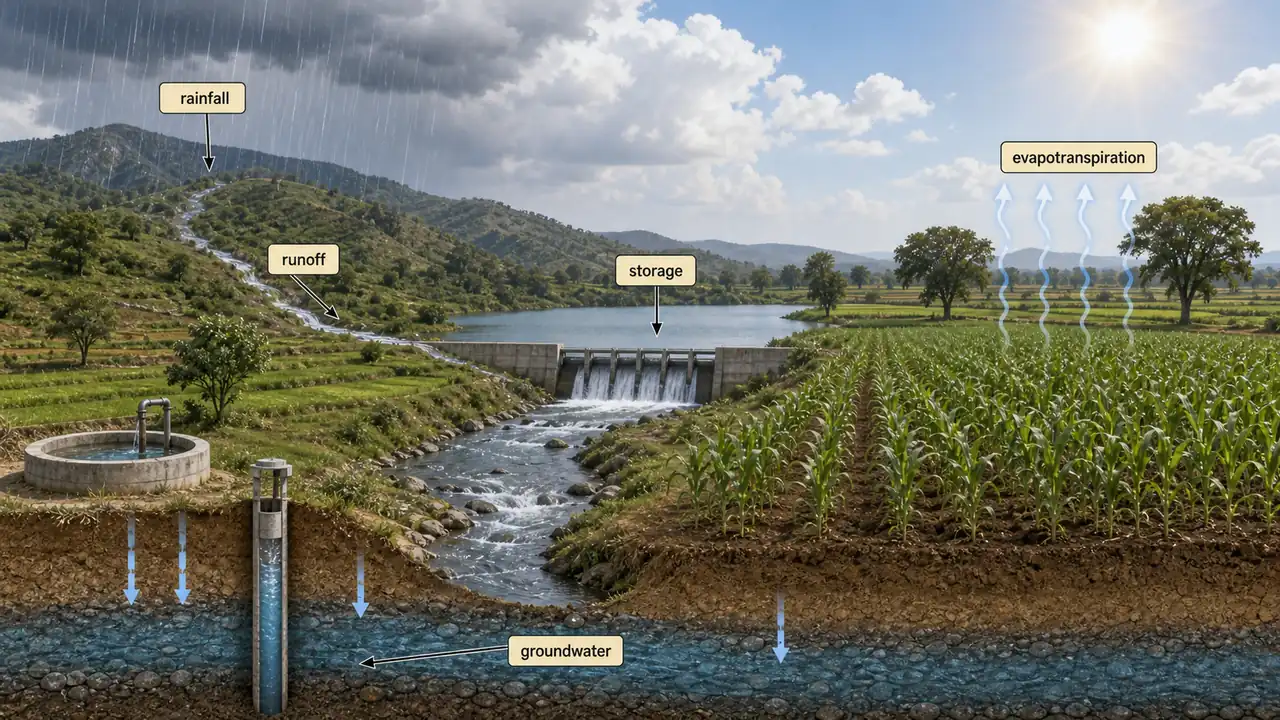
The Hydrologic Cycle
The hydrologic cycle (also called the water cycle) describes the continuous movement of water on, above, and below the surface of the Earth. Think of it as nature's irrigation system -- it moves water from oceans to clouds to fields and back again.
It consists of 4 key components:
| Component | What Happens | Agricultural Relevance |
|---|---|---|
| Precipitation | Water falls as rain, snow, hail, frost, dew | Primary water source for rainfed crops |
| Runoff | Excess water flows across land surface | Causes soil erosion; harvested in farm ponds |
| Storage | Water stored in lakes, reservoirs, and as groundwater | Provides irrigation water during dry spells |
| Evapotranspiration | Water returns to the atmosphere from soil and plants | Determines how much water crops actually need |

TIP
Exam mnemonic -- "PRSE": The four components of the hydrologic cycle in order: Precipitation, Runoff, Storage, Evapotranspiration. Water falls (P), flows (R), is stored (S), and returns to the atmosphere (E).
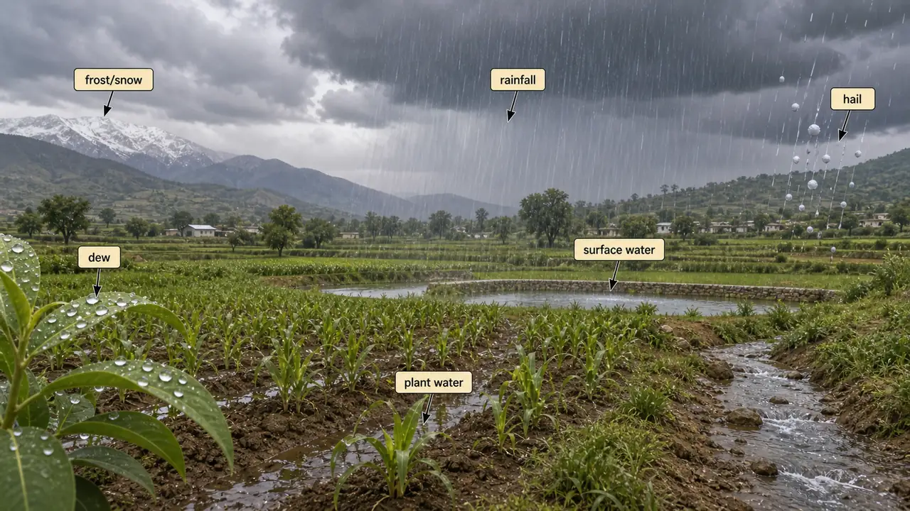
Precipitation
- Occurs when atmospheric moisture becomes too heavy to remain suspended in clouds.
- Includes all forms: rainfall, snowfall, hail, frost, and dew.
- Once it reaches the earth's surface, precipitation becomes surface runoff, storage, plant water, groundwater, or evaporates back.
- Ocean evaporation is the greatest source (about 90%) of precipitation.
- Rainfall is the predominant form and its distribution varies significantly, directly impacting agricultural planning.
Agricultural example: In India's monsoon regions, nearly 80% of annual rainfall occurs in just 4 months (June--September). This concentrated rainfall pattern is why water storage and irrigation are essential for year-round cropping. A rice farmer in West Bengal depends on monsoon rains for kharif paddy, but needs stored water or irrigation for boro (winter) rice.
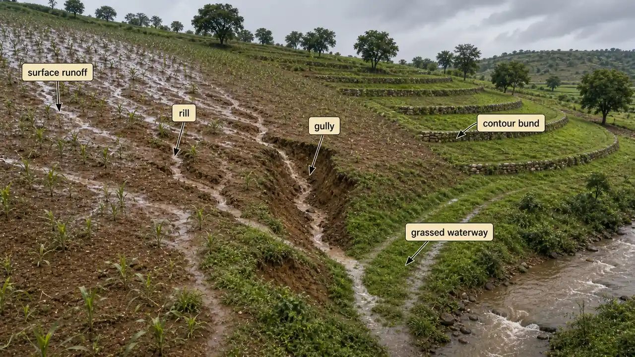
Runoff
- Water that flows across the land surface after a storm event -- the portion not absorbed by soil or evaporated.
- As flow intensifies, it carves rills and gullies which combine into channels, streams, and rivers.
- The geographical area contributing to a river's flow is called a river basin or watershed.
Agricultural example: On sloping farmland in the Western Ghats, uncontrolled runoff can wash away 20--40 tonnes of topsoil per hectare per year. Farmers use contour bunding and grassed waterways to slow runoff, reduce erosion, and improve water infiltration into the root zone.
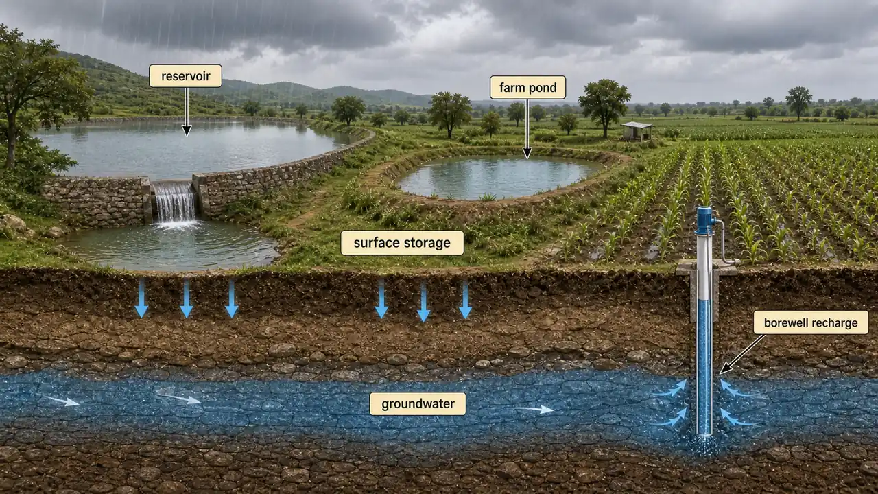
Storage
- Precipitation that does not flow as runoff gets stored as surface water (lakes, reservoirs, wetlands) or groundwater.
- Groundwater storage is much greater than surface storage, but not all of it can be extracted practically.
- Groundwater moves from regions of higher potential to lower, but very slowly compared to surface water -- making it a stable but slowly rechargeable source.
Agricultural example: Farm ponds in Maharashtra's dryland regions store monsoon runoff, providing protective irrigation during critical dry spells in the post-monsoon rabi season. A single 10 m x 10 m x 3 m farm pond can store enough water for one supplemental irrigation of approximately 0.5 hectare.
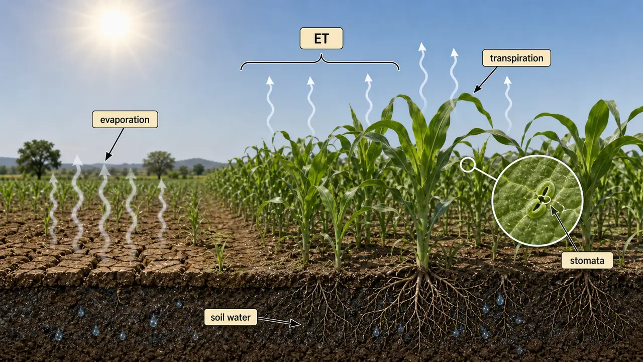
Evapotranspiration
- Combination of evaporation (liquid to vapour from soil and water surfaces) and transpiration (water loss from plant leaves through stomata).
- Together, evapotranspiration determines crop water requirement.
TIP
Exam mnemonic: ET = E + T (Evapotranspiration = Evaporation + Transpiration). This combined term is used throughout irrigation science because both processes together determine how much water a field loses to the atmosphere.
Agricultural example: In a sugarcane field in Maharashtra, ET can reach 8--10 mm per day during the grand growth phase. If the farmer does not irrigate to replace this water loss, the crop suffers severe moisture stress and cane yield drops sharply.
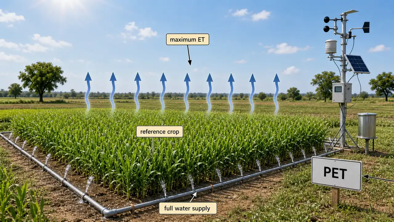
Potential Evapotranspiration (PET)
- Amount of water evaporated per unit time from a short, uniform green crop that is actively growing, fully covering the surface, and never short of water.
- Represents the maximum possible evapotranspiration under ideal moisture conditions.
- Penman prefers the term potential transpiration.
- PET is widely used in irrigation scheduling and water budget calculations.
Agricultural example: If PET in a region is 5 mm/day and a wheat crop has been growing for 100 days, the maximum ET demand is roughly 500 mm -- this helps estimate the total irrigation water needed for the season.
Classification of Water Resources
Water resources are broadly classified into surface water (visible -- rivers, lakes, reservoirs) and sub-surface water (hidden -- aquifers and springs). Surface sources are easier to access but seasonal and vulnerable to pollution, while groundwater is more reliable but recharges slowly. For agriculture, both sources matter -- canals draw from surface water, borewells tap groundwater.
| Category | Examples | Key Features |
|---|---|---|
| Surface Water | Rivers, lakes, streams, reservoirs, wetlands, oceans | Easier to access; susceptible to contamination and seasonal variation |
| Sub-Surface Water (Groundwater) | Aquifers, springs, underground streams | Larger volume; slower to recharge; more reliable year-round |
Main uses of surface water: drinking, irrigation, and thermoelectric power cooling.
Surface Water vs Groundwater -- Comparison
| Feature | Surface Water | Groundwater |
|---|---|---|
| Availability | Seasonal, depends on rainfall | Year-round, more stable |
| Volume | Smaller (visible) | Much larger (hidden) |
| Recharge speed | Quick (direct rainfall) | Slow (infiltration through soil) |
| Quality | Vulnerable to pollution | Naturally filtered, better quality |
| Access | Easy (canals, pumps) | Requires borewells, tube-wells |
| Agricultural use | Canal irrigation | Tube-well and well irrigation |
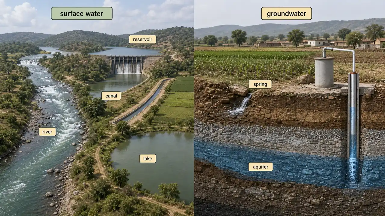
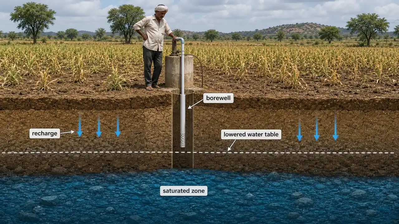
Groundwater
- Comes from rain and snowmelt that seeps into the ground.
- Gravity pulls water down through soil spaces and rock cracks.
- When all openings in soil or rock are filled with water, this is the saturated zone.
- The top of the saturated zone is the water table, which rises and falls with seasons and rainfall.
- Bedrock below the saturated zone prevents deeper penetration.

Agricultural example: In Punjab, intensive tube-well irrigation for rice-wheat rotation has caused the water table to drop by 0.5--1 m per year, requiring ever-deeper borewells -- a direct consequence of extracting groundwater faster than it recharges. This is why Punjab now promotes direct-seeded rice (DSR) to reduce water consumption.
Movement of Water Through Soil and Rock
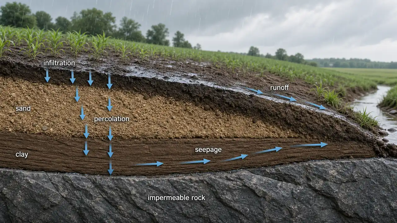
| Material | Pore Size | Water Movement | Agricultural Implication |
|---|---|---|---|
| Gravel | Very large | Very fast | Poor water retention; needs frequent irrigation |
| Sand | Large | Fast | Light irrigation at short intervals |
| Clay | Very small | Almost none | Retains water well but prone to waterlogging |
| Solid rock | No pores | Impermeable | Acts as barrier; water pools above it |
The difference in water movement rates is called hydraulic conductivity. An impermeable layer is rock so solid that it blocks water entirely. Crumbly rock with connected cracks allows water to pass through.
Aquifers

A saturated soil or rock layer that allows water to move through it is an aquifer. The pores act as a natural filtration system, removing even viruses and bacteria. Aquifers are the underground reservoirs that supply water to tube-wells and borewells used across Indian agriculture.
Unconfined vs Confined Aquifers
| Feature | Unconfined Aquifer | Confined Aquifer |
|---|---|---|
| Upper boundary | Water table (open to atmosphere) | Impermeable rock/clay layer |
| Depth | Shallower | Deeper |
| Recharge | Direct from rain/streams | Indirect, from distant recharge zones |
| Pressure | Atmospheric | Under artesian pressure (water rises in borehole) |
| Response to rainfall | Quick | Slow (water can be thousands of years old) |
| Vulnerability to pollution | Higher | Lower |
| Examples | Coastal sands, alluvial deposits | Deep sandstone layers |
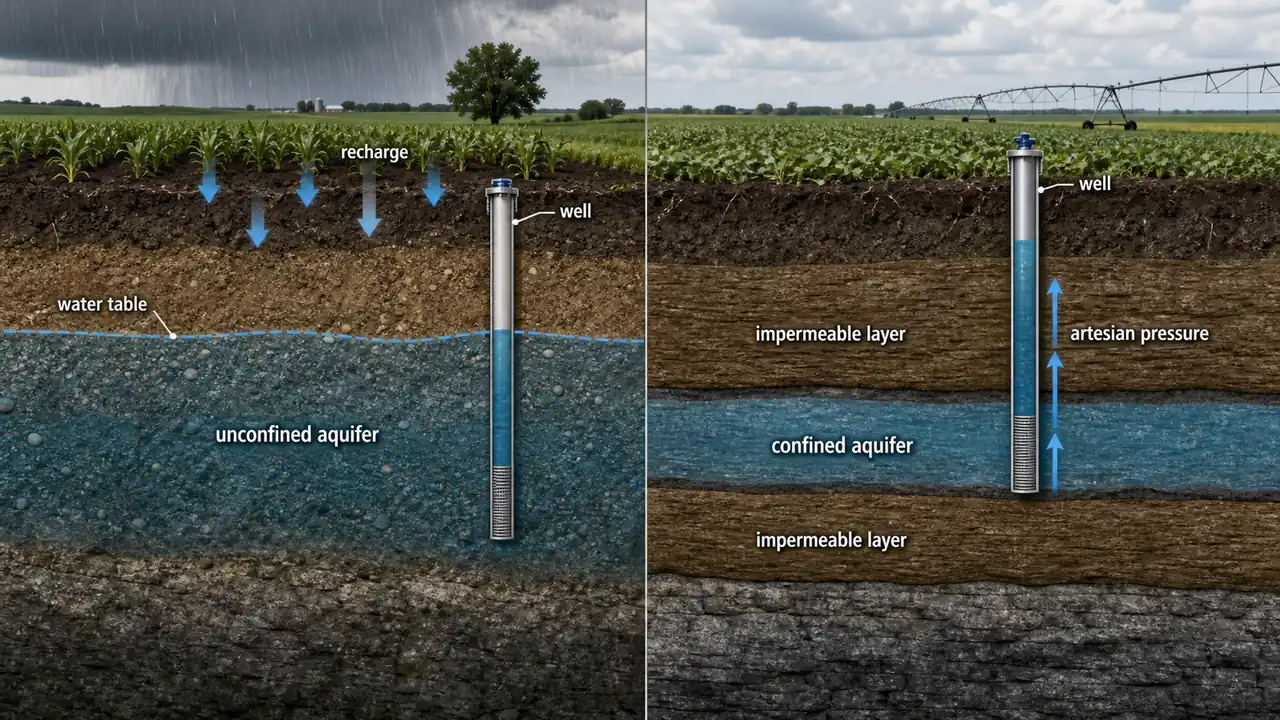
NOTE
Unconfined aquifers have the water table as their upper boundary and are recharged directly by surface water. Confined aquifers are sandwiched between impermeable layers and hold water under artesian pressure. Both types are critical sources of irrigation water.
Agricultural example: In parts of Gujarat, farmers tap confined aquifers through deep borewells. When the artesian pressure is sufficient, water flows to the surface without pumping -- an artesian well -- reducing energy costs for irrigation.
TIP
Exam tip: Remember "U for Up and Unconfined" -- unconfined aquifers are closer to the surface (up) and open to atmospheric pressure. Confined aquifers are deeper and under pressure.
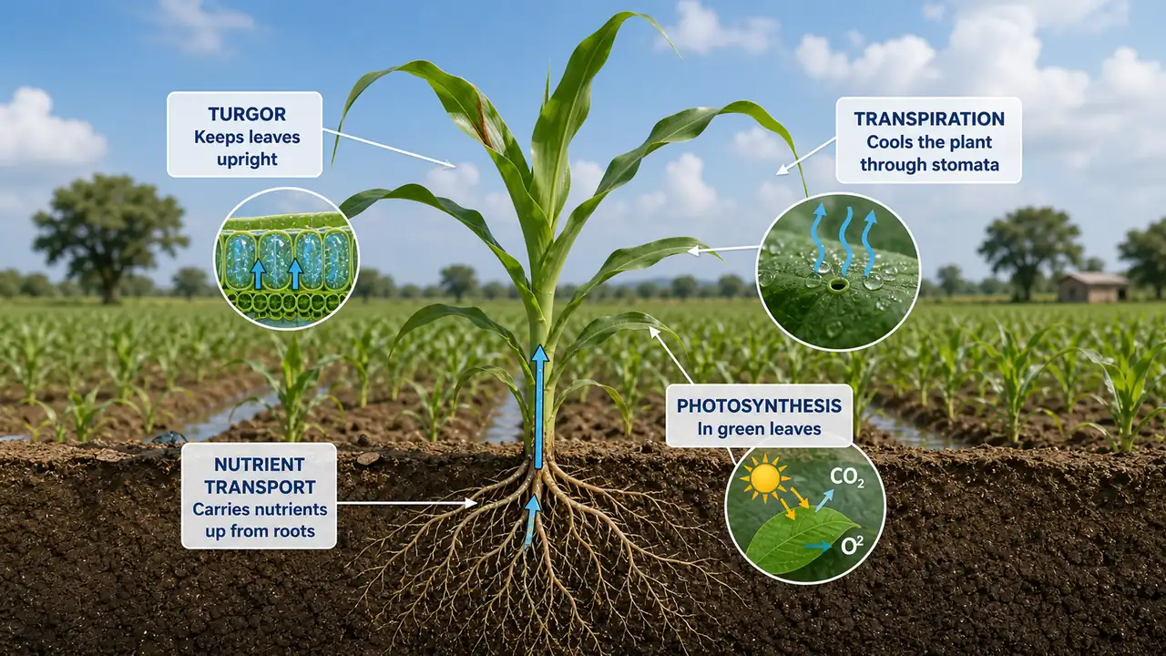
Functions of Water in Plants
Water serves as a solvent for nutrient transport, a reactant in photosynthesis, a medium for biochemical reactions, and a structural component maintaining cell turgor. Detailed coverage of water relations -- including osmotic potential, turgor pressure, and water absorption mechanisms -- is covered in the Physiology Course (Water Relations).
India's Water Budget
Understanding how India's total rainfall is distributed among evapotranspiration, runoff, and infiltration is essential for planning irrigation infrastructure and policies. The numbers below appear frequently in competitive exams.
A water budget compares the inflow (supply) and outflow (demand) of water through a region. It helps predict periods of excess and deficit precipitation -- essential for planning irrigation schedules and crop selection across seasons.
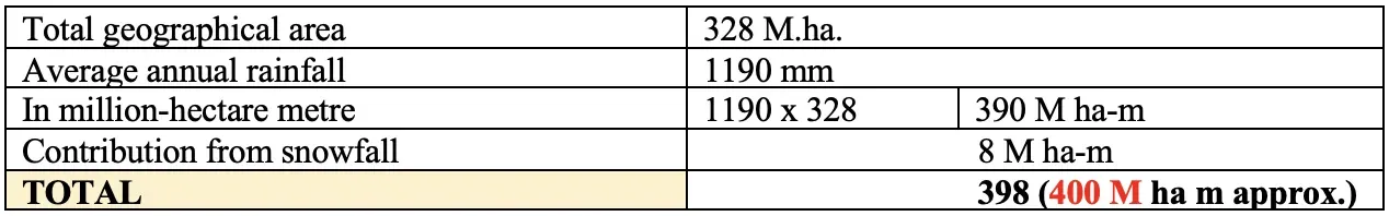
Key Facts for India's Water Budget
| Parameter | Value |
|---|---|
| Total annual rainfall | 400 M ha-m |
| Lost to evapotranspiration | 70 M ha-m |
| Surface runoff | 115 M ha-m |
| Infiltration into soil | 215 M ha-m |
| Average rainy days/year | 130 days (only 75 days effective) |
| Minimum effective rainfall | > 2.5 mm (below this, water evaporates immediately) |
| Total water availability | ~230 M ha-m (187 M ha-m surface + 43.2 M ha-m rechargeable groundwater) |
| Water availability per capita | 2300 m3/year |

TIP
Exam shortcut -- "400-70-115-215": India receives 400 M ha-m rainfall. Of this, 70 is lost to ET, 115 runs off, and 215 infiltrates. Only 230 M ha-m is ultimately available. These numbers appear frequently in competitive exams.
Agricultural relevance: With only 230 M ha-m available from 400 M ha-m of rainfall, India effectively loses over 40% of its rainfall. This is why water harvesting, efficient irrigation, and watershed management are national priorities.
Surface Runoff
- Consists of direct runoff from rainfall, snowmelt, and groundwater-fed stream flow.
- Runoff before reaching a channel is called overland flow.
- A land area draining to a common point is a watershed.
- Runoff can carry pesticides and fertilizers, causing water pollution.
- Urbanization increases runoff by creating impervious surfaces, reducing groundwater recharge.
Total surface runoff estimated by Irrigation Commission of India (1972): 115 M ha-m.

Agricultural example: In the Indo-Gangetic plains, surface runoff during heavy monsoon rains carries nitrogen and phosphorus from fertilized fields into rivers, contributing to downstream eutrophication. Conservation agriculture practices like zero tillage and residue retention reduce this runoff significantly -- studies in Haryana show 30--40% reduction in runoff with zero-till wheat.
Explore More

Summary Table
| Topic | Key Point |
|---|---|
| Hydrologic Cycle | Water is conserved -- neither created nor destroyed; 4 components: precipitation, runoff, storage, ET |
| Precipitation | Ocean evaporation provides 90% of precipitation; rainfall is the predominant form |
| Evapotranspiration | ET = E + T; determines crop water requirement |
| PET | Maximum ET under ideal moisture; used for irrigation scheduling |
| Surface Water | Easier to access; seasonal; vulnerable to contamination |
| Groundwater | Larger volume; slower recharge; more reliable year-round |
| Unconfined Aquifer | Open to atmosphere; water table; direct recharge; shallower |
| Confined Aquifer | Under artesian pressure; impermeable layers above and below; deeper |
| India's Water Budget | 400 M ha-m rainfall; 230 M ha-m available; 2300 m3/capita/year |
| Effective rainfall | > 2.5 mm; only 75 of 130 rainy days are effective |
| Surface runoff | 115 M ha-m; carries pollutants; reduced by conservation agriculture |
| Water conservation principle | Total water on Earth is constant; only form and location change |
TIP
Next: Lesson 02 covers Irrigation -- the principles, soil-water relationships (field capacity, wilting point), and scientific concepts behind managing water application to crops.
Summary Cheat Sheet
| Concept / Topic | Key Details / Explanation |
|---|---|
| Hydrologic Cycle | Continuous movement of water; 4 components: Precipitation, Runoff, Storage, Evapotranspiration |
| Water Conservation Principle | Total water on Earth is constant; only form and location change |
| Precipitation | Predominant form is rainfall; 90% of precipitation moisture comes from ocean evaporation |
| Effective Rainfall | Rain > 2.5 mm; only 75 of 130 rainy days are effective |
| Evapotranspiration (ET) | ET = Evaporation + Transpiration; determines crop water requirement |
| Potential Evapotranspiration (PET) | Maximum ET under ideal moisture conditions; used for irrigation scheduling |
| Surface Water | Easier to access; seasonal availability; vulnerable to contamination |
| Groundwater | Larger volume; slower recharge; more reliable year-round supply |
| Unconfined Aquifer | Open to atmosphere; has a water table; recharged directly from above; shallower |
| Confined Aquifer | Trapped between impermeable layers; under artesian pressure; deeper |
| India's Water Budget -- Rainfall | 400 M ha-m total annual rainfall |
| India's Water Budget -- ET | ~70 M ha-m lost to evapotranspiration |
| India's Water Budget -- Runoff | 115 M ha-m surface runoff |
| India's Water Budget -- Infiltration | 215 M ha-m infiltrates into soil/groundwater |
| India's Water Budget -- Available | 230 M ha-m total available water |
| Per Capita Water Availability | ~2300 m³/capita/year |
| Surface Runoff | Carries pollutants; reduced by conservation agriculture practices |