🌲 Terai & Bhabar — The Northern Frontier
A clearer explanation of Uttar Pradesh's Bhabar and Terai belts, covering their formation, water behavior, districts, wildlife, Tharu connection, and agricultural importance.
Introduction
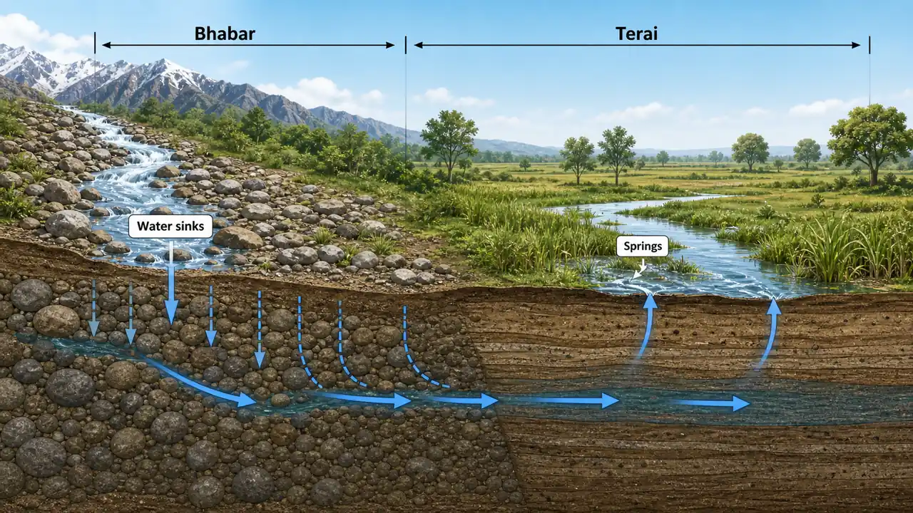
The northernmost strip of Uttar Pradesh, along the Indo-Nepal border, contains two closely linked but very different zones: Bhabar and Terai. Students often memorize the names but mix up their behavior. The simplest way to separate them is through water:
- in Bhabar, water tends to sink
- in Terai, that water tends to reappear
These belts are important not only for physical geography, but also for wildlife, border districts, agriculture, and tribal communities.
How Bhabar & Terai Formed
As rivers descend from the Himalayas onto the plains, they lose velocity and deposit their load in a specific sequence:
- Heavy material first — boulders, pebbles, gravel deposited at the foothills = Bhabar zone
- Finer material further south — silt, clay deposited where water re-emerges = Terai zone
This process has been ongoing for millions of years, creating two parallel belts with dramatically different characteristics.
Bhabar Zone (भाबर)
| Feature | Detail |
|---|---|
| Width | 8–16 km (narrow strip) |
| Location | Immediately south of Shivalik Hills |
| Composition | Pebbles, boulders, coarse gravel |
| Porosity | Extremely high — streams disappear underground |
| Water table | Very deep |
| Vegetation | Sparse; dry deciduous scrub |
| Population | Very sparse |
| Agriculture | Poor without irrigation; soil too porous |
Why Streams Disappear
The coarse gravel and boulder deposits in the Bhabar zone are so porous that surface water simply percolates through them. Rivers and streams flowing from the Himalayas literally vanish into the ground upon entering the Bhabar belt. This underground water travels southward through the porous substrate and eventually re-emerges in the Terai zone.
This one process is the key to the whole lesson. If a student remembers only this contrast, many later facts become easier:
- Bhabar = coarse, porous, drier surface
- Terai = wetter, marshier, more fertile after reclamation
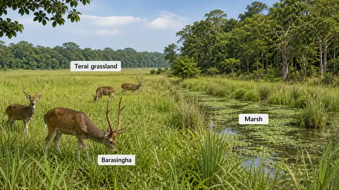
Terai Zone (तराई)
| Feature | Detail |
|---|---|
| Width | 15–30 km |
| Location | South of Bhabar |
| Composition | Fine silt, clay, organic matter |
| Water | Abundant — underground streams re-emerge as springs |
| Terrain | Marshy, waterlogged, low-lying |
| Vegetation | Dense tropical moist deciduous + tall grasslands |
| Agriculture | Highly fertile after drainage and reclamation |
Terai Reclamation
After Independence, the Government of India launched major Terai reclamation programs in the 1950s–60s:
- Dense forests cleared and marshes drained
- Canals and drainage systems built
- Settlers from different parts of India brought in
- Region transformed into a major rice and sugarcane producing belt
This is why the Terai should not be imagined as only forest and swamp. Historically it had extensive marshy and forest conditions, but large parts were later converted into productive agricultural land.
Key Districts of the Terai-Bhabar Belt
| District | Division | Special Feature |
|---|---|---|
| Lakhimpur Kheri | Lucknow | Largest district of UP by area; Dudhwa NP |
| Pilibhit | Bareilly | Pilibhit Tiger Reserve; Indo-Nepal border |
| Bahraich | Ayodhya | Katarniaghat Wildlife Sanctuary |
| Shravasti | Ayodhya | Buddhist pilgrimage; border district |
| Balrampur | Ayodhya | Forested; sugarcane belt |
| Maharajganj | Gorakhpur | Border district; rice production |
| Siddharthnagar | Basti | Named after Gautam Buddha (Siddhartha) |
These districts are worth learning together because they connect multiple UP GK themes at once:
- Nepal border
- wetlands and forests
- rice and sugarcane cultivation
- wildlife reserves
- tribal and cultural diversity
Dudhwa National Park
| Parameter | Detail |
|---|---|
| Location | Lakhimpur Kheri district |
| Established | 1977 (National Park); Tiger Reserve since 1987 |
| Area | ~490 sq km (core zone) |
| Key Species | Barasingha (Swamp Deer — UP State Animal), Royal Bengal Tiger, Indian Rhinoceros (reintroduced) |
| Ecosystem | Terai grasslands + moist deciduous forest |
| Unique | One of the few habitats of the hispid hare (endangered) |
Dudhwa is part of the larger Terai Arc Landscape — a wildlife corridor connecting protected areas of India and Nepal.
Pilibhit Tiger Reserve
| Parameter | Detail |
|---|---|
| Location | Pilibhit district |
| Established | 2014 (Tiger Reserve) |
| Area | ~730 sq km |
| Recognition | TX2 Award (2020) — for doubling tiger numbers |
| Ecosystem | Terai sal forest + grasslands + swamps |
Tharu Tribe (थारू जनजाति)
The Tharu are the most prominent tribal community of the Terai region.
| Feature | Detail |
|---|---|
| Habitat | Terai belt — Lakhimpur Kheri, Bahraich, Balrampur, Shravasti, Pilibhit |
| Population | Largest Scheduled Tribe in UP |
| Language | Tharu language (Indo-Aryan family) |
| Livelihood | Agriculture (rice, wheat), fishing, forest produce |
| Culture | Distinct festivals, folk dances, bamboo crafts |
| Health | Often discussed in older geography/GK material in relation to relative malaria tolerance/adaptation |
| Government scheme | PM Van Dhan Yojana, Forest Rights Act benefits |
For exam use, the safest memory is: Tharu = Terai tribe of northern UP, especially linked with forest-edge and border districts.
Agriculture in Terai-Bhabar
Major Crops
| Season | Crops |
|---|---|
| Kharif | Rice (paddy) — dominant crop, maize |
| Rabi | Wheat, mustard, lentils |
| Cash crops | Sugarcane (major), banana, litchi |
Agricultural Advantages
- Deep, fertile alluvial and clayey soil (Terai)
- Abundant water from rivers and high water table
- High rainfall (120–180 cm annually)
- Long growing season
Agricultural Challenges
- Waterlogging and marshy patches persist
- Flooding from Himalayan rivers during monsoon
- Wildlife-human conflict near forest areas
- Remote location — market access limited
This final contrast is useful for revision:
- Bhabar is harder for agriculture because water disappears into coarse deposits
- Terai is better for agriculture after drainage, but it also faces flooding and waterlogging
Summary Cheat Sheet
| Term | Quick Recall |
|---|---|
| Bhabar width | 8–16 km |
| Bhabar key feature | Streams vanish underground (porous gravel) |
| Terai width | 15–30 km |
| Terai key feature | Marshy; streams re-emerge |
| Largest UP district | Lakhimpur Kheri |
| Dudhwa NP | Lakhimpur Kheri; Barasingha, Tiger, Rhino |
| Pilibhit TR award | TX2 Award 2020 (tiger doubling) |
| Tharu tribe | Largest ST in UP; malaria resistance |
| Dominant Kharif crop | Rice |
| Major cash crop | Sugarcane |
| Annual rainfall | 120–180 cm |
Lesson Doubts
Ask questions, get expert answers