🌦️ Climate of UP — Seasons & Rainfall
An exam-focused explanation of Uttar Pradesh's subtropical monsoon climate, including seasons, rainfall gradient, Loo, fog, winter rain, and the major regional climate contrasts students should remember.
Introduction
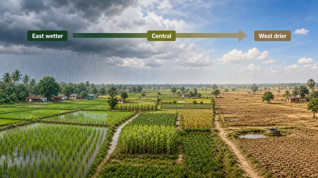
Uttar Pradesh has a subtropical monsoon climate with strong seasonal contrasts. The easiest way to understand UP climate is not by isolated numbers, but by regional patterns:
- western UP and Bundelkhand are hotter and relatively drier
- eastern UP is wetter and more flood-prone
- winter fog is a major Gangetic plain feature
- Loo and Mahawat are classic exam terms tied to summer and winter
The state's wide east-west spread and varied physical regions create significant climatic differences even within the same state.
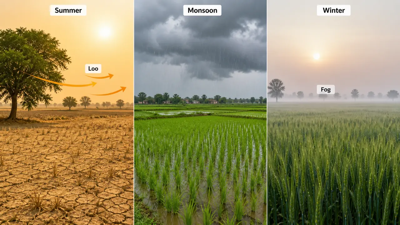
Three Seasons of UP
| Season | Hindi Name | Months | Key Feature |
|---|---|---|---|
| Summer (ग्रीष्म) | गर्मी | March – June | Extreme heat; Loo winds |
| Monsoon / Rainy (वर्षा) | बरसात | July – September | SW monsoon; bulk of annual rain |
| Winter (शीत) | सर्दी / जाड़ा | October – February | Cold waves; dense fog |
Summer Season (March – June)
Temperature Pattern
| Month | Western UP | Eastern UP | Bundelkhand |
|---|---|---|---|
| March | 30–35°C | 28–33°C | 32–37°C |
| April | 36–40°C | 34–38°C | 38–42°C |
| May | 40–45°C | 36–42°C | 42–47°C |
| June | 40–46°C | 36–40°C | 44–48°C |
Loo Winds (लू)
- Hot, dry westerly winds that blow across the plains from May to mid-June
- Originate from the Thar Desert (Rajasthan) and travel eastward
- Temperature during Loo can exceed 45°C
- Most severe in western UP and Bundelkhand (Agra, Jhansi, Banda)
- Health hazard — causes heatstroke and dehydration
- Intensity decreases as winds move eastward due to moisture gain
For exam memory, think of Loo as the signature summer wind of the north Indian plains. UP questions usually test where it is strongest and what kind of weather it produces.
Heat Wave Records
| Location | Notable Temperature | Remark |
|---|---|---|
| Banda | ~48°C | Among the hottest in UP |
| Jhansi | ~47°C | Consistently extreme summers |
| Agra | ~46°C | Western UP heat belt |
| Lucknow | ~44°C | Central UP |
| Gorakhpur | ~42°C | Eastern UP (relatively cooler) |
Monsoon / Rainy Season (July – September)
The Southwest Monsoon (दक्षिण-पश्चिम मानसून) is the primary source of rainfall in UP. In simple exam language, UP receives monsoon influence mainly through the Bay of Bengal branch, which is why eastern UP usually gets rain earlier and in greater quantity than the west.
Monsoon Arrival
| Event | Approximate Date |
|---|---|
| Monsoon reaches eastern UP | Usually around the second half of June |
| Covers entire UP | Early to mid-July |
| Monsoon withdrawal begins | Mid-September (western UP first) |
| Complete withdrawal | Early October |
Rainfall Distribution — East to West Gradient
This is one of the most important exam facts about UP's climate:
| Region | Annual Rainfall | Remark |
|---|---|---|
| Eastern UP (Gorakhpur, Bahraich) | 150–170 cm | Highest — closer to monsoon source |
| Central UP (Lucknow, Kanpur) | 100–120 cm | Moderate |
| Western UP (Agra, Mathura) | 84–90 cm | Lowest — monsoon weakens westward |
| Bundelkhand (Jhansi, Banda) | 75–100 cm | Erratic; drought-prone |
Rainfall decreases from east to west — this gradient is a frequently asked exam fact.
Monsoon Characteristics
- ~75–85% of annual rainfall occurs during monsoon months
- Distribution is uneven — causes both floods (east) and droughts (Bundelkhand)
- Break monsoon periods (dry spells within monsoon) can severely damage Kharif crops
- Eastern UP rivers (Ghaghra, Rapti, Gandak) flood regularly during heavy monsoon years
This is one of the most useful climate contrasts in the whole course:
- east: more rainfall, more flood risk
- west: less rainfall
- Bundelkhand: erratic rainfall, stronger drought tendency
Winter Season (October – February)
Temperature Pattern
| Month | Western UP | Eastern UP | Bundelkhand |
|---|---|---|---|
| November | 18–22°C | 20–24°C | 19–23°C |
| December | 12–17°C | 14–18°C | 13–17°C |
| January | 3–15°C | 6–17°C | 5–16°C |
| February | 8–20°C | 10–22°C | 9–21°C |
Winter Rainfall (Mahawat / मावठ)
- Caused by Western Disturbances (extratropical cyclones from the Mediterranean)
- Brings 5–10% of annual rainfall
- Occurs mainly in January–February
- Called "Mahawat" locally
- Extremely beneficial for Rabi crops (wheat, mustard, gram)
Students often overlook this because winter is thought of as a dry season. But in north Indian agriculture, this light winter rain can be very beneficial when it arrives at the right time.
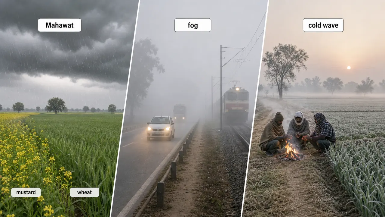
Dense Fog (कोहरा)
- December and January bring dense fog across the Gangetic Plain
- Visibility drops to near zero in severe episodes
- Major disruptions to road, rail, and air transport
- Delhi-Lucknow-Varanasi corridor most affected
- Causes crop damage — delays wheat flowering, promotes fungal diseases
Cold Waves (शीत लहर)
- Occur when cold air from Central Asia pushes southward
- Minimum temperatures can drop to 1–3°C in western UP
- Districts most affected: Meerut, Agra, Muzaffarnagar, Lucknow
- IMD issues cold wave warnings when temperature drops 4.5°C below normal
Climate Data Summary Table
| Parameter | Value |
|---|---|
| Climate type | Subtropical Monsoon (Cwa — Koppen) |
| Annual rainfall range | 84 cm (west) to 170 cm (east) |
| Hottest month | May–June |
| Coldest month | January |
| Highest recorded temp | ~48°C (Banda region) |
| Lowest recorded temp | ~1°C (western UP, January) |
| Monsoon months | July–September |
| Winter rain name | Mahawat (from Western Disturbances) |
Climate Change Impacts on UP
This topic is real and important, but exact long-term trend numbers can change depending on the dataset and period used. For a stable lesson, it is safer to remember the broad direction:
| Impact | Broad Pattern |
|---|---|
| Rising temperatures | Heat stress is increasing across many parts of the Indo-Gangetic region |
| Erratic monsoon | Rain may come in more uneven or intense spells |
| Heat waves | Hotter conditions especially stress western UP and Bundelkhand |
| Groundwater stress | Higher evaporation and irrigation demand can worsen pressure |
| Crop vulnerability | Wheat and other seasonal crops are sensitive to temperature stress |
Summary Cheat Sheet
| Term | Quick Recall |
|---|---|
| Climate type | Subtropical Monsoon (Cwa) |
| Loo winds | Hot, dry westerly; May–June; from Thar |
| Hottest areas | Banda, Jhansi (~47–48°C) |
| Highest rainfall | Eastern UP (150–170 cm) |
| Lowest rainfall | Western UP, Agra belt (84–90 cm) |
| Monsoon entry | Mid-June (eastern UP first) |
| Monsoon share | 75–85% of annual rain |
| Mahawat | Winter rain from Western Disturbances |
| Fog months | December–January |
| Coldest temp | ~1–3°C in western UP (January) |
Lesson Doubts
Ask questions, get expert answers