🌳 Forest Cover of UP
Forest cover statistics, types of forests, district-wise distribution, ISFR data, social forestry, and agroforestry initiatives in Uttar Pradesh for Uttar Pradesh GK.
Forest Cover — The Big Picture
Uttar Pradesh has one of the lower forest-cover percentages among Indian states. According to the India State of Forest Report (ISFR) 2023 — the latest official FSI baseline available as of June 3, 2026 — UP's total forest cover is approximately 14,806 sq km, constituting just ~6.15% of the state's geographic area.
This is dramatically below the national average of 21.71% and far from the National Forest Policy 1988 target of 33% forest cover for the country.
The easiest way to understand this lesson is through one contrast:
- UP is a big agricultural plains state
- so its legal forest area and actual forest cover are both limited
- the best forested zones are mainly in the Terai belt and the southern Vindhyan-Sonbhadra region
| Parameter | Value |
|---|---|
| Total Geographic Area | 2,40,928 sq km |
| Total Forest Cover | ~14,806 sq km |
| Forest Cover % | ~6.15% |
| National Average | 21.71% |
| National Policy Target | 33% |
| Recorded Forest Area (RFA) | ~16,583 sq km (6.88%) |
| Tree Cover (outside forests) | ~8,625 sq km |
Exam Tip: Distinguish between forest cover (actual canopy detected by satellite) and recorded forest area (land legally classified as forest). RFA is always slightly higher than actual forest cover.
Types of Forests in UP
UP's forests are classified into three major types based on climate, rainfall, and altitude:
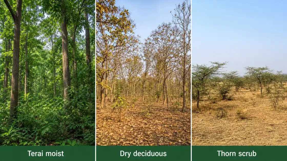
1. Tropical Dry Deciduous Forests
This is the most widespread forest type in UP, covering the Vindhyan hills, Bundelkhand plateau, and parts of central UP.
| Feature | Details |
|---|---|
| Extent | Largest forest type in UP |
| Location | Mirzapur, Sonbhadra, Banda, Chitrakoot, Hamirpur |
| Rainfall Zone | 750–1,200 mm |
| Key Species | Teak (Sagwan), Tendu, Mahua, Palash, Khair |
| Characteristics | Trees shed leaves in hot season (March–May) |
2. Tropical Moist Deciduous Forests
Found in the Terai belt along UP's northern border with Nepal, where higher rainfall and proximity to the Himalayas create moist conditions.
| Feature | Details |
|---|---|
| Location | Lakhimpur Kheri, Pilibhit, Bahraich, Shravasti, Balrampur |
| Rainfall Zone | 1,200–2,000 mm |
| Key Species | Sal (Shorea robusta), Sheesham, Teak, Bamboo, Jamun |
| Characteristics | Dense canopy, rich undergrowth, high biodiversity |
| Notable Area | Dudhwa National Park ecosystem |
3. Tropical Thorn Forests
Found in the semi-arid western UP districts bordering Rajasthan, where rainfall drops below 750 mm.
| Feature | Details |
|---|---|
| Location | Agra, Mathura, western fringes |
| Rainfall Zone | < 750 mm |
| Key Species | Babool (Acacia), Ber, Cactus, Khejri |
| Characteristics | Thorny bushes, scattered trees, open canopy |
District-wise Forest Distribution
Forest cover is extremely uneven across UP's 75 districts. The southern and Terai districts have the most, while the Gangetic plain districts are almost treeless.
Districts with Highest Forest Cover
| District | Forest Area (sq km) | % of District Area |
|---|---|---|
| Sonbhadra | ~2,540 | 36.79% |
| Mirzapur | ~1,295 | 28.94% |
| Lakhimpur Kheri | ~860 | 11.04% |
| Pilibhit | ~740 | 20.95% |
| Chitrakoot | ~630 | 15.68% |
Districts with Lowest Forest Cover
| District | Forest Area (sq km) | % of District Area |
|---|---|---|
| Sant Ravidas Nagar | ~3.12 | 0.31% |
| Deoria | ~5.2 | 0.21% |
| Mau | ~4.8 | 0.22% |
| Ballia | ~8.5 | 0.26% |
The exact district numbers can change slightly between report cycles, but the durable exam pattern is stable:
- Sonbhadra is the forest-rich district of UP
- densely cultivated eastern/plain districts have extremely low forest cover
Exam Tip: Sonbhadra = highest forest-rich district in UP. Sant Ravidas Nagar is commonly cited among the lowest forest-cover districts in standard UP GK material.
ISFR Data and Trends
The India State of Forest Report (ISFR) is published biennially by the Forest Survey of India (FSI), Dehradun. It uses satellite imagery to assess forest cover across India.
| ISFR Category | Definition | UP Coverage |
|---|---|---|
| Very Dense Forest | Canopy > 70% | ~1,040 sq km |
| Moderately Dense Forest | Canopy 40–70% | ~3,890 sq km |
| Open Forest | Canopy 10–40% | ~9,876 sq km |
| Scrub | Canopy < 10% | ~1,100 sq km |
The bulk of UP's forest is open forest — degraded woodland with thin canopy — rather than dense, ecologically rich forest. This is an important interpretation point: UP's forest problem is not only low area, but also lower ecological quality across much of that area.
Recent Trends
- UP's forest cover has shown marginal improvement in recent ISFR cycles
- Gains are primarily from plantation activities and agroforestry, not natural forest regeneration
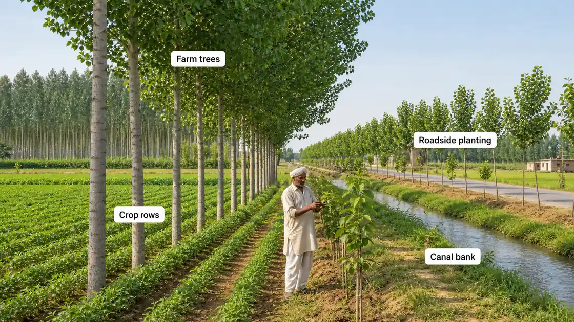
- Tree cover outside forests (~8,625 sq km) is significant — reflecting roadside, canal-side, and farm tree planting
Social Forestry and Agroforestry
Given its low natural forest cover, UP has pursued social forestry and agroforestry as strategies to increase green cover.
Social Forestry Programme
Launched in the 1980s, social forestry aims to plant trees on non-forest lands — roadsides, canal banks, wasteland, and community lands.
| Component | Description |
|---|---|
| Farm Forestry | Trees on private agricultural land |
| Community Forestry | Plantation on common/panchayat land |
| Extension Forestry | Along roads, railways, canals |
| Urban Forestry | Greening cities and towns |
Agroforestry Promotion
UP has emerged as a leading agroforestry state. Farmers grow timber and fruit trees alongside crops — poplar, eucalyptus, and mango are the most common agroforestry species.
| Species | Region | Economic Value |
|---|---|---|
| Poplar (Populus) | Western UP (Saharanpur, Muzaffarnagar) | Plywood, matchstick industry |
| Eucalyptus | Central and eastern UP | Pulp, paper, essential oils |
| Mango | Lucknow, Malihabad, Saharanpur | Fruit, timber |
| Teak | Southern UP (Vindhyan) | High-value timber |
Exam Tip: Poplar cultivation in western UP is a major agribusiness — trees mature in 6–8 years and supply the plywood industry centred around Yamunanagar (Haryana).
Government Initiatives
| Initiative | Purpose |
|---|---|
| Van Mahotsav | Annual tree planting festival (July) |
| Compensatory Afforestation (CAMPA) | Mandatory plantation when forest land is diverted |
| Green India Mission | National mission to increase forest cover |
| UP State Forestry Action Plan | State-level strategy for forest management |
| Joint Forest Management (JFM) | Community participation in forest protection |
Summary Cheat Sheet
| Item | Quick Fact |
|---|---|
| Forest Cover (ISFR 2023) | ~14,806 sq km (~6.15%) |
| National Average | 21.71% |
| Largest Forest Type | Tropical Dry Deciduous |
| Terai Forests | Moist Deciduous (Sal, Sheesham) |
| Highest Forest District | Sonbhadra |
| Very low forest-cover districts | Sant Ravidas Nagar, Deoria, Mau, Ballia type plain districts |
| Key Agroforestry | Poplar (western UP), Eucalyptus |
| ISFR Publisher | Forest Survey of India, Dehradun |
Lesson Doubts
Ask questions, get expert answers