🗺️ UP — The State Profile
A foundational profile of Uttar Pradesh covering its naming history, area, population baseline, capital, languages, state symbols, emblem, and exam-critical national rankings.

Whenever an exam asks about Uttar Pradesh in a one-line format, it is usually testing whether you can connect identity facts together: when the state got its present name, where its institutions sit, what symbols represent it, and why it ranks so prominently in India. This lesson builds that base carefully, because later geography, polity, agriculture, and economy questions all depend on it.
Formation & Identity
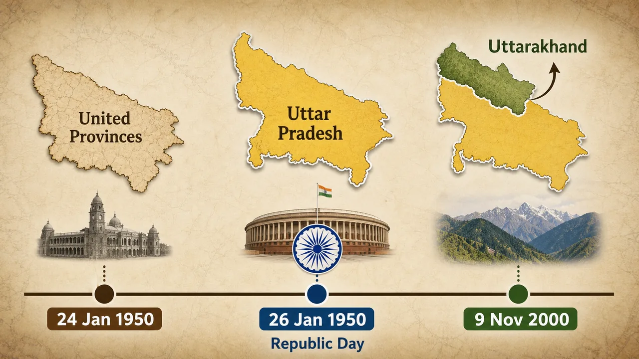
The present name Uttar Pradesh dates from 24 January 1950, when the former United Provinces was officially renamed. This is why 24 January is observed as Uttar Pradesh Divas.
This detail matters because many students mix it up with 26 January 1950, the date on which the Constitution of India came into force and India became a Republic. In exam language, the safer statement is:
- 24 January 1950 → United Provinces renamed as Uttar Pradesh
- 26 January 1950 → Constitution came into force; India became a Republic
Exam Tip: If a question asks for the "formation day" or "state day" of Uttar Pradesh, answer 24 January. If it asks about India's Republic Day, answer 26 January.
On 9 November 2000, the hill region of undivided Uttar Pradesh was separated to form Uttarakhand. This reduced the size of the old state and shaped the present territorial profile of UP.
| Fact | Detail |
|---|---|
| Earlier Name | United Provinces |
| Present Name Adopted | 24 January 1950 |
| State Day | Uttar Pradesh Divas on 24 January |
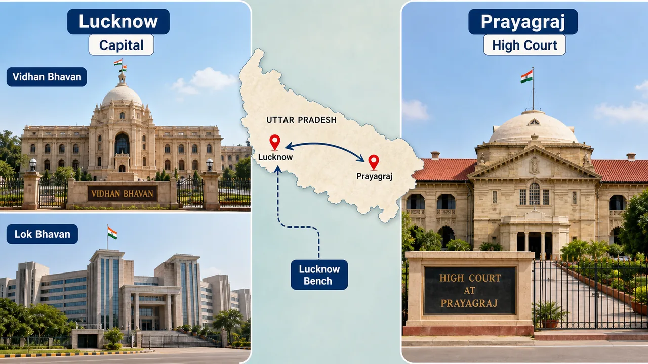
| Capital | Lucknow (लखनऊ) |
| High Court | Prayagraj (प्रयागराज), Bench at Lucknow |
| Official Language | Hindi |
| Second Official Language | Urdu |
Area & Geographical Position
Uttar Pradesh covers a total area of 2,40,928 sq km, making it the 4th largest state in India by area (after Rajasthan, Madhya Pradesh, and Maharashtra). This area constitutes roughly 7.33% of India's total geographical area.
Geographical Coordinates
| Parameter | Value |
|---|---|
| Latitude | 23°52'N to 31°28'N |
| Longitude | 77°31'E to 84°39'E |
| Maximum Length (East-West) | ~650 km |
| Maximum Breadth (North-South) | ~240 km |
The state is entirely landlocked. Physiographically, most of it lies in the Gangetic plain, while the Terai belt marks the northern foothill zone and the Vindhyan uplands appear toward the south. This is why later UP GK lessons repeatedly connect state identity with rivers, fertile alluvium, and very high population pressure.
Population & National Rankings
By the Census 2011 baseline, Uttar Pradesh had a population of 19,95,81,477, making it the most populous state in India. Many modern discussions say UP's population is now above 24 crore, but for exam safety you should treat Census 2011 as the official benchmark unless a question explicitly uses estimates or projections.
| Ranking Parameter | UP's Rank in India |
|---|---|
| Population | 1st |
| Area | 4th |
| Number of Districts | Among the highest (75) |
| Lok Sabha Seats | 1st (80 seats) |
| Vidhan Sabha Strength | Largest among states |
Two ranking facts are especially important:
- UP sends the highest number of members to the Lok Sabha: 80
- UP is often called politically decisive because national governments are strongly influenced by outcomes in the state
For assembly-related questions, remember that current exam material should be read carefully because older books may still mention the earlier nominated Anglo-Indian seat convention.
Capital City — Lucknow
Lucknow (लखनऊ) serves as both the state capital and the administrative headquarters. Known historically as the city of Nawabs and for its tehzeeb (etiquette), Lucknow is also a major educational and industrial hub.
The Vidhan Bhavan (state legislature complex) and the Lok Bhavan (Chief Minister's office) are both situated in Lucknow. The Allahabad High Court, however, has its principal seat in Prayagraj, with a bench in Lucknow.
State Symbols
State symbols are extremely important for one-liner questions in UPSSSC exams. The exam usually asks them in direct recall format, but learning the habitat or cultural link behind each symbol makes them easier to retain.
| Symbol | Name | Scientific / Hindi Name |
|---|---|---|
| State Animal | Barasingha (Swamp Deer) | Rucervus duvaucelii (बारहसिंगा) |
| State Bird | Sarus Crane | Antigone antigone (सारस) |
| State Tree | Ashoka Tree | Saraca asoca (अशोक) |
| State Flower | Palash (Flame of the Forest) | Butea monosperma (पलाश / ढाक) |
| State Fish | Moh / Chital | Chitala chitala (मोह / चितल) |
| State Dance | Kathak | Classical dance originating from temple storytelling (कथक) |
| State Sport | Field Hockey | (हॉकी) |
Key Details About State Symbols
- Barasingha literally means "twelve-horned" — the antlers can have 10-14 tines. It is found primarily in the marshy grasslands of Dudhwa National Park in Lakhimpur Kheri district.

- Sarus Crane is the tallest flying bird in the world. UP has the largest population of Sarus Cranes globally, particularly in the wetlands of eastern UP.

- Palash blooms in bright orange-red during spring and is often linked with the seasonal color memory used in Holi-related cultural references.

State Emblem
The official emblem of Uttar Pradesh features two fish and an arrow (bow and arrow), enclosed within a circular border. The emblem is used on all official state documents and correspondence.
Emblem Symbolism in Detail
- Confluence of Ganga-Yamuna at Prayagraj — the emblem represents the sacred Sangam (confluence) of the Ganga and Yamuna rivers at Prayagraj, symbolizing the spiritual and cultural heart of the state.
- Pair of Matsya (Fish) — the two fish (Matsya) are inherited from the Nawabs of Awadh legacy. The fish motif (Mahi Maratib) was a symbol of royal authority in the Awadh court.
- Bow & Arrow — the bow and arrow symbolize Lord Ram and the city of Ayodhya, representing the martial and dharmic heritage of the region.
Exam Tip: Do not confuse the state emblem with the national emblem (Lion Capital of Ashoka). Questions often test whether candidates can distinguish between the two.
Summary Cheat Sheet
| Item | Quick Fact |
|---|---|
| Present Name Adopted | 24 Jan 1950 (renamed from United Provinces) |
| Republic Day Reminder | India became a Republic on 26 Jan 1950 |
| Area | 2,40,928 sq km (4th in India, 7.33%) |
| Population Baseline | Census 2011: 19,95,81,477 |
| Population Rank | 1st in India |
| Capital | Lucknow |
| Coordinates | 23°52'N–31°28'N, 77°31'E–84°39'E |
| State Animal | Barasingha (Swamp Deer) |
| State Bird | Sarus Crane |
| State Tree | Ashoka |
| State Flower | Palash (Flame of the Forest) |
| State Fish | Chital / Moh |
| State Dance | Kathak (classical, temple storytelling origin) |
| State Sport | Field Hockey |
| State Emblem | Two fish (Nawabs of Awadh) + bow-arrow (Lord Ram, Ayodhya) |
| Lok Sabha Seats | 80 (highest in India) |
| Uttarakhand Carved Out | 9 November 2000 |
Lesson Doubts
Ask questions, get expert answers