⛰️ Bundelkhand & the Vindhyan Region
A clearer guide to southern Uttar Pradesh, explaining Bundelkhand and the Vindhyan region through terrain, ravines, minerals, water scarcity, Ken-Betwa, and agriculture under drought-prone conditions.
Introduction
Southern Uttar Pradesh looks very different from the fertile Gangetic Plain. This is the part of UP where hard rock, thin soil, ravines, water scarcity, and drought become major themes. So if the plain represents fertility and dense settlement, Bundelkhand and the Vindhyan belt represent scarcity, ruggedness, and adaptation.
This lesson is easiest to understand if you hold four ideas together:
- the land is older and rockier
- water is harder to store
- some pockets are mineral-rich
- history and geography are closely linked here
Bundelkhand — The Seven Districts
Bundelkhand in UP comprises 7 districts, forming a distinct socio-geographic unit.
| District | Division | Notable Feature |
|---|---|---|
| Jhansi | Jhansi | Divisional HQ; Rani Lakshmibai fort |
| Lalitpur | Jhansi | Deogarh temple (Gupta-era) |
| Jalaun | Jhansi | Orai is the district HQ |
| Hamirpur | Chitrakoot | Smallest district by population in region |
| Mahoba | Chitrakoot | Chandela dynasty temples and tanks |
| Banda | Chitrakoot | Hottest temperatures in UP |
| Chitrakoot | Chitrakoot | Sacred pilgrimage; Lord Ram's exile |
Bundelkhand extends into Madhya Pradesh as well (6 districts), making it a total of 13 districts across both states.
In exam preparation, students should not treat Bundelkhand only as a district list. It is also a problem region associated with drought, outmigration, tank systems, and repeated development packages.
Vindhyan Plateau — Physical Characteristics
The Vindhyan Plateau is part of India's ancient peninsular shield, with rocks dating back to the Precambrian and Proterozoic eras (over 600 million years old).
Terrain Features
| Feature | Detail |
|---|---|
| Rock Type | Sandstone, limestone, granite, gneiss |
| Elevation | 300–600 m above sea level |
| Terrain | Undulating; plateau with scattered hills |
| Ravines | Extensive along Yamuna, Chambal, and Ken rivers |
| Soil Depth | Thin — 15–50 cm over bedrock |
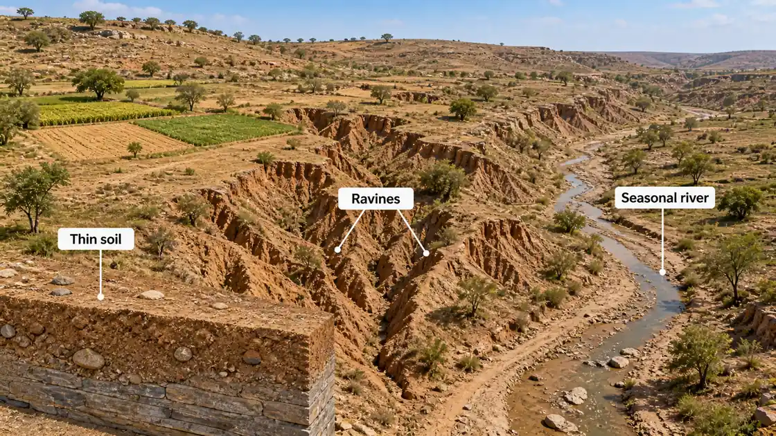
Ravine Problem
- Ravines (बीहड़) are deep gullies formed by soil erosion along river banks
- Large areas of land in the Yamuna-Chambal belt are affected by ravine erosion
- Most severe along the Yamuna and Chambal in Agra, Etawah, and Jalaun
- Reclamation efforts include check dams, contour bunding, and afforestation
The key idea is not the exact figure but the effect: ravines break the land into steep gullies, reduce cultivable area, increase runoff, and make farming and road connectivity harder.
Mineral Wealth — Sonbhadra & Mirzapur
While most of UP lacks significant minerals, the Sonbhadra-Mirzapur belt in the Vindhyan region is an exception.
| Mineral | Location | Significance |
|---|---|---|
| Coal | Singrauli (Sonbhadra) | Only coal deposit in UP; powers thermal plants |
| Limestone | Mirzapur, Sonbhadra | Cement industry (Chunar, Dalla) |
| Bauxite | Sonbhadra | Aluminium raw material |
| Dolomite | Sonbhadra | Used in steel and glass industry |
| Silica Sand | Shankargarh (Prayagraj) | Glass manufacturing |
| Diaspore | Banda, Chitrakoot | Refractory material |
Sonbhadra is called the "Energy Capital of UP" due to multiple thermal power plants (Obra, Anpara, Renusagar).
This section matters because southern UP is not only drought-prone; it is also one of the few parts of the state where hard-rock geology creates mineral significance.
Water Scarcity — The Central Challenge
Bundelkhand is one of India's most drought-prone regions. Water scarcity affects agriculture, drinking water, and livelihoods.
Causes of Water Scarcity
- Hard-rock terrain limits easy groundwater storage and recharge
- Thin soil cannot retain moisture
- Erratic monsoon — rainfall ranges from 75 to 100 cm (lower than state average)
- Deforestation has reduced natural water retention
- Traditional water bodies (Chandela-era tanks) have silted up
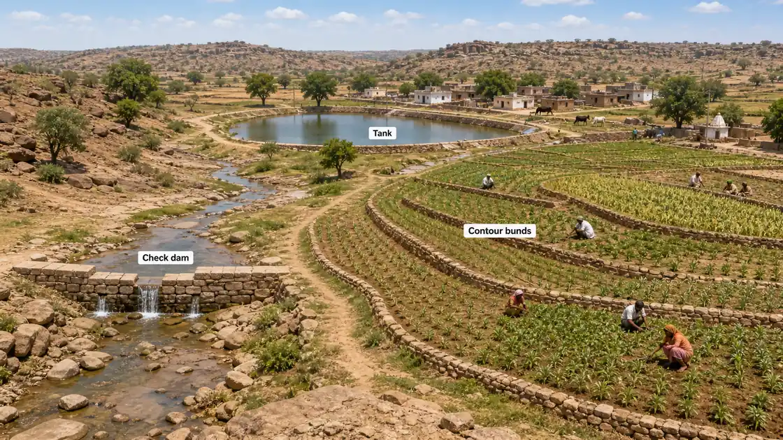
This explains why traditional tanks and modern watershed work are both important here. In Bundelkhand, the problem is often not that rain never falls, but that water runs off quickly and is not stored well.
Ken-Betwa River Link Project
| Parameter | Detail |
|---|---|
| Objective | Transfer surplus water from Ken river to water-deficit Betwa basin |
| Status | India's first river interlinking project — approved by Cabinet in 2021 |
| Daukhan Dam | Main dam on Ken river in MP |
| Beneficiary districts | Banda, Mahoba, Jhansi, Lalitpur (UP); Panna, Tikamgarh, Chhatarpur (MP) |
| Irrigation potential | ~10.62 lakh hectares (both states combined) |
| Concern | Submergence of part of Panna Tiger Reserve |
For exam memory, remember the project through a simple contrast:
- Ken is treated as the relative donor basin
- Betwa-linked areas represent the deficit side needing support
- the project is famous because it is discussed as India's first major river-link project to move ahead in this form
Bundelkhand Special Package
The Government of India has announced multiple relief packages for Bundelkhand:
| Package | Year | Amount | Focus |
|---|---|---|---|
| Bundelkhand Package I | 2009 | Rs. 7,266 crore | Drought relief, water conservation |
| Bundelkhand Package II | 2012 | Rs. 3,506 crore | Irrigation, rural livelihood |
| PM Sinchai Yojana | Ongoing | — | Micro-irrigation, watershed management |
These packages are best remembered not as isolated government amounts, but as evidence that Bundelkhand has long been treated as a special intervention zone because ordinary rainfall and irrigation patterns were not enough.
Historical Significance
Bundelkhand has a rich history linked to powerful dynasties:
| Period | Dynasty / Event | Legacy |
|---|---|---|
| 9th–13th century | Chandela Dynasty | Built Khajuraho temples (MP) and Mahoba tanks |
| 16th–18th century | Bundela Rajputs | Founded Orchha and Jhansi; gave the region its name |
| 1857 | Rani Lakshmibai | First War of Independence — Jhansi revolt |
The name "Bundelkhand" comes from the Bundela Rajput dynasty that ruled the region.
Agriculture in Bundelkhand
Challenges
- Only ~60% land is cultivable (rest is rocky/ravines/forest)
- Irrigation covers barely 30–40% of cultivated area
- Single-crop dependency on monsoon season
- Poor access to markets and cold storage
This is why Bundelkhand agriculture is usually more fragile than Gangetic Plain agriculture. Farmers face not only lower water availability but also weaker soil depth, more runoff, and fewer stable irrigation advantages.
Crop Pattern
| Season | Crops |
|---|---|
| Kharif | Jowar, bajra, sesame (til), urad, moong |
| Rabi | Wheat, gram (chana), mustard, lentils |
| Cash crops | Limited; some oilseeds |
Summary Cheat Sheet
| Term | Quick Recall |
|---|---|
| Bundelkhand districts (UP) | 7 — Jhansi, Lalitpur, Jalaun, Hamirpur, Mahoba, Banda, Chitrakoot |
| Vindhyan rock age | Precambrian (600+ million years) |
| Sonbhadra nickname | Energy Capital of UP |
| Only coal in UP | Singrauli, Sonbhadra |
| Ken-Betwa project | First river interlinking; surplus Ken to deficit Betwa |
| Chandela legacy | Temples and water tanks in Mahoba |
| Bundela legacy | Named the region; Orchha, Jhansi |
| Ravine areas | Yamuna-Chambal belt (Agra, Etawah, Jalaun) |
| Rainfall range | 75–100 cm (below UP average) |
| Hottest district | Banda |
Lesson Doubts
Ask questions, get expert answers