🌾 The Gangetic Plain — India's Breadbasket
A deeper explanation of Uttar Pradesh's Gangetic Plain, including its formation, major sub-regions, soil types, crop patterns, and the irrigation logic that makes it the state's agricultural core.
Introduction
The Gangetic Plain is the physical and agricultural heart of Uttar Pradesh. When a student hears that UP is densely populated, highly cultivated, canal-irrigated, and dominated by wheat-rice-sugarcane systems, the background is usually this plain.
The Gangetic Plain covers approximately 90% of Uttar Pradesh's total area in standard geography teaching and is one of the most fertile agricultural regions in the world. Formed by long-term alluvial deposition by the Ganga system and its tributaries, this plain supports a huge share of the state's settlements, crops, irrigation network, and market towns.
Formation & Geology
The Gangetic Plain is best understood as a river-built plain resting in a foredeep basin south of the Himalayas. As the Himalayas rose and rivers carried sediments down, enormous quantities of alluvium were spread over the basin. That is why the plain is:
- broad and gently sloping
- fertile and thickly cultivated
- rich in groundwater
- ideal for dense settlement
| Feature | Detail |
|---|---|
| Depth of alluvium | Very deep; often described as reaching around 2,000 m near the foothill side |
| Slope | Gentle — NW to SE |
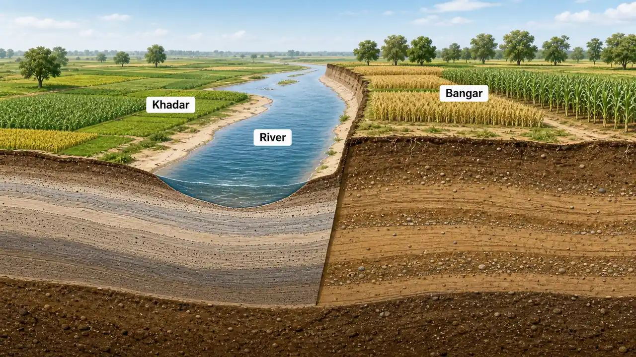
| Soil type | Alluvial — Bangar (old) and Khadar (new) |
| Groundwater | Abundant; major source of irrigation |
One idea here is especially important:
- Khadar = newer alluvium, closer to active floodplains
- Bangar = older alluvium, usually slightly higher and older surface
Sub-regions of the Gangetic Plain
The sub-regions matter because the Gangetic Plain is not identical everywhere. Rainfall, flood risk, canal history, and dominant crops shift from west to east.
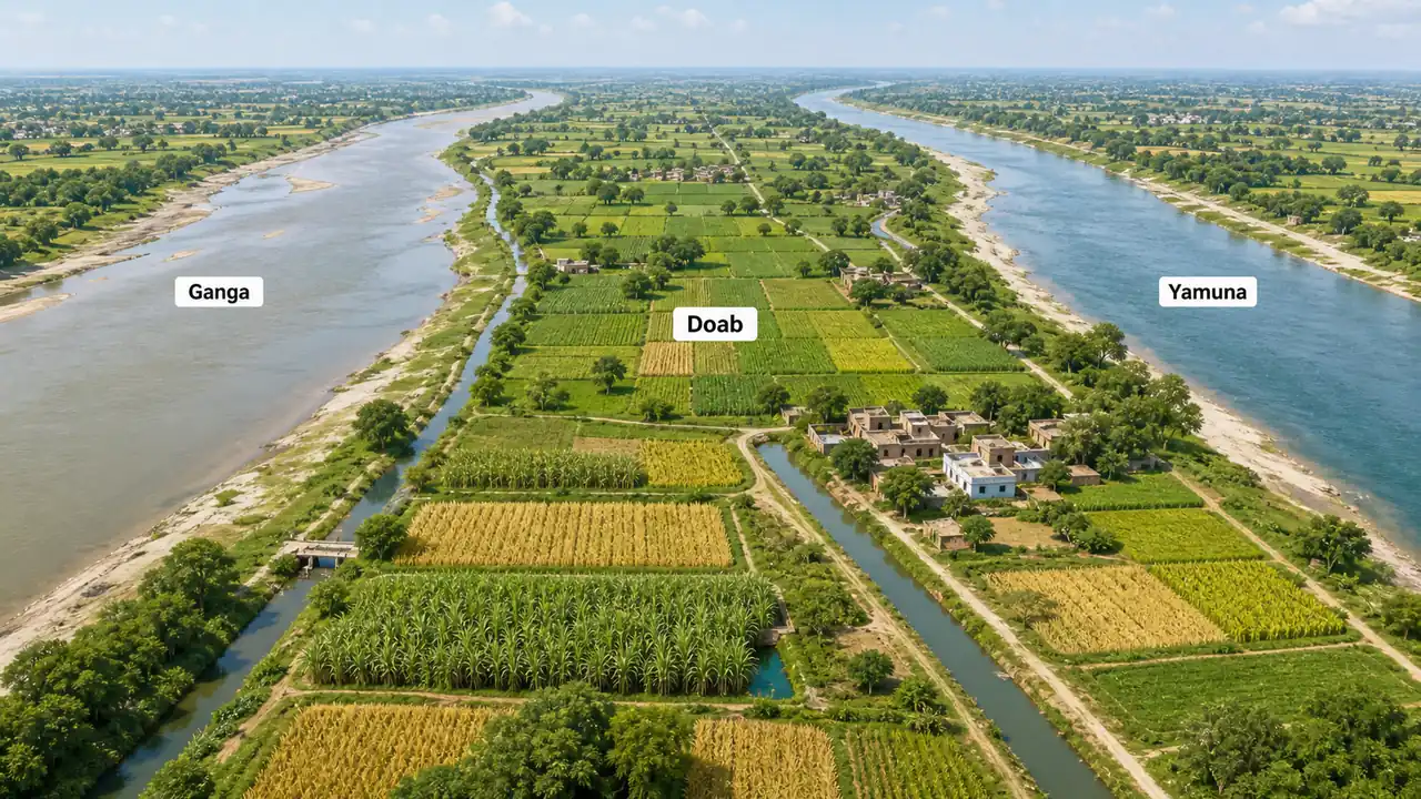
1. Upper Doab (ऊपरी दोआब)
The region between the Ganga and Yamuna rivers from Saharanpur to Aligarh.
| Parameter | Detail |
|---|---|
| Key Districts | Saharanpur, Muzaffarnagar, Meerut, Baghpat, Ghaziabad, Aligarh |
| Elevation | 250–280 m |
| Soil | New alluvium (Khadar) along rivers; Bangar on higher ground |
| Major Crops | Sugarcane, wheat, rice, vegetables |
| Irrigation | Upper Ganga Canal, Yamuna Canal; high tubewell density |
| Special Feature | Highest agricultural productivity zone in UP |
The Upper Doab is commonly associated with the "Sugar Bowl" image because of strong sugarcane cultivation, canal irrigation, and mill concentration.
2. Middle Doab (मध्य दोआब)
Stretches from Aligarh to Kanpur between Ganga and Yamuna.
| Parameter | Detail |
|---|---|
| Key Districts | Etah, Mainpuri, Farrukhabad, Kannauj, Kanpur Dehat |
| Elevation | 150–250 m |
| Soil | Mixed Bangar and Khadar; moderately fertile |
| Major Crops | Wheat, barley, potato, Kannauj roses (perfume/attar) |
| Irrigation | Lower Ganga Canal; tubewells |
| Special Feature | Transitional zone; Kannauj is the perfume capital of India |
This middle belt is useful to remember as a transition zone: it does not have the same western sugarcane dominance as the Upper Doab, and it begins moving toward more mixed agriculture and cultural specializations like Kannauj perfume.
3. Lower Doab (निचला दोआब) / Trans-Yamuna
From Kanpur to Prayagraj where the Ganga and Yamuna finally converge.
| Parameter | Detail |
|---|---|
| Key Districts | Fatehpur, Kaushambi, Prayagraj |
| Elevation | 90–150 m |
| Soil | Predominantly older alluvium (Bangar); patches of Usar soil |
| Major Crops | Wheat, gram (chickpea), pulses, oilseeds |
| Irrigation | Canal irrigation less developed; reliance on tubewells |
| Special Feature | Triveni Sangam at Prayagraj (Ganga-Yamuna-Saraswati confluence) |
In exam memory, Lower Doab is often tied less to a crop nickname and more to Prayagraj, Sangam, and older alluvial surfaces with patches of problem soils.
4. Rohilkhand Plain (रोहिलखंड मैदान)
Located north of the Ganga in the western-central part of UP.
| Parameter | Detail |
|---|---|
| Key Districts | Bareilly, Moradabad, Rampur, Shahjahanpur, Budaun, Pilibhit |
| Elevation | 150–200 m |
| Soil | Rich alluvial; well-drained loamy soil |
| Major Crops | Rice, sugarcane, wheat, mango orchards |
| Irrigation | Well-irrigated by Ramganga and tributaries; canals and tubewells |
| Special Feature | Moradabad = Brass City (Peetal Nagari); important mango-producing belt |
Rohilkhand is a useful bridge region in revision because it combines fertile alluvial agriculture with identifiable district-based GK such as Moradabad's brass industry.
5. Awadh Plain (अवध मैदान)
The central heartland of UP, historically the Awadh (Oudh) region.
| Parameter | Detail |
|---|---|
| Key Districts | Lucknow, Ayodhya, Sultanpur, Barabanki, Sitapur, Hardoi, Unnao |
| Elevation | 120–170 m |
| Soil | Deep alluvial; mix of Bangar and Khadar; some Usar patches |
| Major Crops | Wheat, rice, sugarcane, mustard, potato |
| Irrigation | Sharda Canal system; extensive tubewell network |
| Special Feature | State capital Lucknow; Ayodhya — major religious and cultural center |
Awadh is one of the easiest sub-regions to remember because political, cultural, and agricultural importance all overlap here.
6. Eastern Plain (पूर्वी मैदान)
The easternmost and wettest part of the Gangetic Plain.
| Parameter | Detail |
|---|---|
| Key Districts | Varanasi, Gorakhpur, Azamgarh, Jaunpur, Ballia, Deoria, Mau |
| Elevation | 60–100 m |
| Soil | New alluvium (Khadar); highly fertile but flood-prone |
| Major Crops | Rice is the dominant crop; jute, maize, pulses |
| Irrigation | Ghaghra, Rapti, Gandak rivers; canal + tubewell |
| Special Feature | Highest rainfall in UP (150–170 cm); annual flood risk from Himalayan rivers |
The eastern plain should be remembered through one big contrast with western UP:
- more rainfall
- more flood risk
- strong rice dominance
- greater influence of Himalayan-fed rivers
Crop Pattern Across Sub-regions
| Sub-region | Kharif (Summer) | Rabi (Winter) | Cash Crop |
|---|---|---|---|
| Upper Doab | Rice, millets | Wheat, barley | Sugarcane |
| Middle Doab | Rice, jowar | Wheat, gram | Potato, roses |
| Lower Doab | Rice, bajra | Wheat, gram | Pulses |
| Rohilkhand | Rice, maize | Wheat, peas | Sugarcane, mango |
| Awadh | Rice | Wheat, mustard | Sugarcane, potato |
| Eastern Plain | Rice (dominant) | Wheat, lentils | Jute, vegetables |
Groundwater & Irrigation
The Gangetic Plain holds enormous groundwater reserves because of its thick alluvium. That is one of the reasons tube wells became so important in UP agriculture.
| Irrigation Source | Share in UP |
|---|---|
| Tubewells / Borewells | Largest share (often taught as roughly around 70%) |
| Canals | Major secondary source |
| Other (tanks, wells) | Smaller share |
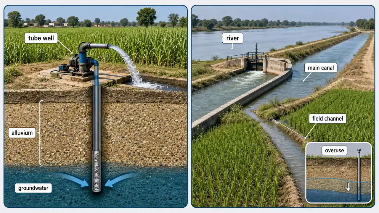
Key Concern: Overexploitation of groundwater in western UP (Upper Doab) has led to declining water tables — classified as "overexploited" or "critical" by CGWB in several districts.
Summary Cheat Sheet
| Sub-region | Key Districts | Signature Feature |
|---|---|---|
| Upper Doab | Meerut, Muzaffarnagar | Sugar Bowl of UP |
| Middle Doab | Kannauj, Farrukhabad | Perfume capital |
| Lower Doab | Prayagraj, Fatehpur | Triveni Sangam |
| Rohilkhand | Bareilly, Moradabad | Brass City; mangoes |
| Awadh | Lucknow, Ayodhya | State capital; cultural heart |
| Eastern Plain | Varanasi, Gorakhpur | Highest rainfall; rice belt |
| Alluvium depth | Very deep; often described up to about 2,000 m near foothills | |
| Top irrigation | Tubewells dominate; the plain is strongly groundwater-dependent |
Lesson Doubts
Ask questions, get expert answers