🏞️ Three Faces of UP — Physical Divisions
A clear explanation of Uttar Pradesh's three main physical divisions: the Gangetic Plain, the southern Vindhyan uplands, and the Terai-Bhabar belt, with their terrain, soils, and exam-focused distinguishing traits.
Introduction
Students often memorize the names of the three physical divisions but do not understand why they matter. The easier way is to imagine Uttar Pradesh from north to south:
- a foothill belt near Nepal
- a vast alluvial plain in the middle
- a more rocky southern upland toward Bundelkhand and Vindhyan districts
Uttar Pradesh covers an area of 2,40,928 sq km and can be divided into three main physiographic divisions based on geological origin, terrain, drainage, and soil characteristics. This lesson is important because later questions on crops, floods, drought, irrigation, and soils all grow out of these physical divisions.
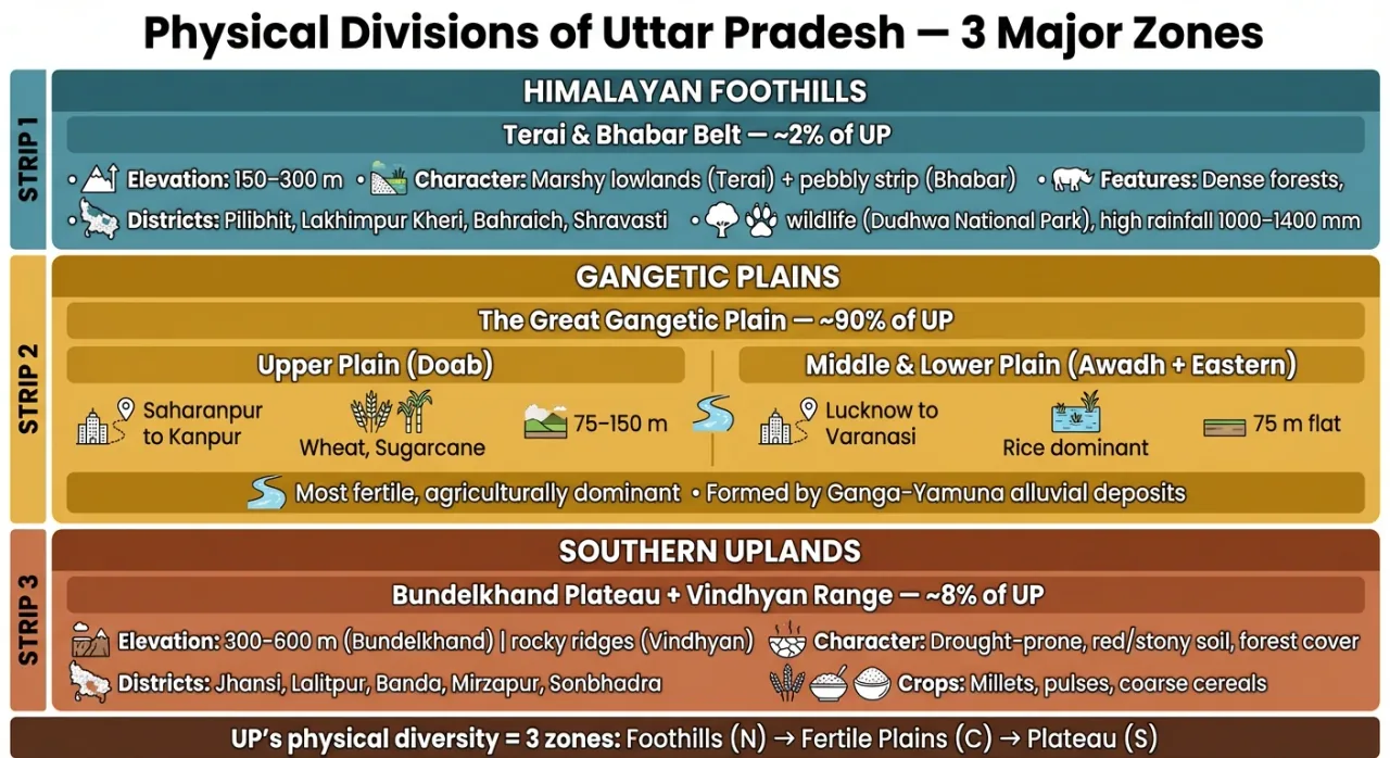
The Three Physiographic Divisions at a Glance
| Division | Hindi Name | Location | Approx. Area Share | Avg. Elevation |
|---|---|---|---|---|
| Gangetic Plain | मैदानी क्षेत्र | Central & Northern UP | ~90% | 75–300 m |
| Vindhyan Range & Plateau | विंध्य पठार | Southern UP | ~8% | 300–600 m |
| Terai-Bhabar Region | तराई-भाबर | Northernmost strip | ~2% | 150–300 m |
These percentages should be treated as approximate teaching values, not as mathematically rigid boundaries. The real importance is the contrast in landform:
- the plain dominates UP
- the southern plateau/upland is much smaller but physically very different
- the Terai-Bhabar belt is narrow yet highly distinctive
1. Gangetic Plain (मैदानी क्षेत्र)
The Gangetic Plain is the largest and most important physiographic division, formed by alluvial deposits of the Ganga and its tributaries over millions of years.
This is the physical base of "mainstream UP" in everyday geography. When students hear about dense population, fertile alluvium, canal irrigation, wheat-rice-sugarcane farming, and floodplains, they are usually hearing about the Gangetic Plain.
Key Characteristics
- Extremely flat terrain with gentle slope from northwest to southeast
- Composed of alluvial soil (both Bangar and Khadar)
- Groundwater table is relatively high — supports extensive irrigation
- Most densely populated and agriculturally productive region
Sub-regions of the Gangetic Plain
| Sub-region | Location / Districts | Key Feature |
|---|---|---|
| Upper Doab (ऊपरी दोआब) | Saharanpur to Aligarh (between Ganga-Yamuna) | Sugarcane, wheat belt; highest canal density |
| Middle Doab (मध्य दोआब) | Aligarh to Kanpur | Transitional zone; mixed cropping |
| Lower Doab (निचला दोआब) | Kanpur to Prayagraj | Confluence region; older alluvium dominant |
| Rohilkhand Plain (रोहिलखंड) | Bareilly, Moradabad, Rampur, Shahjahanpur | Well-watered; rice and sugarcane |
| Awadh Plain (अवध मैदान) | Lucknow, Ayodhya, Sultanpur, Barabanki | Central heartland; diversified agriculture |
| Eastern Plain (पूर्वी मैदान) | Varanasi, Gorakhpur, Azamgarh, Jaunpur | Highest rainfall zone; rice dominance |
The term "Doab" (दोआब) literally means "land between two rivers" — specifically between Ganga and Yamuna.
2. Vindhyan Range & Plateau (विंध्य पठार)
This division covers the southern fringe of UP and is very different from the plain. Instead of fresh river-borne alluvium, you find older hard rocks, broken surfaces, less dependable water availability, and a stronger drought tendency.
Key Characteristics
- Part of the peninsular Indian shield — Precambrian rocks
- Elevation ranges from 300 m to 600 m above sea level
- Terrain is rocky and rugged with ravines along river valleys
- Soil is less fertile — predominantly red, yellow, and mixed soils
- Water scarcity is a persistent problem
Areas Covered
| Region | Districts | Notable Feature |
|---|---|---|
| Bundelkhand | Jhansi, Lalitpur, Jalaun, Hamirpur, Mahoba, Banda, Chitrakoot | Drought-prone; granite/gneiss rocks |
| Vindhyan-Mirzapur | Mirzapur, Sonbhadra | Mineral-rich; sandstone formations |
Agriculture Challenges
- Erratic rainfall and frequent droughts
- Thin soil cover over hard rock — poor water retention
- Ravine formation along Chambal and Yamuna reduces cultivable area
- Government initiatives like Bundelkhand Package aim to address water scarcity
This is why the southern upland belt is often linked in exams with:
- drought
- water scarcity
- ravines
- minerals
- Bundelkhand
3. Terai-Bhabar Region (तराई-भाबर)
This northernmost strip runs along the Nepal border at the base of the Shivalik Hills.
Students often confuse Bhabar and Terai because they are adjacent. The easiest way to remember them is through water behavior:
- in Bhabar, streams sink
- in Terai, that water reappears and creates wet, marshy conditions
Bhabar Zone (भाबर)
- Narrow belt, 8–16 km wide
- Composed of pebbles, gravel, and boulders deposited by Himalayan streams
- Highly porous soil — streams disappear underground
- Unsuitable for agriculture without irrigation
- Very sparse population
Terai Zone (तराई)
- Located south of Bhabar, 15–30 km wide
- Streams that disappeared in Bhabar re-emerge as springs and marshy areas
- Originally dense tropical forests and swamps
- Now significantly cleared for agriculture — rice and sugarcane dominate
- Rich biodiversity; home to Dudhwa National Park
| Feature | Bhabar | Terai |
|---|---|---|
| Width | 8–16 km | 15–30 km |
| Soil | Pebbles, boulders | Clayey, marshy |
| Water | Streams disappear | Streams re-emerge |
| Vegetation | Dry, sparse | Dense, marshy forests |
| Agriculture | Poor | Fertile after reclamation |
Comparative Summary
| Parameter | Gangetic Plain | Vindhyan Plateau | Terai-Bhabar |
|---|---|---|---|
| Origin | Alluvial deposition | Peninsular shield | Sub-Himalayan deposition |
| Terrain | Flat | Rocky, undulating | Marshy to pebbly |
| Soil | Alluvial (fertile) | Red, rocky (less fertile) | Clayey / pebbly |
| Rainfall | 80–170 cm | 75–100 cm | 120–180 cm |
| Major Crops | Wheat, rice, sugarcane | Pulses, coarse grains | Rice, sugarcane |
| Key Challenge | Flood in eastern areas | Drought, ravines | Marshy terrain, wildlife conflict |
Summary Cheat Sheet
| Term | Quick Recall |
|---|---|
| Largest division | Gangetic Plain (~90% area) |
| Doab meaning | Land between two rivers |
| Upper Doab | Saharanpur to Aligarh |
| Vindhyan elevation | 300–600 m |
| Bundelkhand problem | Drought + ravines |
| Bhabar width | 8–16 km |
| Bhabar feature | Streams disappear underground |
| Terai feature | Marshy; streams re-emerge |
| Terai wildlife | Dudhwa National Park |
| Oldest rocks in UP | Vindhyan Plateau (Precambrian) |
Lesson Doubts
Ask questions, get expert answers