🚰 Canal Systems & Irrigation in UP
Canal systems, irrigation sources, Upper Ganga Canal, Sharda Canal, groundwater crisis, micro-irrigation — comprehensive irrigation guide for Uttar Pradesh GK.
Irrigation in Uttar Pradesh
UP is India's largest agricultural state by production, and irrigation is the backbone of this output. Understanding irrigation sources, canal systems, and challenges is critical for the AGTA exam.
The easiest way to understand irrigation in UP is to keep three layers in mind:
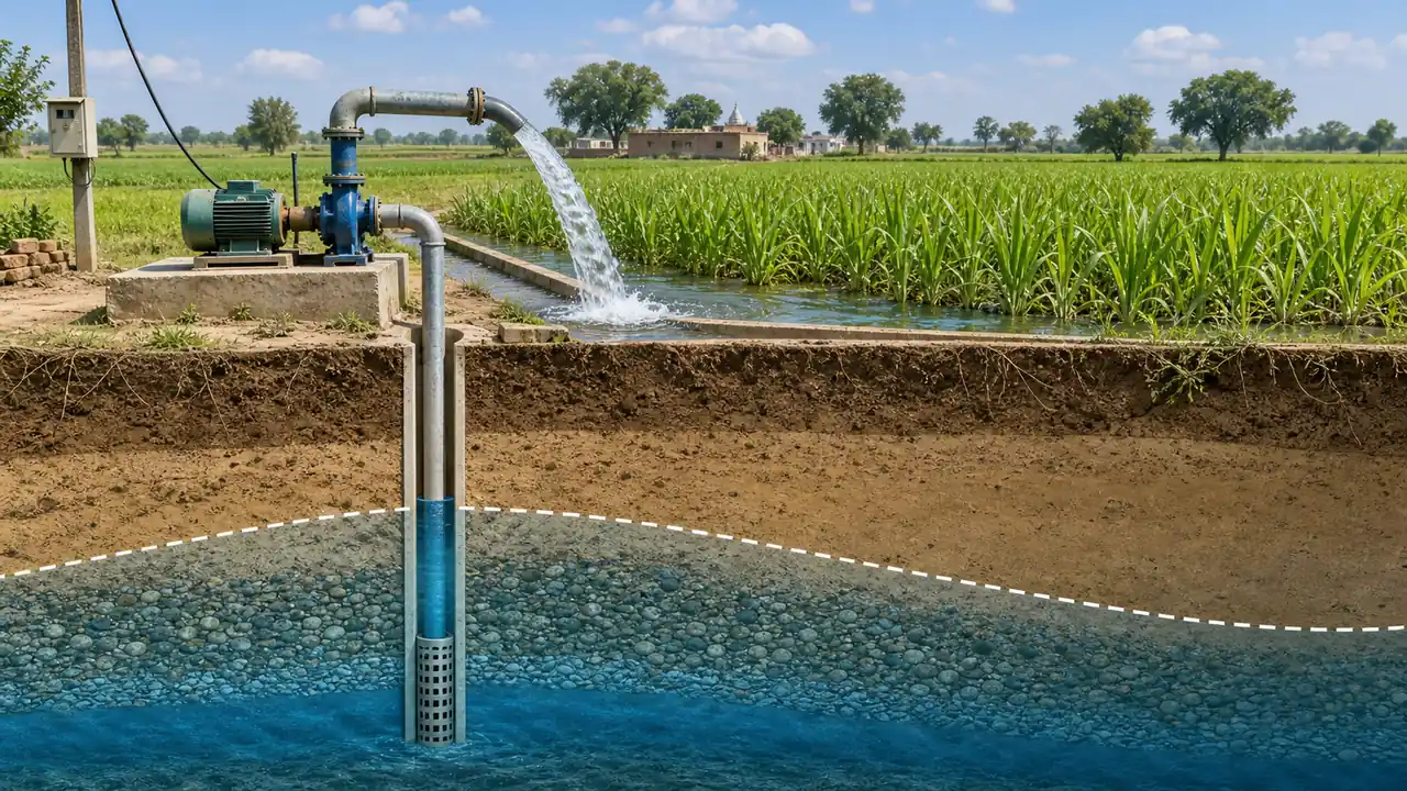
- groundwater irrigation through tube wells, which now dominates
- major canal systems, especially in western UP and the Terai belt
- regional water stress, especially in Bundelkhand and groundwater-stressed western districts
Irrigation Sources — Overview
| Source | Share of Net Irrigated Area | Trend |
|---|---|---|
| Tube wells (groundwater) | ~70% | Increasing — causing depletion |
| Canals | ~20% | Declining share |
| Other sources (tanks, wells, ponds) | ~10% | Minor but locally important |
Key Exam Fact: Tube wells are the single largest source of irrigation in UP, making the state heavily dependent on groundwater.
Major Canal Systems of UP
1. Upper Ganga Canal
| Parameter | Detail |
|---|---|
| Built by | Sir Proby Cautley (British engineer) |
| Commissioned | 1854 |
| Headworks at | Haridwar (from Ganga at Bhimgoda Barrage) |
| Total length | ~560 km (main canal) + 4,800+ km of distributaries |
| Irrigates | Saharanpur, Muzaffarnagar, Meerut, Bulandshahr, Aligarh |
| Irrigated area | ~7 lakh hectares |
| Significance | One of the largest and oldest canal systems in the world |
| Notable feature | Crosses several rivers via aqueducts (e.g., Solani Aqueduct) |
The Upper Ganga Canal transformed the western UP Doab into one of India's most productive agricultural regions.
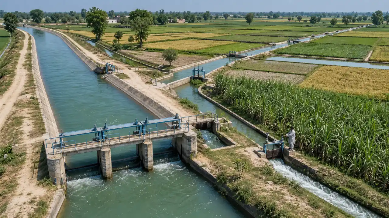
For exams, the Upper Ganga Canal is not just an old British canal. It is the classic example of how canal irrigation changed the agricultural geography of the western Doab.
2. Lower Ganga Canal
| Parameter | Detail |
|---|---|
| Headworks at | Narora Barrage (Bulandshahr district) |
| Commissioned | 1878 |
| Irrigates | Aligarh, Etah, Mainpuri, Farrukhabad, Kanpur |
| Length | ~8,240 km (including distributaries) |
| Significance | Extends irrigation to central Doab region |
3. Sharda Canal System
| Parameter | Detail |
|---|---|
| Headworks at | Banbasa Barrage (on Sharda/Mahakali river, Uttarakhand border) |
| Commissioned | 1928 |
| Irrigates | Pilibhit, Bareilly, Shahjahanpur, Lakhimpur Kheri, Sitapur |
| Region | Terai and Rohilkhand |
| Significance | Major irrigation lifeline for north-central UP |
In practice, students should link the Sharda system with Terai irrigation, not with Bundelkhand or western Yamuna-side agriculture.
4. Agra Canal
| Parameter | Detail |
|---|---|
| Headworks at | Okhla Barrage (Delhi, on Yamuna) |
| Irrigates | Mathura, Agra, western UP |
| Length | ~160 km |
| Built | 1874 |
| Key issue | Severely reduced water flow due to Yamuna pollution and overuse upstream |
5. Eastern Yamuna Canal
| Parameter | Detail |
|---|---|
| Headworks at | Historically Tajewala; now associated with the Hathnikund/Tajewala control point on the Yamuna in Haryana |
| Irrigates | Parts of Saharanpur in UP (mainly serves Haryana) |
| Historical note | Originally built by Firoz Shah Tughlaq (14th century), restored by British |
Comparison of Major Canals
| Canal | Source River | Headworks | Year | Primary Region |
|---|---|---|---|---|
| Upper Ganga | Ganga | Haridwar | 1854 | Western UP (Doab) |
| Lower Ganga | Ganga | Narora | 1878 | Central Doab |
| Sharda | Sharda | Banbasa | 1928 | Terai, Rohilkhand |
| Agra | Yamuna | Okhla (Delhi) | 1874 | Mathura, Agra |
| Eastern Yamuna | Yamuna | Hathnikund/Tajewala zone | Historic origin | Saharanpur side |
Irrigation Statistics
| Parameter | Value |
|---|---|
| Net sown area | ~166 lakh hectares |
| Net irrigated area | ~130 lakh hectares (~78% of net sown area) |
| Gross irrigated area | ~196 lakh hectares |
| Irrigation intensity | ~150% |
| Rank in India | 1st in total irrigated area |
UP is usually ranked among the top states in total and net irrigated area, which explains its dominance in crop production.
Groundwater Crisis
| Parameter | Detail |
|---|---|
| Problem | Over-extraction of groundwater through tube wells |
| Most affected | Western UP (Meerut, Muzaffarnagar, Aligarh, Agra, Mathura) |
| Water table decline | 1-3 metres per year in critical blocks |
| Over-exploited blocks | ~30% of blocks in western UP classified as over-exploited or critical |
| Cause | Paddy-wheat cycle, free/subsidised electricity for pump sets |
| Fluoride issue | Unnao, Rae Bareli, Agra — deep borewells draw fluoride-rich water |
The deeper lesson here is that irrigation success has created a second problem: where tube wells become the main source, farmers gain reliability in the short term but groundwater stress rises in the long term.
Micro-Irrigation Push
The government promotes micro-irrigation to combat water waste:
| Method | Detail |
|---|---|
| Drip irrigation | Water delivered directly to root zone through pipes — 90% efficiency |
| Sprinkler irrigation | Overhead spray — 70-80% efficiency |
| Flood irrigation (traditional) | Only 30-40% efficiency — still dominant in UP |
| Government scheme | Pradhan Mantri Krishi Sinchayee Yojana (PMKSY) — "Per Drop More Crop" |
| Target | Increase water-use efficiency and expand micro-irrigation coverage |
| UP subsidy | 80-90% subsidy on drip/sprinkler for small and marginal farmers |
This topic is more important conceptually than numerically: micro-irrigation matters because it reduces water loss, especially in regions where canal water is limited and groundwater is falling.
Bundelkhand Irrigation — Special Focus
Bundelkhand (Jhansi, Lalitpur, Hamirpur, Mahoba, Banda, Chitrakoot, Jalaun) is UP's most drought-prone region.
| Initiative | Detail |
|---|---|
| Ken-Betwa Link | Will irrigate 4.27 lakh ha in UP Bundelkhand |
| Matatila Canal | From Matatila Dam on Betwa |
| Rajghat Canal | From Rajghat Dam on Betwa |
| Bundelkhand Package | ₹7,266 crore central package for water + infrastructure |
| Rainwater harvesting | Check dams, farm ponds promoted through MGNREGA |
Bundelkhand must be remembered separately from canal-rich western UP. Its irrigation problem is not just lack of canals, but low rainfall reliability, rocky terrain, storage limits, and recurrent drought.
Summary Cheat Sheet
| Fact | Answer |
|---|---|
| Largest irrigation source in UP | Tube wells (~70%) |
| Upper Ganga Canal built by | Sir Proby Cautley (1854) |
| Upper Ganga Canal from | Haridwar |
| Lower Ganga Canal from | Narora Barrage |
| Sharda Canal from | Banbasa Barrage |
| Agra Canal from | Okhla Barrage (Yamuna) |
| Eastern Yamuna Canal control point | Hathnikund/Tajewala zone |
| Net irrigated area rank | Among the top in India |
| Most groundwater-stressed | Western UP |
| Micro-irrigation scheme | PMKSY — Per Drop More Crop |
| Drip irrigation efficiency | 90% |
Lesson Doubts
Ask questions, get expert answers