☁️ Clouds & Cloud Seeding: From Formation to Artificial Rain
Cloud classification into 4 families and 10 types, cloud naming conventions, cloud cover categories, and artificial cloud seeding methods for cold and warm clouds — with agricultural applications
Why Farmers Watch the Clouds
In the previous lesson, we covered humidity, wind, and evapotranspiration — how moisture moves through the atmosphere and affects crop water balance. Now we look at what happens when that moisture condenses: clouds form, and from certain cloud types, precipitation falls.
An experienced farmer in Maharashtra can look at the sky and predict whether rain will come in the next few hours. Dark, towering cumulonimbus clouds warn of hailstorms that can destroy a standing grape vineyard in minutes. Thin, wispy cirrus clouds mean no rain today. Understanding cloud types helps farmers plan irrigation, harvesting, and crop protection — and cloud seeding offers hope during droughts.
This lesson covers:
- Cloud formation — what clouds are and how droplets grow into rain
- Cloud cover categories — clear to overcast, measured in okta
- Cloud classification — the WMO system of 10 types in 4 families
- Cloud naming convention — the five Latin root words
- All 10 cloud types — from high cirrus to dangerous cumulonimbus
- Cloud seeding — cold cloud and warm cloud techniques for artificial rain
All topics are high-yield for IBPS AFO, NABARD Grade A, and FCI exams.
What is a Cloud?
A cloud is a visible aggregate of tiny water droplets and/or ice crystals suspended in the atmosphere. Clouds form when air rises, cools, and water vapour condenses around tiny particles (condensation nuclei).
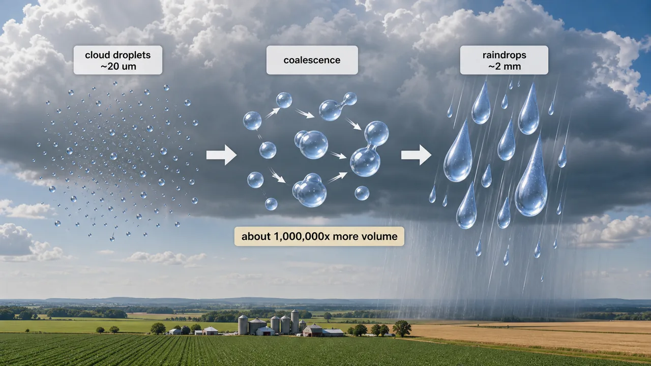
Cloud vs Rain Droplet Size
| Droplet Type | Diameter | Note |
|---|---|---|
| Cloud droplet | ~20 µm | Tiny — stays suspended in air |
| Rain droplet | ~2 mm | Heavy enough to fall |
| Volume ratio (rain : cloud) | ~1,000,000 : 1 | A single raindrop = ~1 million cloud droplets |
NOTE
A raindrop is roughly 100× wider than a cloud droplet, but because volume scales with the cube of diameter, its volume is about one million times larger. This massive growth happens via the coalescence process.
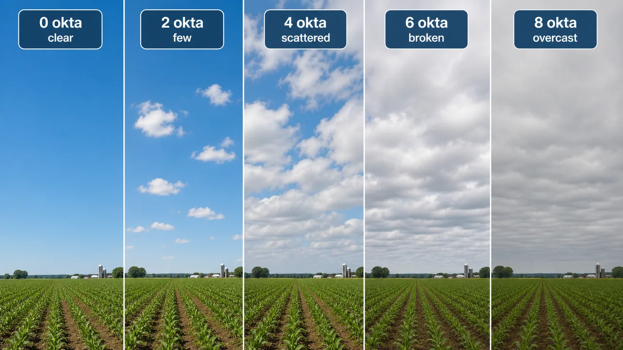
Cloud Cover Categories
Cloud cover describes the fraction of sky obscured by clouds at a given time:
| Category | Sky Coverage | Agricultural Implication |
|---|---|---|
| Clear | Less than 10% | Maximum solar radiation for photosynthesis; high evapotranspiration |
| Scattered | 10% to 60% | Moderate light; comfortable conditions for field work |
| Broken | 60% to 90% | Reduced light; possible rain; harvest operations risky |
| Overcast | More than 90% | Low light; high humidity; pest and disease risk increases |
| Obscured | Cannot determine (fog, dust, heavy rain) | Field operations impossible; frost risk under fog |
TIP
Mnemonic — "C-S-B-O-O": Clear → Scattered → Broken → Overcast → Obscured. Coverage increases in this order. Isoneph lines connect points of equal cloudiness.
Octa — The Unit of Cloud Cover
Sky conditions are officially reported in Octa — the sky is divided into 8 equal parts:
| Okta Value | Meaning |
|---|---|
| 0 okta | Clear sky — no clouds |
| 1–2 okta | Few clouds |
| 3–4 okta | Scattered |
| 5–7 okta | Broken |
| 8 okta | Complete cloud cover (overcast) |
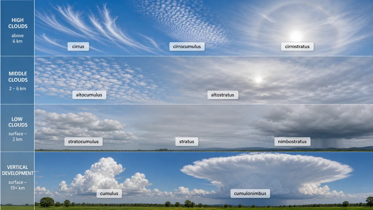
Cloud Classification System
- The modern system was introduced by Luke Howard in 1803.
- Adopted by the World Meteorological Organization (WMO) and published in the International Cloud Atlas (1956).
- WMO was founded from the International Meteorological Organization (IMO, established 1873); ratified 23 March 1950. Headquartered in Geneva, Switzerland.
- World Meteorological Day is observed on 23rd March every year.
- WMO classifies clouds by height and appearance into 10 types grouped into 4 families.
Cloud Naming Convention
Cloud names are built from five Latin root words:
| Root | Meaning | Memory Aid |
|---|---|---|
| Cirro | Curl of hair | High, wispy clouds |
| Strato | Layer | Flat, sheet-like clouds |
| Cumulo | Heap | Puffy, piled-up clouds |
| Alto | Mid-level | Middle-altitude clouds |
| Nimbo | Rain | Precipitation-bearing clouds |
IMPORTANT
Any cloud name containing "nimbo" or "nimbus" is associated with precipitation (rain/snow). This is frequently tested: Nimbostratus = steady rain; Cumulonimbus = violent storms.
Family A — High Clouds (5–13 km)

High clouds form in the upper troposphere where temperatures are well below freezing. All three types are composed entirely of ice crystals.
1. Cirrus (Ci) — The Highest Cloud
| Property | Detail |
|---|---|
| Composition | Ice crystals |
| Appearance | Wispy, feathery, delicate, white fibrous, silky |
| Precipitation | None |
| Special feature | Sun passes through without shadow |
Farm implication: Cirrus clouds indicate fair weather continuing — good day for harvesting or threshing.
2. Cirrocumulus (Cc)
| Property | Detail |
|---|---|
| Composition | Ice crystals |
| Appearance | Rippled sand or waves; white globular masses |
| Precipitation | None |
| Special feature | Produces mackerel sky pattern; also called fleecy clouds, cloud banks, white flakes |
3. Cirrostratus (Cs)
| Property | Detail |
|---|---|
| Composition | Ice crystals |
| Appearance | Whitish veil; milky white covering entire sky |
| Precipitation | None |
| Special feature | Produces a "Halo" — ring of light around sun or moon |
Farm implication: A halo around the moon often indicates that rain may come within 24–48 hours — traditional farmers use this as an early warning.
NOTE
All three high clouds (Ci, Cc, Cs) are made of ice crystals only — temperatures at 5–13 km are far below freezing. None produce precipitation.
Family B — Middle Clouds (2–7 km)
Middle clouds contain a mix of ice and water. They move slower than low clouds.
1. Altocumulus (Ac)
| Property | Detail |
|---|---|
| Composition | Ice and water |
| Appearance | Greyish or bluish globular masses |
| Precipitation | None |
| Special feature | Called sheep back clouds or flock clouds (wool-packed) |
2. Altostratus (As)
| Property | Detail |
|---|---|
| Composition | Water and ice (present separately) |
| Appearance | Fibrous veil or sheet; grey or bluish |
| Precipitation | Rain at middle and high altitudes |
| Special feature | Produces coronas; casts shadow |
Farm implication: Altostratus clouds thickening and lowering usually mean steady rain is approaching — a signal to cover harvested grain.
Family C — Low Clouds (0–2 km)
Low clouds form near the ground and are primarily composed of water droplets.
1. Stratocumulus (Sc)
| Property | Detail |
|---|---|
| Composition | Water |
| Appearance | Soft and grey; large globular masses; long parallel rolls |
| Precipitation | Light |
| Special feature | Spreads more horizontally than vertically; moves faster than cumulus |
2. Stratus (St)
| Property | Detail |
|---|---|
| Composition | Water |
| Appearance | Grayish white sheet covering entire sky near ground |
| Precipitation | Occasional drizzle only |
| Special feature | Mainly seen in winter season; fragmented and thin |
3. Nimbostratus (Ns)
| Property | Detail |
|---|---|
| Composition | Water or ice crystals |
| Appearance | Thick, dark grey, uniform layer; reduces daylight |
| Precipitation | Steady, continuous precipitation |
| Special feature | The primary rain-bearing low cloud |
Farm implication: Nimbostratus clouds mean prolonged, steady rainfall — excellent for soil moisture recharge but dangerous for crops being harvested or dried in the field.
WARNING
Exam confusion alert: Stratus (St) gives only light drizzle. Nimbostratus (Ns) gives steady, continuous rain. The "nimbo" prefix is the key to remembering which one brings real precipitation.
Family D — Clouds with Vertical Development (0–13 km)
These clouds form due to convection and can extend from near the ground to the top of the troposphere.
1. Cumulus (Cu)
| Property | Detail |
|---|---|
| Composition | Water |
| Appearance | White, majestic, flat base; looks like cauliflower, cotton, or wool pack |
| Precipitation | Light showers |
| Special feature | Fair-weather cloud; can develop into Cumulonimbus |
Farm implication: Small cumulus clouds on a summer afternoon indicate unstable air — if they grow tall, expect thundershowers beneficial for kharif crops.
2. Cumulonimbus (Cb) — The Most Dangerous Cloud
| Property | Detail |
|---|---|
| Composition | Ice (upper levels) + Water (lower levels) |
| Appearance | Towering with anvil top; known as thunder head |
| Precipitation | Violent winds, thunderstorms, hail, and lightning |
| Special feature | The only cloud that produces lightning, hail, tornadoes, and violent storms simultaneously |
Farm implication: Cumulonimbus clouds are the farmer's worst enemy during sensitive crop stages. Hail from Cb clouds destroys mango orchards, grape vineyards, and standing wheat. Hailstorms occur before onset and after withdrawal of monsoon.
IMPORTANT
Cumulonimbus (Cb) is the most dangerous cloud. It is the only cloud type that can produce lightning, hail, tornadoes, and violent thunderstorms simultaneously. Height of thunderstorms is related to latitude and season.
Complete Cloud Comparison Table
| Cloud | Abbr. | Family | Height | Composition | Precipitation | Distinguishing Feature |
|---|---|---|---|---|---|---|
| Cirrus | Ci | A (High) | 5–13 km | Ice crystals | None | Highest cloud; wispy, feathery |
| Cirrocumulus | Cc | A (High) | 5–13 km | Ice crystals | None | Mackerel sky; fleecy |
| Cirrostratus | Cs | A (High) | 5–13 km | Ice crystals | None | Produces Halo |
| Altocumulus | Ac | B (Mid) | 2–7 km | Ice + Water | None | Sheep back / flock clouds |
| Altostratus | As | B (Mid) | 2–7 km | Water + Ice | Rain at mid-altitudes | Produces Coronas |
| Stratocumulus | Sc | C (Low) | 0–2 km | Water | Light | Parallel rolls |
| Stratus | St | C (Low) | 0–2 km | Water | Drizzle only | Winter; grey sheet |
| Nimbostratus | Ns | C (Low) | 0–2 km | Water/Ice | Steady rain | Dark grey; reduces daylight |
| Cumulus | Cu | D (Vertical) | 0–13 km | Water | Light showers | Cauliflower shape; flat base |
| Cumulonimbus | Cb | D (Vertical) | 0–13 km | Ice + Water | Violent storms, hail | Thunder head; anvil top |
Quick Cloud Facts — One-liner Exam Recall
| Fact | Cloud |
|---|---|
| Fibrous cloud | Cirrus |
| Low height cloud | Cumulus |
| Drizzle only | Stratus |
| Heavy, steady rain | Nimbostratus |
| Hail and lightning | Cumulonimbus |
| Good rainfall at high latitudes | Altostratus |
| "Nimbus" / "Nimbo" in name | Always = rain-producing cloud |
Cloud Seeding — Artificial Rainmaking
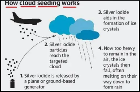
When natural clouds form but do not produce enough rain, humans can intervene. Cloud seeding is the primary technique for artificial rainmaking and has been deployed in drought-affected Indian states.
Cloud seeding is a process of inducing rain from rain-bearing clouds by injecting artificial condensation nuclei through aircraft or ground-based generators. It is a tool used to mitigate drought effects on agriculture.
The method differs for cold clouds and warm clouds:
Seeding of Cold Clouds
Cold clouds (temperature below 0°C) can be seeded by two methods:
| Method | Agent | Temperature | Mechanism | Limitation |
|---|---|---|---|---|
| Dry Ice Seeding | Solid CO₂ | -80°C | Extreme cooling causes ice crystal formation | Short-lived; no persistent effects; heavy, falls rapidly |
| Silver Iodide (AgI) Seeding | Silver iodide smoke | Works below -5°C | Crystal structure mimics ice; acts as ice-forming nuclei | More persistent; can be released from ground generators |
Seeding of Warm Clouds
Warm clouds (temperature above 0°C) require hygroscopic (water-attracting) molecules:
| Agent | Type |
|---|---|
| Common salt (NaCl) | Hygroscopic |
| Magnesium chloride (MgCl₂) | Hygroscopic |
| Calcium chloride (CaCl₂) | Hygroscopic |
| Urea | Hygroscopic |
| Ammonium nitrate | Hygroscopic |
The coalescence process is responsible for raindrop growth in warm clouds — small droplets collide and merge into drops heavy enough to fall as rain.
Cold vs Warm Cloud Seeding — Comparison
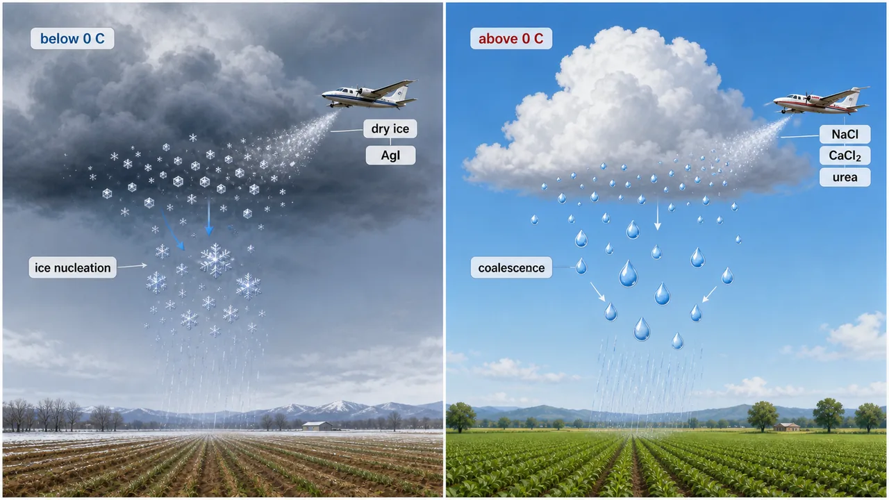
| Feature | Cold Cloud Seeding | Warm Cloud Seeding |
|---|---|---|
| Cloud temperature | Below 0°C | Above 0°C |
| Agents | Dry ice (solid CO₂), Silver iodide (AgI) | NaCl, MgCl₂, CaCl₂, Urea, Ammonium nitrate |
| Mechanism | Ice nucleation | Hygroscopic coalescence |
| Delivery | Aircraft (dry ice), ground generators (AgI) | Aircraft or ground-based sprayers |
IMPORTANT
Exam favourite: Cold cloud seeding = Dry ice or Silver iodide (ice nucleation). Warm cloud seeding = NaCl, MgCl₂, CaCl₂, Urea, Ammonium nitrate (hygroscopic coalescence). This distinction is frequently tested in IBPS AFO, NABARD Grade A, and FCI exams.
Agricultural significance: Cloud seeding has been used in India during drought years to supplement monsoon rainfall. States like Maharashtra, Karnataka, and Tamil Nadu have conducted cloud seeding operations to save kharif crops from drought stress.
Summary Table
| Topic | Key Fact | Exam Value |
|---|---|---|
| Cloud definition | Visible aggregate of water droplets/ice crystals | Definition question |
| WMO | Founded from IMO (1873); ratified 23 March 1950; HQ Geneva | Organisation question |
| World Meteorological Day | 23rd March | Date question |
| Cloud classification by | Luke Howard (1803); adopted by WMO | Name and year |
| Number of cloud types | 10 types in 4 families | Counting question |
| Nimbo/Nimbus | Indicates precipitation | Naming convention |
| High clouds (Family A) | Cirrus, Cirrocumulus, Cirrostratus — all ice crystals | Composition question |
| Cirrus | Highest cloud; wispy; no precipitation | Identification |
| Cirrostratus | Produces Halo around sun/moon | Special feature |
| Altocumulus | Sheep back / flock clouds | Name question |
| Altostratus | Produces coronas; rain at mid-altitudes | Special feature |
| Nimbostratus | Steady continuous precipitation; dark grey | Rain-bearing cloud |
| Cumulonimbus | Most dangerous; thunder head; hail, lightning, tornado | Most tested cloud |
| Cloud droplet size | ~20 µm | Size question |
| Rain droplet size | ~2 mm; volume ratio rain:cloud = ~1,000,000:1 | Size/ratio question |
| Cloud cover — Octa | Sky divided into 8 parts; 0 = clear, 8 = overcast | Unit question |
| Cloud cover — Overcast | > 90% sky coverage | Percentage question |
| Dry ice | Solid CO₂; -80°C; cold cloud seeding | Agent identification |
| Silver iodide (AgI) | Works below -5°C; ice-forming nuclei | Agent identification |
| Warm cloud agents | NaCl, MgCl₂, CaCl₂, Urea, Ammonium nitrate | Agent listing |
| Coalescence process | Raindrop growth in warm clouds | Process name |
| Hailstorms timing | Before onset and after withdrawal of monsoon | Timing question |
Summary Cheat Sheet
| Concept / Topic | Key Details |
|---|---|
| Cloud definition | Visible aggregate of water droplets/ice crystals in atmosphere |
| WMO | Founded from IMO (1873); ratified 23 March 1950; HQ Geneva |
| World Meteorological Day | 23rd March |
| Cloud classification by | Luke Howard (1803); adopted by WMO |
| Cloud types | 10 types in 4 families (High, Middle, Low, Vertical) |
| Nimbo/Nimbus | Indicates precipitation-bearing cloud |
| Cirrus | Highest cloud; wispy; ice crystals; no precipitation |
| Cirrostratus | Produces Halo around sun/moon |
| Altocumulus | Sheep back / flock clouds |
| Nimbostratus | Steady continuous precipitation; dark grey |
| Cumulonimbus | Most dangerous — thunder head; hail, lightning, tornado |
| Cloud droplet | ~20 µm; rain droplet ~2 mm; volume ratio ~1,000,000:1 |
| Cloud cover unit | Octa (8 parts); 0 okta = clear; 8 okta = overcast |
| Overcast | > 90% sky coverage |
| Cold cloud seeding agents | Dry ice (solid CO₂) and Silver iodide (AgI) |
| Warm cloud seeding agents | NaCl, MgCl₂, CaCl₂, Urea, Ammonium nitrate (hygroscopic) |
| Cold cloud mechanism | Ice nucleation (below 0°C) |
| Warm cloud mechanism | Hygroscopic coalescence (above 0°C) |
| Coalescence process | Raindrop growth in warm clouds — droplets collide and merge |
| AgI works below | -5°C as ice-forming nuclei |
| Hailstorms timing | Before onset and after withdrawal of monsoon |
| Cloud seeding in India | Maharashtra, Karnataka, Tamil Nadu during drought years |
TIP
Next: Lesson 07 covers drought, climate classification, and agro-climatic zones — drought types, weather forecasting, Koppen and Thornthwaite systems, India's 15 agro-climatic zones, and meteorological instruments.
Lesson Doubts
Ask questions, get expert answers