🗺️ India's Agro-Climatic Landscape
Understand India's agro-climatic zones, NARP regions, agro-ecological regions, and length-of-growing-period logic.
In the previous lesson, we established the foundations of agronomy — what agriculture is, how it evolved, and which external and internal factors affect crop production. One of the most important external factors is climate, and India's climate varies enormously from region to region. This lesson maps that diversity.
India feeds nearly 18% of the world's population on just 2.4% of the world's geographical area. But this impressive output is not uniform — it is shaped by the tremendous diversity of India's climates, soils, and landscapes. To understand what India grows and where, we must first understand how the country is divided into agro-climatic zones.
This lesson covers:
- Why agro-climatic zoning matters and what defines a zone
- Three classification systems — Planning Commission (15 ACZs), ICAR NARP (127 ACZs), NBSS&LUP (20 AERs)
- Detailed profiles of all 15 zones — states, climate, crops, and production links
- LGP-based ecosystem classification — arid to humid
All sections are high-yield for exams, FCI, and exams.
Pro Content Locked
Upgrade to Pro to access this lesson and all other premium content.
₹99 charged monthly · Cancel anytime
- All Agriculture & Banking Courses
- AI Lesson Questions (100/day)
- AI Doubt Solver (50/day)
- Glows & Grows Feedback (30/day)
- AI Section Quiz (20/day)
- 22-Language Translation (100/day)
- Recall Questions (20/day)
- AI Quiz (15/day)
- AI Quiz Paper Analysis (100/day)
- AI Step-by-Step Explanations (100/day)
- Spaced Repetition Recall (FSRS)
- AI Tutor
- Immersive Text Questions
- Audio Lessons — Hindi & English
- Mock Tests & Previous Year Papers
- Summary & Mind Maps
- XP, Levels, Leaderboard & Badges
- Generate New Classrooms
- Voice AI Teacher (AgriDots Live)
- AI Revision Assistant
- Knowledge Gap Analysis
- Interactive Revision (LangGraph)
🔒 Secure via Razorpay · Cancel anytime · No hidden fees
In the previous lesson, we established the foundations of agronomy — what agriculture is, how it evolved, and which external and internal factors affect crop production. One of the most important external factors is climate, and India's climate varies enormously from region to region. This lesson maps that diversity.
India feeds nearly 18% of the world's population on just 2.4% of the world's geographical area. But this impressive output is not uniform — it is shaped by the tremendous diversity of India's climates, soils, and landscapes. To understand what India grows and where, we must first understand how the country is divided into agro-climatic zones.
This lesson covers:
- Why agro-climatic zoning matters and what defines a zone
- Three classification systems — Planning Commission (15 ACZs), ICAR NARP (127 ACZs), NBSS&LUP (20 AERs)
- Detailed profiles of all 15 zones — states, climate, crops, and production links
- LGP-based ecosystem classification — arid to humid
All sections are high-yield for exams, FCI, and exams.
Why Does India Need Agro-Climatic Zoning?
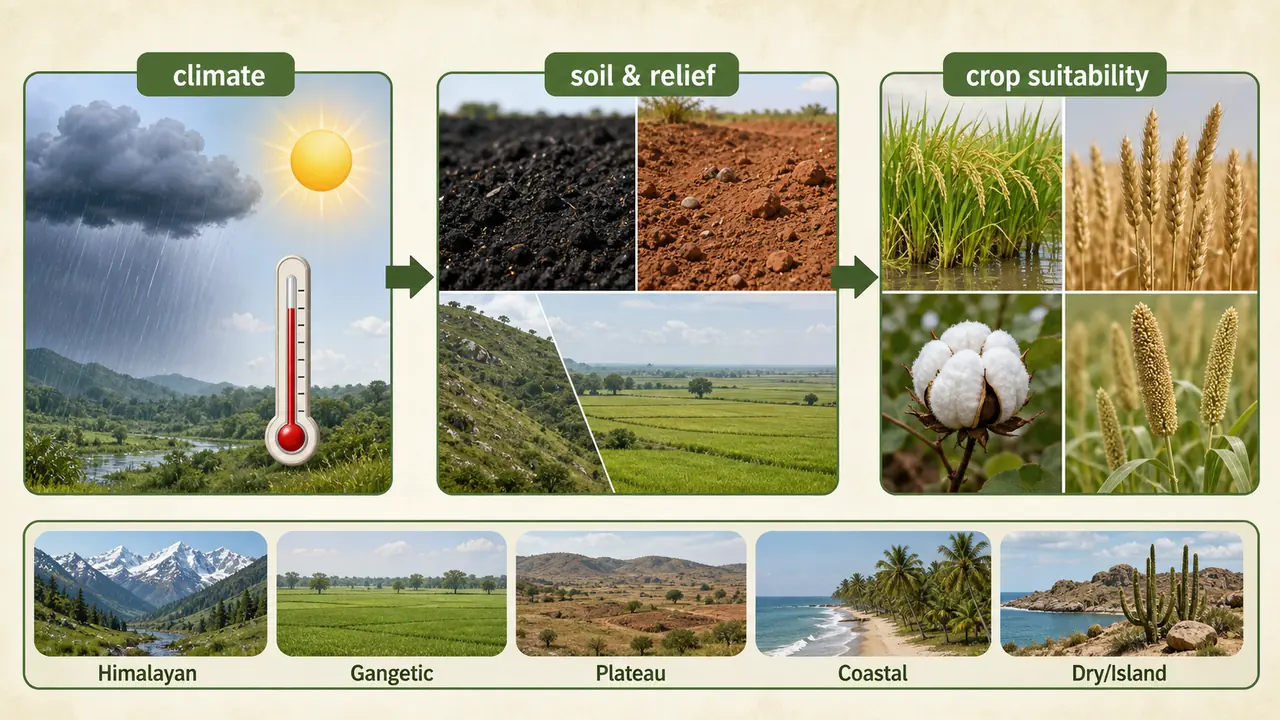
A single wheat variety bred for Punjab will not perform well in the laterite soils of Kerala. India's agriculture spans arid deserts, humid tropics, alpine meadows, and coastal plains. No single technology or practice fits everywhere. Agro-climatic zoning divides the country into regions of similar climate, soil, and growing conditions so that crop choices, varieties, and management practices can be matched to local conditions for maximum productivity.
What is an Agro-Climatic Zone?
An Agro-Climatic Zone (ACZ) is a geographically defined land unit that is uniform in climate and length of growing period (LGP), making it suitable for a specific range of crops and cultivars (FAO, 1983).
Length of Growing Period (LGP) = the number of days when both moisture and temperature are adequate for crop growth. Regions with longer LGP support longer-duration crops; those with shorter LGP need quick-maturing varieties.
Factors Used for Classification
| Factor | Examples |
|---|---|
| Climatic | Rainfall, Temperature |
| Soil | Soil type, pH, depth |
| Physiographic | Topography, drainage |
| Agronomic | Cropping pattern |
| Resources | Irrigation, minerals |
Three Major Classification Systems
India has been classified using three different systems, each progressively finer in resolution. The Planning Commission's 15-zone system is the most commonly examined; the ICAR NARP system gives research-level granularity; and the NBSS&LUP system incorporates soil and vegetation data for the most precise agricultural planning.
IMPORTANT
Key numbers for exams:
- Planning Commission --> 15 ACZs --> 73 sub-zones
- ICAR (NARP) --> 127 ACZs
- NBSS&LUP --> 20 AERs --> 60 sub-zones
| Classification | Authority | Year | Zones | Basis |
|---|---|---|---|---|
| Agro-Climatic Zones | Planning Commission | 1988-89 | 15 (73 sub-zones) | Rainfall, temperature, topography, cropping & farming systems, water resources |
| Agro-Climatic Zones (NARP) | ICAR | 1980 | 127 | Rainfall pattern, cropping pattern, administrative units |
| Agro-Ecological Regions | NBSS&LUP (ICAR) | -- | 20 (60 sub-zones) | Bioclimate + LGP + Soils & physiography (FAO 1978 concept) |
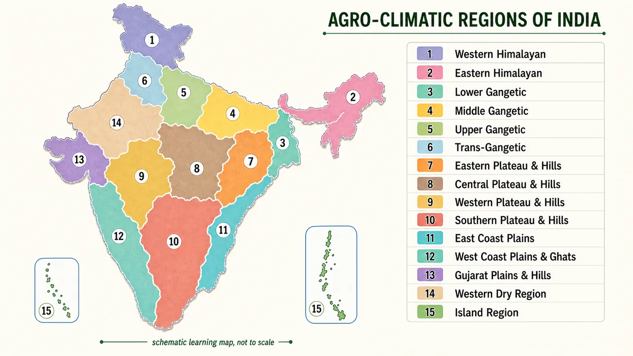
15 Agro-Climatic Zones (Planning Commission)
| Broad Region Block | Included Planning Commission Zones | Dominant Boundary Drivers |
|---|---|---|
| Himalayan belt | Western Himalayan, Eastern Himalayan | Altitude, temperature, heavy rainfall, relief |
| Gangetic plains | Lower Gangetic, Middle Gangetic, Upper Gangetic, Trans-Gangetic | Alluvial plains, monsoon rainfall, irrigation intensity |
| Plateau and hills | Eastern Plateau and Hills, Central Plateau and Hills, Western Plateau and Hills, Southern Plateau and Hills | Plateau relief, soil type, moisture stress, dryland farming pattern |
| Coastal belt | East Coast Plains, West Coast Plains and Ghats | Maritime climate, coastal soils, monsoon influence |
| Dry and island regions | Gujarat Plains and Hills, Western Dry Region, Island Region | Aridity, coastal influence, island ecology |
India's planning zones follow broad climatic patterns, which is why rainfall, relief, and temperature drive zone boundaries.
These 15 zones — from the snow-capped Western Himalayas to the tropical Islands — represent the full spectrum of India's agricultural environments. Each zone's climate, soil, and rainfall determine its crop portfolio. Exams frequently test zone-state-crop associations.
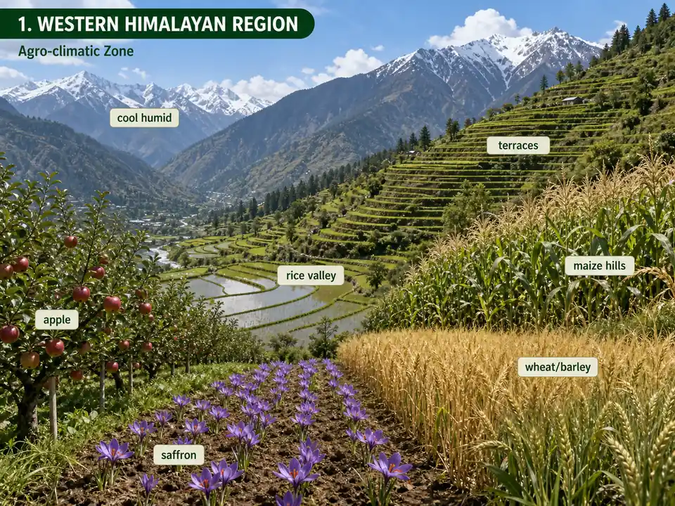
1. Western Himalayan Region
- States: Jammu & Kashmir, Himachal Pradesh, Uttarakhand
- Climate: Cool and humid | Rainfall: 1650-2000 mm
- Soils: Predominantly alluvial
- Crops: Rice (valleys), maize (hills) in kharif; barley, oats, wheat in rabi
- Horticulture: Apple, peach, apricot, pear, cherry, almond, walnut, saffron
- Key fact: Cropping intensity lowest in J&K, highest in Himachal Pradesh
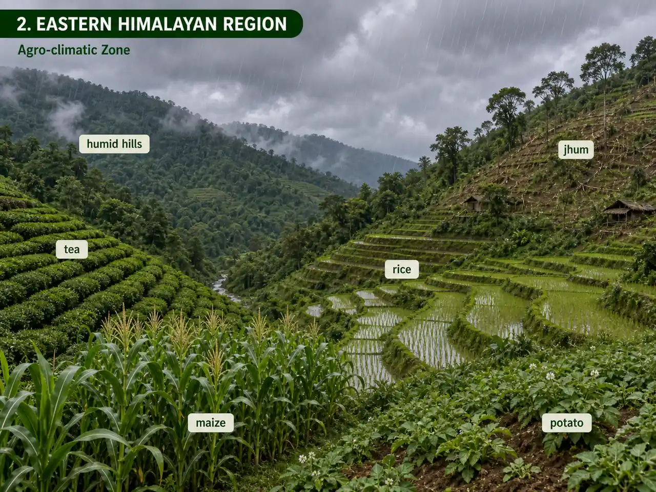
2. Eastern Himalayan Region
- States: Arunachal Pradesh, Assam hills, Sikkim, Meghalaya, Nagaland, Manipur, Mizoram, Tripura, parts of West Bengal (Jalpaiguri, Coochbihar, Darjeeling)
- Climate: Humid and sub-humid | Rainfall: 1840-3528 mm (among highest in the world)
- Crops: Rice, maize, potato, tea
- Special practice: Jhuming (shifting/slash-and-burn cultivation) in hilly areas
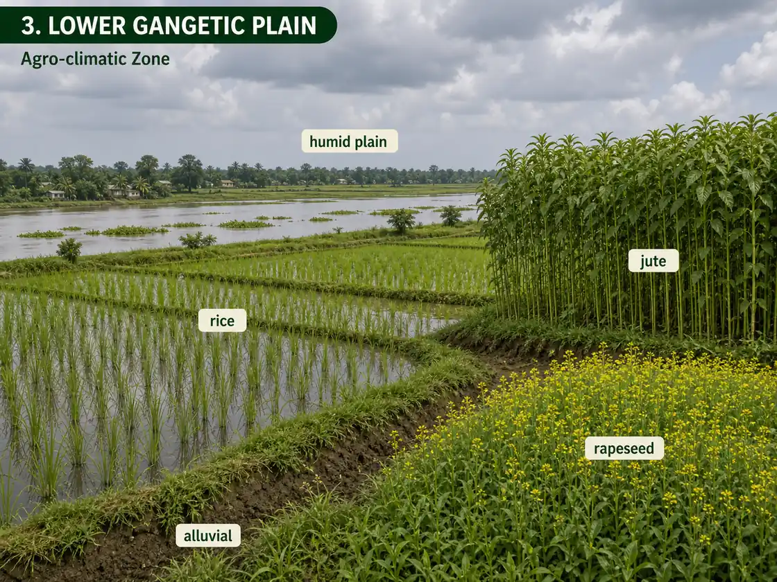
3. Lower Gangetic Plain
- States: West Bengal
- Climate: Moist humid and dry humid | Rainfall: 1302-1607 mm
- Crops: Rice (main), jute, rapeseed, wheat
- Key fact: Rice productivity lower than national average but contributes 12% of total production due to large area
- Production link: Lower Gangetic conditions strongly favor rice and jute. In the 2023-24 DES tables, Telangana (16.87 MT) and Uttar Pradesh (15.99 MT) are ahead of West Bengal (15.69 MT) in rice production, while all-India rice production stands at 137.82 MT.
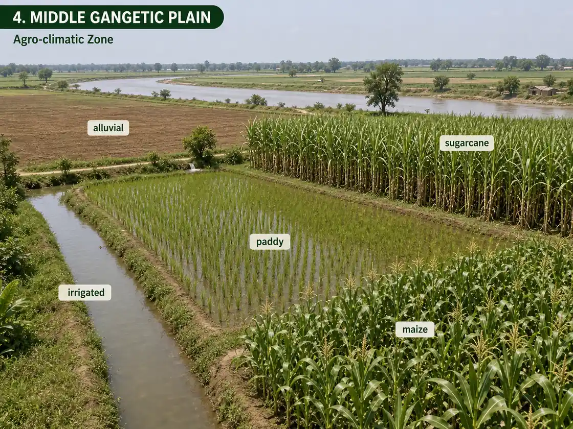
4. Middle Gangetic Plain
- States: Eastern UP, Bihar plains
- Climate: Moist sub-humid to dry humid | Rainfall: 1211-1470 mm
- Soils: Fertile alluvial (Ganga and tributaries)
- Crops: Sugarcane, paddy, maize, wheat
- Key fact: 40% area irrigated; cropping intensity 142%
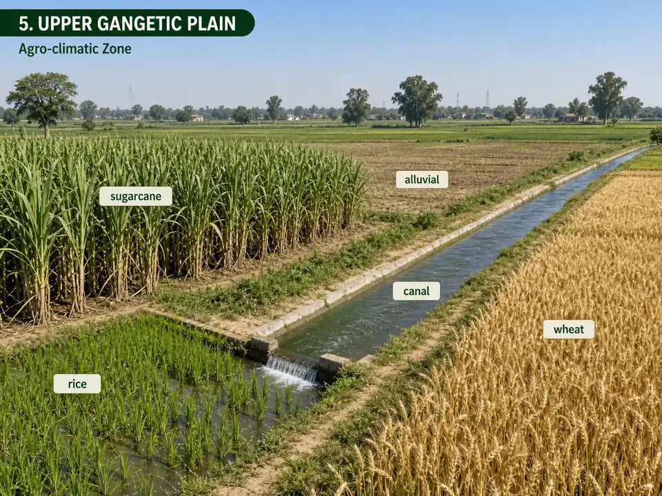
5. Upper Gangetic Plain
- States: Western UP
- Climate: Dry sub-humid to sub-dry | Rainfall: 721-979 mm
- Crops: Rice, wheat, maize, sugarcane
- Key fact: Major sugarcane growing area (exams 2021); irrigation intensity 131%; cropping intensity 145%
- Production link: UP still leads India in sugarcane production, and official 2023-24 all-India sugarcane production is 453.16 MT. Vast alluvial plains with canal + tubewell irrigation support both kharif (rice) and rabi (wheat) cycles.
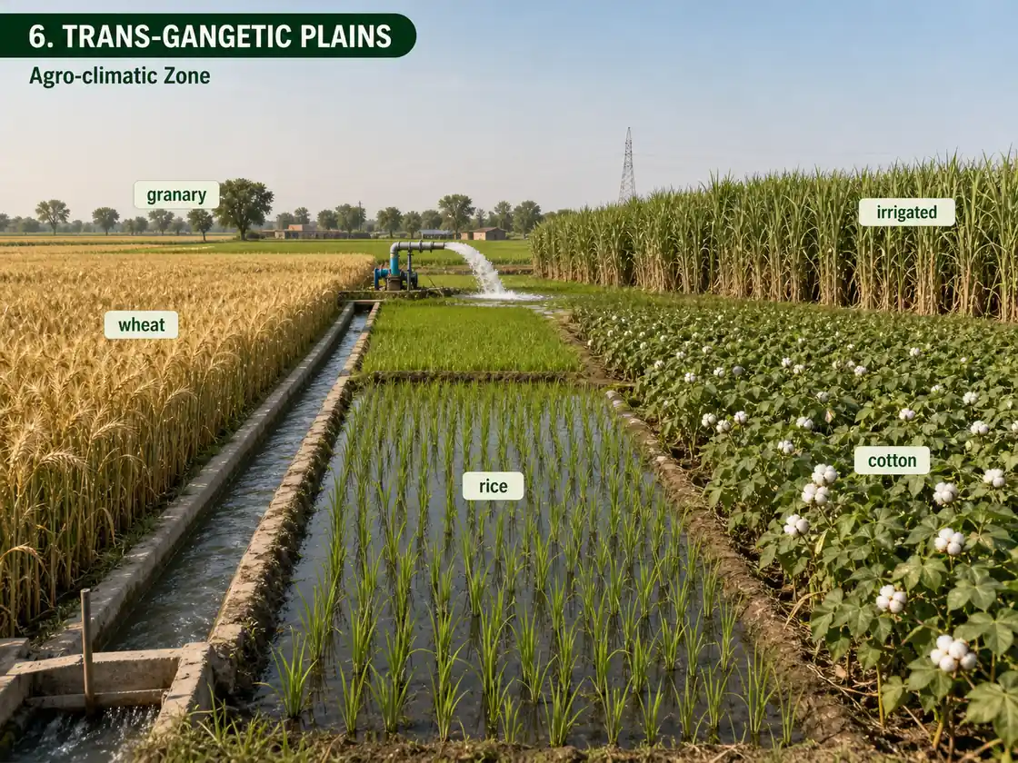
6. Trans-Gangetic Plains
- States: Punjab, Haryana, Chandigarh, Delhi, Ganganagar (Rajasthan)
- Climate: Semi-arid | Rainfall: 65-125 cm
- Crops: Wheat, sugarcane, cotton, rice, gram, maize
- Key fact: Highest cropping intensity in India; called the "Granary of India"
- Production link: Punjab leads in wheat & rice productivity; Haryana in mustard productivity. Why? Near-universal irrigation (98%), Green Revolution HYV adoption, fertile alluvial soils, and cool winters ideal for wheat grain filling. UP (Zones 4-5) leads in total food grain production by sheer area.
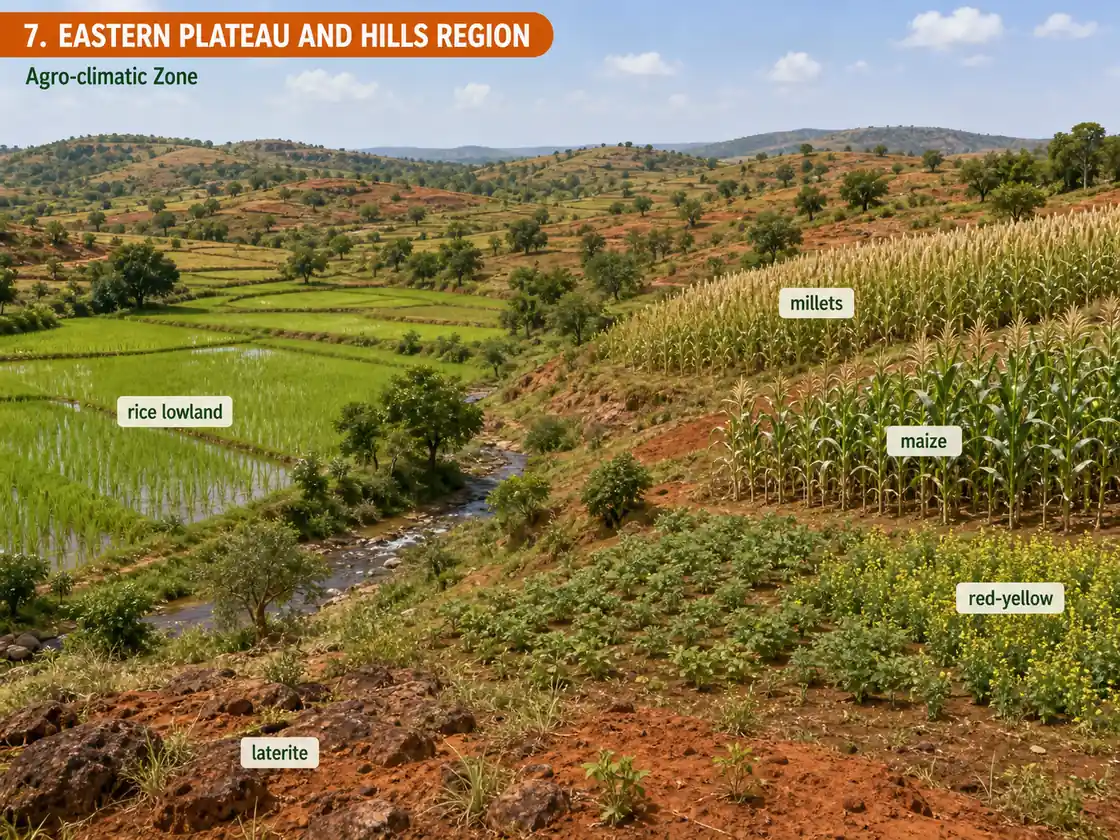
7. Eastern Plateau and Hills
- States: Eastern Madhya Pradesh, Jharkhand, Chhattisgarh, inland Odisha, and uplands of West Bengal
- Climate: Moist sub-humid to dry sub-humid | Rainfall: 1271-1436 mm
- Soils: Red and yellow with laterite patches
- Crops: Rice, millets, maize, oilseeds, ragi, gram, potato
- Constraint: Water deficiency due to plateau structure and non-perennial streams
- Production link: MP spans Zones 7-8-9 and dominates pulses and oilseeds — its mix of black cotton soils (regur) and red soils suits dryland crops like gram, soybean, and mustard
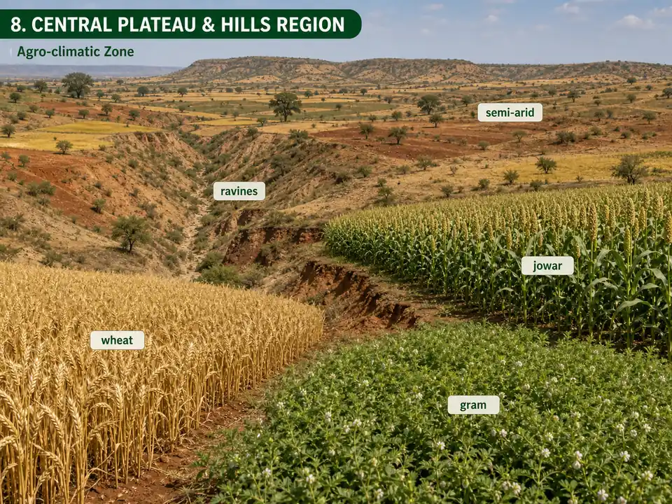
8. Central Plateau and Hills
- States: 46 districts of Madhya Pradesh, Uttar Pradesh, Rajasthan
- Climate: Semi-arid to dry sub-humid | Rainfall: 400-1550 mm
- Soils: Mixed red, yellow, and black
- Crops: Wheat, gram, jowar, bajra, paddy, oilseeds, cotton
- Constraint: Water scarcity; undulating topography with ravines
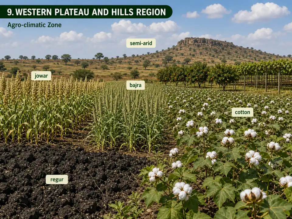
9. Western Plateau and Hills
- States: Major part of Maharashtra, parts of Madhya Pradesh, one district of Rajasthan
- Climate: Semi-arid | Rainfall: 602-1040 mm
- Soils: Regur (black cotton soil) -- high moisture retention Exams
- Crops: Jowar, bajra, cotton, wheat
- Key fact: Provides 50% of India's jowar; best quality orange, grape, and banana
- Production link: Maharashtra leads in sorghum area & production; Gujarat leads in cotton production — extensive black soil (regur) tracts in both states are ideal for deep-rooted, moisture-retaining crops
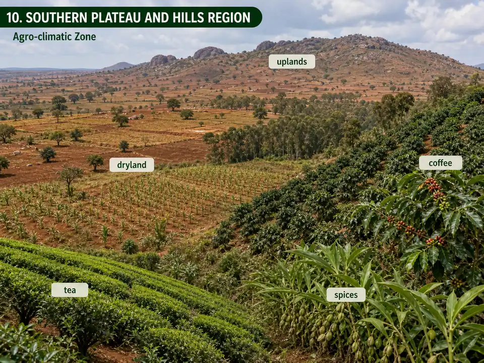
10. Southern Plateau and Hills
- States: Karnataka, Telangana, Rayalaseema (Andhra Pradesh), and Tamil Nadu uplands
- Climate: Dry-zone agriculture | Rainfall: 677-1000 mm
- Crops: Coffee, tea, cardamom, spices
- Key fact: 81% dryland farming; cropping intensity 111%
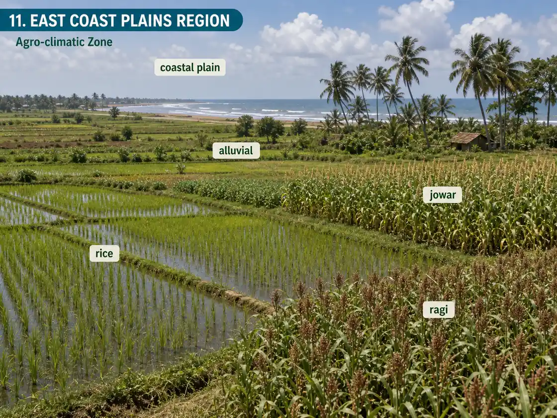
11. East Coast Plains
- States: Odisha, Andhra Pradesh, Tamil Nadu, Puducherry
- Climate: Semi-arid to dry sub-humid | Rainfall: 780-1287 mm
- Soils: Alluvial and coastal sands (alkalinity problem from sea water intrusion)
- Crops: Rice, ragi, jowar, bajra
- Key fact: Contributes 20.3% of rice and 17.5% of groundnut production; 75% rainfed
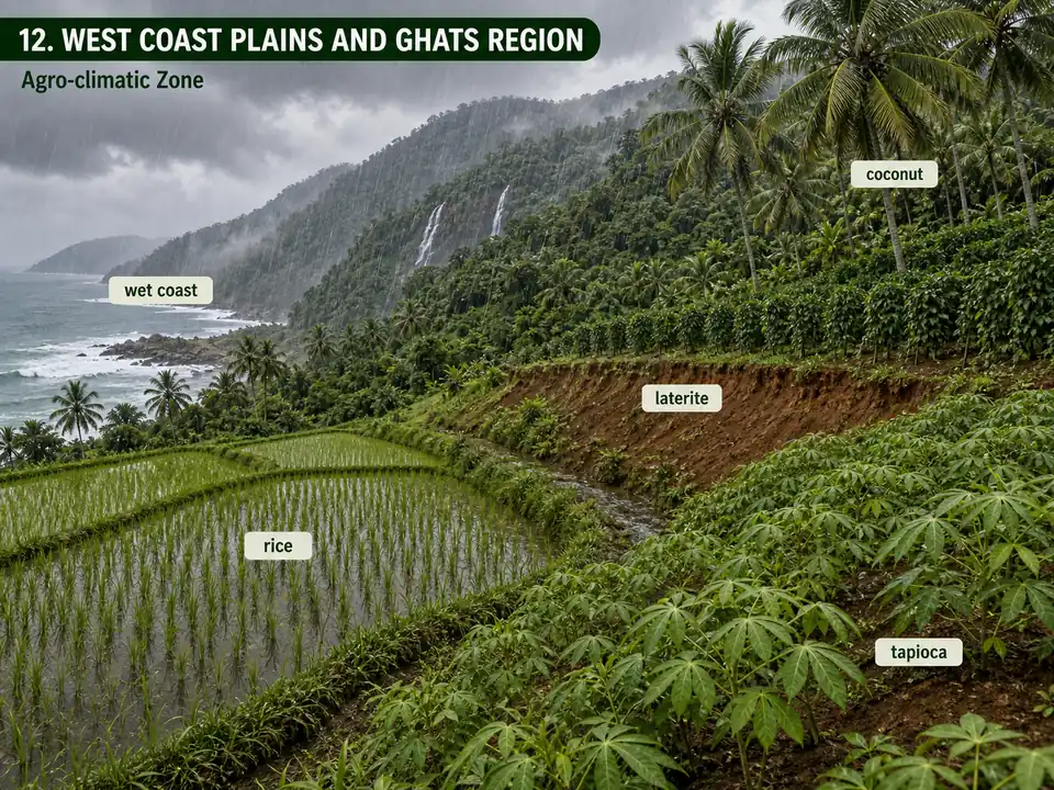
12. West Coast Plains and Ghats
- States: Tamil Nadu, Kerala, Goa, Karnataka, Maharashtra
- Climate: Dry sub-humid to humid | Rainfall: 2226-3640 mm (one of the wettest regions)
- Soils: Laterite and coastal alluvial
- Crops: Rice, ragi, groundnut, tapioca; spices and plantation crops on Ghat slopes
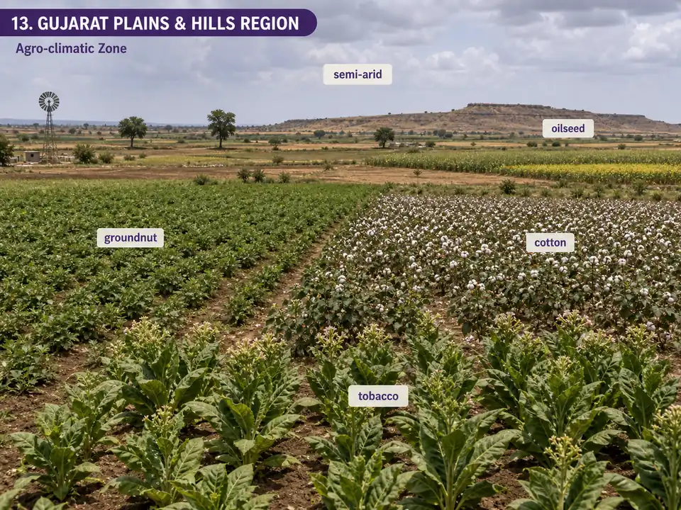
13. Gujarat Plains and Hills
- States: 19 districts of Gujarat
- Climate: Arid and semi-arid | Rainfall: 340-1793 mm (wide range reflects diverse geography)
- Soils: Regur (plateau), alluvium (coast), red-yellow (Jamnagar)
- Crops: Maize, wheat, groundnut, tobacco, cotton, jowar, bajra
- Key fact: Known as the oilseed region; 60% drought-prone; 78% rainfed
- Production link: Gujarat leads in groundnut and cotton production — regur soils on the plateau retain moisture for cotton; sandy-loam coastal soils suit groundnut. Also leads in tobacco area and production
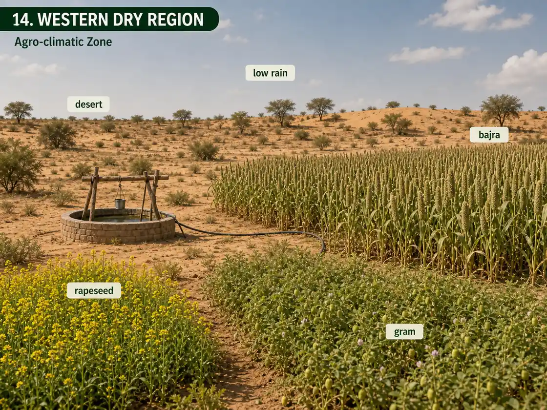
14. Western Dry Region
- States: 9 districts of Rajasthan
- Climate: Desert | Rainfall: Erratic, average 95 mm (one of the driest regions in India)
- Crops: Bajra, gram, wheat, rapeseed
- Key fact: 1.2% forest; 6.3% irrigated; cropping intensity 105% (nearly single-crop)
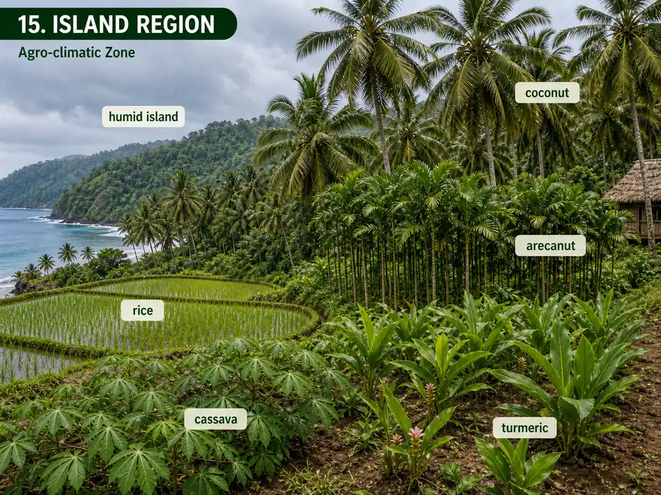
15. Island Region
- States: Andaman & Nicobar, Lakshadweep
- Climate: Humid (tropical maritime) | Rainfall: ~3000 mm over 8-9 months
- Crops: Rice, maize, millets, pulses, arecanut, turmeric, cassava
- Key fact: Nearly half the cropped area is under coconut
Zone Summary Table
| S.N. | Agro-Climatic Zone | States |
|---|---|---|
| 1. | Western Himalayan Region | Jammu & Kashmir, Himachal Pradesh, Uttarakhand |
| 2. | Eastern Himalayan Region | Arunachal Pradesh, Assam hills, Sikkim, Meghalaya, Nagaland, Manipur, Mizoram, Tripura, parts of West Bengal (Jalpaiguri, Coochbihar, Darjeeling) |
| 3. | Lower Gangetic Plains Region | West Bengal |
| 4. | Middle Gangetic Plains Region | Eastern Uttar Pradesh, Bihar plains |
| 5. | Upper Gangetic Plains Region | Western Uttar Pradesh |
| 6. | Trans Gangetic Plains Region | Punjab, Haryana, Delhi, Chandigarh, parts of Rajasthan |
| 7. | Eastern Plateau and Hills Region | Eastern Madhya Pradesh, Jharkhand, Chhattisgarh, inland Odisha, uplands of West Bengal |
| 8. | Central Plateau and Hills Region | Madhya Pradesh, Rajasthan, Uttar Pradesh |
| 9. | Western Plateau and Hills Region | Major part of Maharashtra, parts of Madhya Pradesh, one district of Rajasthan |
| 10. | Southern Plateau and Hills Region | Karnataka, Telangana, Rayalaseema (Andhra Pradesh), Tamil Nadu uplands |
| 11. | East Coast Plains and Hills Region | Odisha, Andhra Pradesh, Tamil Nadu, Puducherry |
| 12. | West Coast Plains and Ghat Region | Tamil Nadu, Kerala, Goa, Karnataka, Maharashtra |
| 13. | Gujarat Plains and Hills Region | Gujarat |
| 14. | Western Dry Region | Rajasthan |
| 15. | The Islands Region | Andaman & Nicobar, Lakshadweep |
TIP
Mnemonic for 15 ACZs: "Western Eastern Lower Middle Upper Trans -- Eastern Central Western Southern -- East West Gujarat Western Island" (WEL-MUT EC-WS EW-GWI). Group them as Himalayan (2), Gangetic (4), Plateau (4), Coastal (2), Others (3).
127 Agro-Climatic Zones (ICAR -- NARP)
- Under the National Agricultural Research Project (NARP), launched in 1980, ICAR divided India into 127 Agro-Climatic Zones based on rainfall pattern, cropping pattern, and administrative units.
- This finer classification enables location-specific research and technology development.
- States with maximum ACZs: Madhya Pradesh & Chhattisgarh (12), followed by Odisha and Karnataka (10 each).
20 Agro-Ecological Regions (NBSS&LUP)
While ACZs rely primarily on climate, Agro-Ecological Regions (AERs) add soil type and vegetation to the classification — making them more accurate for agricultural planning. Agro-Ecological Regions go beyond climate to incorporate soil characteristics and vegetation patterns.
- Authority: National Bureau of Soil Survey and Land Use Planning (NBSS&LUP), ICAR
- Method: FAO 1978 concept -- superimposition of LGP and bioclimate maps on soil-physiography map
- Parameters: Physiographic features, Soil characteristics, Bioclimatic types, Length of Growing Period
- Result: India divided into 20 Agro-Ecological Regions, further sub-divided into 60 sub-zones
ACZ vs AER — Why AERs Are Better for Agriculture
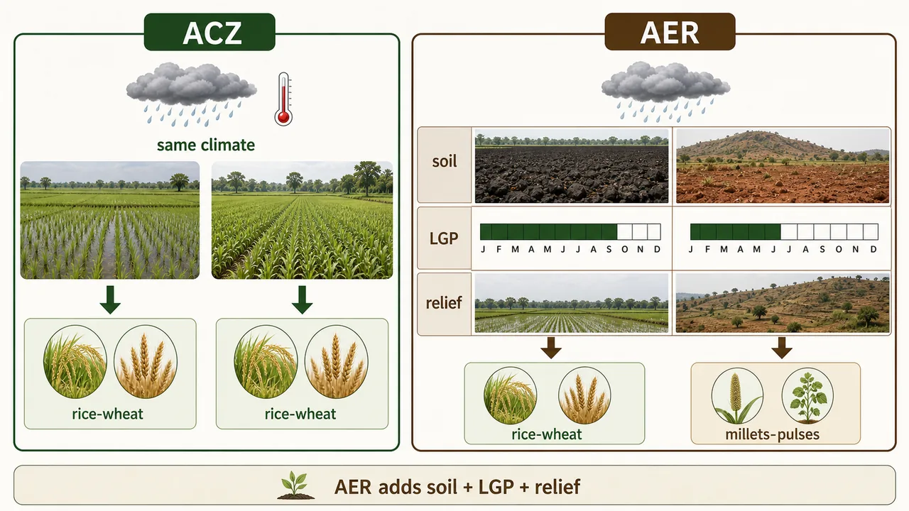
| Feature | ACZ (Planning Commission) | AER (NBSS&LUP) |
|---|---|---|
| Basis | Rainfall + temperature | Bioclimate + LGP + Soils + Physiography |
| Advantage | Good for broad planning | LGP directly indicates moisture availability for crops |
| Limitation | Does not capture soil variability | More complex to implement |
TIP
Exam tip: Two regions may receive the same total rainfall, but if one receives it over 4 months and the other over 8 months, their agricultural potential is vastly different. LGP captures this distinction, making AERs superior for crop planning.
LGP-Based Ecosystem Classification
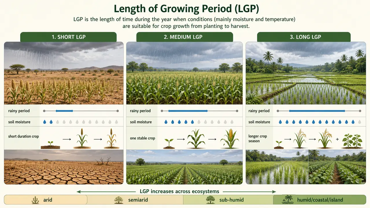
| LGP Idea | Meaning for Agriculture |
|---|---|
| Short LGP | Moisture is available for only a brief crop season, so drought-tolerant or short-duration crops are preferred |
| Medium LGP | Supports one stable seasonal crop and, in better soils or irrigated pockets, a wider crop choice |
| Long LGP | Moisture remains available for longer, allowing longer-duration crops and more intensive cropping systems |
Length of growing period links climate to cropping opportunity by showing how long moisture remains adequate for crops.
| System | LGP | Major Areas |
|---|---|---|
| Arid Ecosystem | Less than 90 days | Western Himalayas, Deccan plateau |
| Semiarid Ecosystem | 90-150 days | Central high lands, Gujarat plains, Kathiawar peninsula |
| Sub Humid Ecosystem | 150-180 days or 180-210 days | Eastern Plateau (Chotanagpur) and Eastern Ghats hot sub-humid eco-region |
| Humid Per humid Ecosystem | 210+ | Bengal and Assam plain hot sub-humid |
| Coastal Ecosystem | 210+ | Eastern Coastal Plain, Western Ghat |
| Island Ecosystem | 210+ | Andaman Nicobar and Lakshadweep |
TIP
Zone → Production connection: Each zone's climate, soil, and water resources determine what India grows and how much. The next lesson quantifies this — India's production data, GVA trends, leading states, and global rankings are all direct consequences of this agro-climatic diversity. When you see "Punjab leads in wheat productivity," think Zone 6 (alluvial soil + irrigation + cool rabi). When you see "MP leads in pulses," think Zones 7-9 (dryland regur + red soils).
Summary Cheat Sheet
| Concept / Topic | Key Details / Explanation |
|---|---|
| India's food grain record | 353.96 million tonnes for 2024-25 (3rd advance estimate); India feeds nearly 18% of world population on 2.4% of world area |
| Agro-Climatic Zone (ACZ) | Land unit uniform in climate and LGP, suitable for specific crops (FAO, 1983) |
| Length of Growing Period (LGP) | Days when both moisture and temperature are adequate for crop growth |
| Classification factors | Climatic (rainfall, temp), Soil (type, pH), Physiographic (topography), Agronomic (cropping pattern), Resources (irrigation) |
| Planning Commission ACZs | 15 zones, 73 sub-zones (1988-89); basis: rainfall, temperature, topography, cropping & farming systems |
| ICAR NARP ACZs | 127 zones (1980); basis: rainfall pattern, cropping pattern, admin units; enables location-specific research |
| Max NARP ACZs in a state | MP & Chhattisgarh (12), followed by Odisha & Karnataka (10 each) |
| NBSS&LUP AERs | 20 regions, 60 sub-zones; basis: Bioclimate + LGP + Soils + Physiography (FAO 1978 concept) |
| ACZ vs AER | AER superior — uses LGP which captures moisture availability; ACZ only uses rainfall + temperature |
| Zone 1: Western Himalayan | J&K, HP, Uttarakhand; 1650-2000 mm; apple, saffron, rice, wheat; lowest cropping intensity in J&K |
| Zone 2: Eastern Himalayan | NE states, Sikkim, parts of WB; 1840-3528 mm; Jhuming (shifting cultivation); tea, rice |
| Zone 3: Lower Gangetic | West Bengal; 1302-1607 mm; major rice-jute zone; in 2023-24, Telangana and UP were ahead of West Bengal in rice production |
| Zone 4: Middle Gangetic | Eastern UP, Bihar; 1211-1470 mm; sugarcane, paddy; 40% irrigated, CI 142% |
| Zone 5: Upper Gangetic | Western UP; 721-979 mm; major sugarcane zone; UP leads in sugarcane production & total food grain area |
| Zone 6: Trans-Gangetic | Punjab, Haryana, Delhi, Chandigarh; highest cropping intensity in India; "Granary of India"; wheat & rice productivity leader |
| Zone 7: Eastern Plateau & Hills | E-MP, Jharkhand, Chhattisgarh, inland Odisha, uplands of WB; red & yellow soils; largest ACZ; MP dominates pulses & oilseeds |
| Zone 8: Central Plateau & Hills | 46 districts of MP, UP, Rajasthan; 400-1550 mm; wheat, gram, jowar; water-scarce ravines |
| Zone 9: Western Plateau & Hills | Maharashtra, parts of MP; Regur (black cotton) soil; 50% of India's jowar; Maharashtra leads sorghum |
| Zone 10: Southern Plateau & Hills | Karnataka, Telangana, Rayalaseema (AP), TN uplands; coffee, tea, spices; 81% dryland farming; CI 111% |
| Zone 11: East Coast Plains | Odisha, AP, TN, Pondicherry; alluvial + coastal sands; 20.3% of rice, 17.5% of groundnut; 75% rainfed |
| Zone 12: West Coast Plains & Ghats | TN, Kerala, Goa, Karnataka, Maharashtra; wettest ACZ (2226-3640 mm); laterite soil; spices, plantation crops |
| Zone 13: Gujarat Plains & Hills | Gujarat; 340-1793 mm (wide range); oilseed region; leads in groundnut, cotton, tobacco; 60% drought-prone |
| Zone 14: Western Dry Region | 9 districts of Rajasthan; driest ACZ (~95 mm); bajra, gram; 1.2% forest, 6.3% irrigated, CI 105% |
| Zone 15: Island Region | A&N, Lakshadweep; ~3000 mm; humid tropical maritime; nearly half cropped area under coconut |
| Zone grouping mnemonic | WEL-MUT EC-WS EW-GWI → Himalayan (2), Gangetic (4), Plateau (4), Coastal (2), Others (3) |
| LGP < 90 days (Arid) | W. Himalayas, Deccan plateau |
| LGP 90-150 days (Semi-Arid) | Central highlands, Gujarat plains, Kathiawar |
| LGP 150-210 days (Sub-Humid) | Eastern Plateau (Chotanagpur), Eastern Ghats |
| LGP 210+ days (Humid/Per-Humid) | Bengal & Assam plains |
| LGP 210+ days (Coastal) | Eastern Coastal Plain, Western Ghats |
| LGP 210+ days (Island) | Andaman Nicobar, Lakshadweep |
| First fully organic state | Sikkim (Eastern Himalayan Region) |
Exam Focus Areas
For exam recall, prioritize these high-frequency linkages:
- Count-based traps: 15 ACZ (Planning Commission), 127 NARP (ICAR), 20 AER (NBSS&LUP), and their basis differences.
- Zone-state-crop mapping: Western Dry Region → bajra/gram; Trans-Gangetic → wheat-rice; West Coast Plains & Ghats → spices/plantation crops.
- Concept distinction: ACZ is broader planning logic; AER is more scientific and LGP-driven.
- LGP logic: short-LGP regions favor drought-tolerant or short-duration crops; long-LGP regions support longer-duration and intensive cropping.
- Wettest vs driest zone framing: West Coast Plains & Ghats versus Western Dry Region.
References
3 sources • [1] [2] [3]
References
Used for: current foodgrain, rice, and sugarcane figures
Used for: state-wise production tables for rice and all-India sugarcane totals
Used for: updated zone-state framing including Telangana, Jharkhand, and Chhattisgarh
Frequently Asked Questions
How many agro-climatic zones are there in India?
India has 15 major agro-climatic zones under the Planning Commission classification, 127 zones under ICAR-NARP, and 20 agro-ecological regions under NBSS&LUP.
Who classified India into 15 agro-climatic zones?
The Planning Commission (1988-89), with NRSA support, classified India into 15 broad agro-climatic regions for regional agricultural planning.
What is the difference between ACZ and AER?
ACZ focuses mainly on climate and broad planning variables, while AER includes bioclimate, soils, physiography, and length of growing period (LGP), making it more detailed for land-use decisions.
What is LGP in agro-climatic classification?
LGP (Length of Growing Period) is the number of days when both moisture and temperature are adequate for crop growth.
Which region is the wettest and which is the driest among 15 ACZs?
The West Coast Plains and Ghats are among the wettest, while the Western Dry Region of Rajasthan is the driest.
Why are agro-climatic zones important for exams?
Exam questions frequently test zone-state-crop links, dryland versus humid farming logic, and comparative facts such as ACZ vs AER and LGP classes.