🌊 Watershed Management: Principles, Programmes, and Practices for Rainfed Agriculture
Complete guide to watershed management -- definition, types, objectives, four phases, major Indian programmes (DPAP, DDP, NWDPRA, WDC-PMKSY, Neeranchal), management practices, rainwater harvesting, and water budgeting for competitive exams.
A Village That Stopped Water From Leaving
In the previous lesson, we covered dryland agriculture -- the crops, institutions (CRIDA, ICRISAT), contingency plans, and drought management strategies for farming without irrigation. Now we zoom out to the landscape level: how do we manage an entire drainage area to conserve rainfall for an entire community?
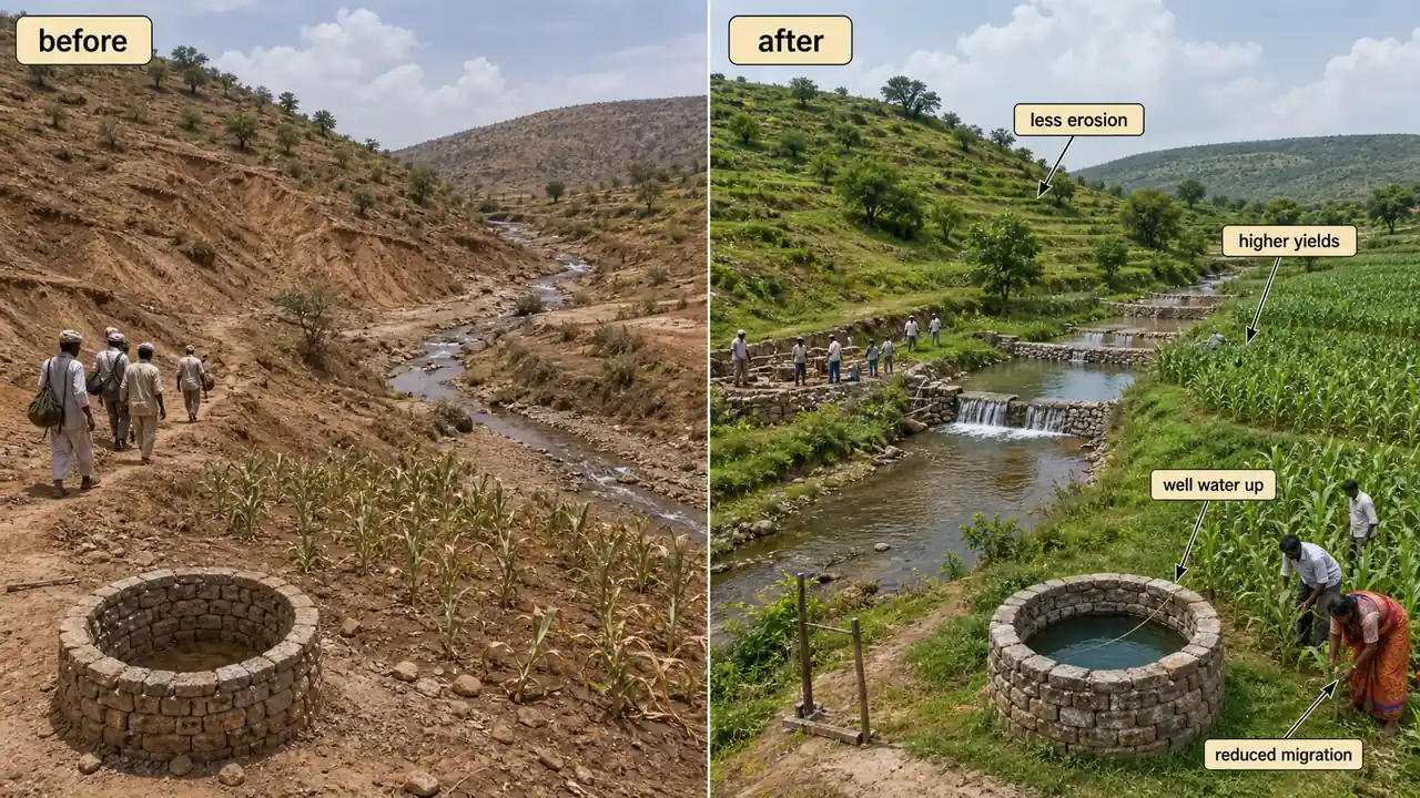
In Ralegan Siddhi, a small village in drought-prone Ahmednagar district of Maharashtra, farmers once struggled with failed monsoons, depleted wells, and mass migration. Then the village collectively built check dams, contour bunds, and percolation tanks across its watershed. Within a decade, groundwater levels rose by 5 metres, cropping intensity doubled, and migration stopped. This transformation was not magic -- it was watershed management, the science of treating an entire drainage area as one unit to conserve every drop of rain where it falls. For rainfed agriculture, which covers over half of India's cultivated area, watershed management is the most powerful tool available.
Pro Content Locked
Upgrade to Pro to access this lesson and all other premium content.
Charged once for one year · ₹1188 total
Save ₹100/month vs ₹2388/year launch price
- All Agriculture & Banking Courses
- AI Lesson Questions (100/day)
- AI Doubt Solver (50/day)
- Glows & Grows Feedback (30/day)
- AI Section Quiz (20/day)
- 22-Language Translation (100/day)
- Recall Questions (20/day)
- AI Quiz (15/day)
- AI Quiz Paper Analysis (100/day)
- AI Step-by-Step Explanations (100/day)
- Spaced Repetition Recall (FSRS)
- AI Tutor
- Immersive Text Questions
- Audio Lessons — Hindi & English
- Mock Tests & Previous Year Papers
- Summary & Mind Maps
- XP, Levels, Leaderboard & Badges
- Generate New Classrooms
- Voice AI Teacher (AgriDots Live)
- AI Revision Assistant
- Knowledge Gap Analysis
- Interactive Revision (LangGraph)
🔒 Secure one-time yearly payment via Razorpay · No hidden fees
A Village That Stopped Water From Leaving
In the previous lesson, we covered dryland agriculture -- the crops, institutions (CRIDA, ICRISAT), contingency plans, and drought management strategies for farming without irrigation. Now we zoom out to the landscape level: how do we manage an entire drainage area to conserve rainfall for an entire community?
In Ralegan Siddhi, a small village in drought-prone Ahmednagar district of Maharashtra, farmers once struggled with failed monsoons, depleted wells, and mass migration. Then the village collectively built check dams, contour bunds, and percolation tanks across its watershed. Within a decade, groundwater levels rose by 5 metres, cropping intensity doubled, and migration stopped. This transformation was not magic -- it was watershed management, the science of treating an entire drainage area as one unit to conserve every drop of rain where it falls. For rainfed agriculture, which covers over half of India's cultivated area, watershed management is the most powerful tool available.
What is a Watershed?
A watershed is an area of land where all the rainwater that falls within its boundaries flows downhill to converge at a single outlet point -- a stream, river, lake, or ocean. The boundary separating one watershed from its neighbour is called the drainage divide (or ridge line).
- The term "watershed" was introduced in 1920 for "water parting boundaries".
- Formally defined as a geohydrological unit draining to a common point by a system of drains.
- Watershed technology is used primarily in rainfed areas. Since rainfed areas cannot rely on external water sources, managing the rainfall that falls within the watershed boundary is the only way to ensure water availability for crops, livestock, and domestic use.
- Catchment area is the water collecting area -- "all the areas from which water flows out into a river or water pool".
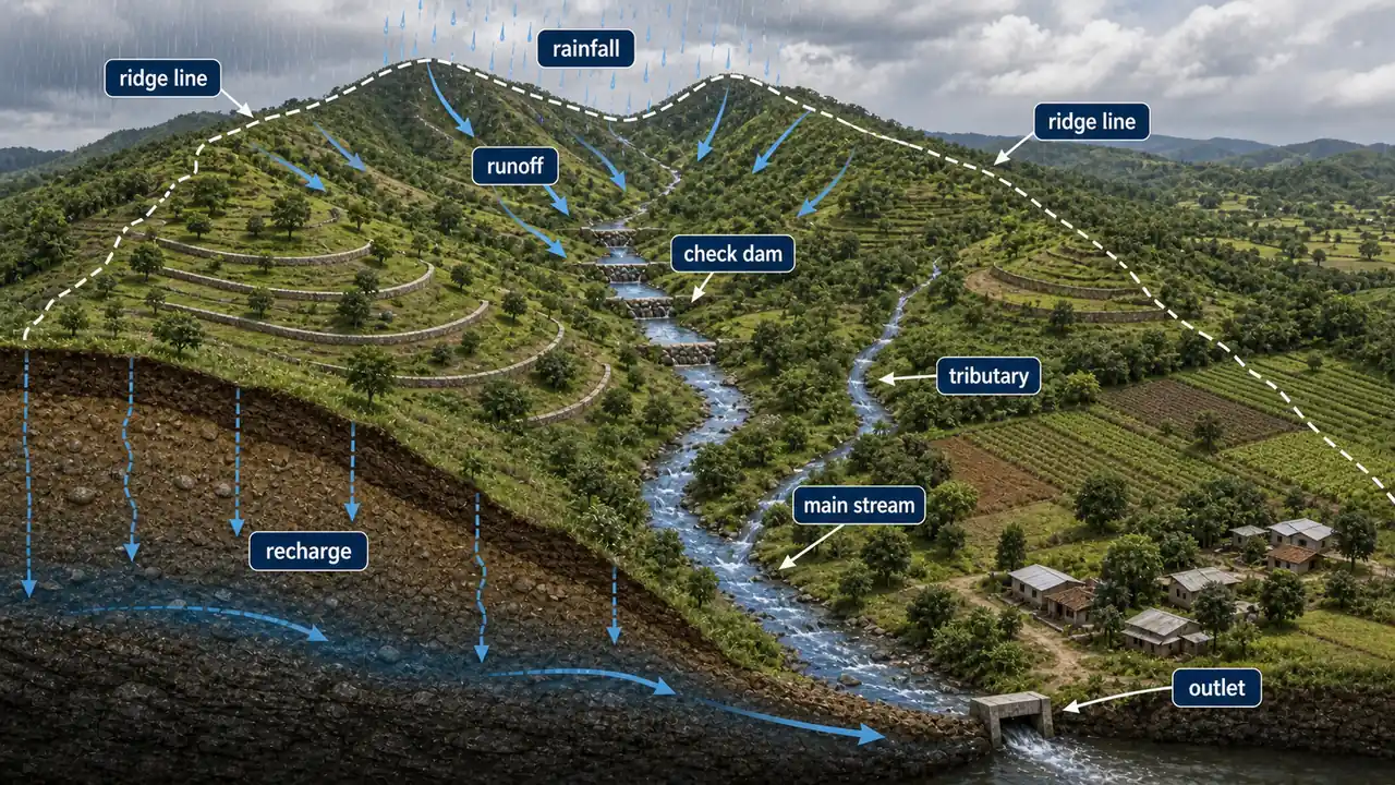
Agricultural example: A micro-watershed of 500 hectares in Madhya Pradesh's Dewas district receives an average of 900 mm rainfall annually. Without management, 40% runs off as surface flow, eroding topsoil and leaving wells dry by February. With watershed treatment (contour bunds, farm ponds, vegetative barriers), runoff is reduced to 15%, wells sustain water until May, and farmers grow a second rabi crop.
TIP
Exam fact: Watershed is also called a hydrological unit. Remember: a watershed is defined by topography (ridge lines), not by administrative boundaries (village/district limits).
What is Watershed Management?
Watershed management is the effective conservation of soil and water resources for sustainable production with minimum non-point source (NPS) pollutant losses. It involves managing land surface and vegetation to conserve soil and water for immediate and long-term benefits to farmers, community, and society.
The approach is holistic -- it considers the entire watershed as an integrated system where activities in the upper reaches affect conditions downstream, and management decisions must account for these interconnections.
Agricultural example: If farmers in the upper part of a watershed clear forests for cultivation, the increased runoff causes flooding and silt deposition in the lower fields. Watershed management prevents this by treating the entire area -- planting trees at the top, building check dams in the middle, and improving drainage at the bottom.
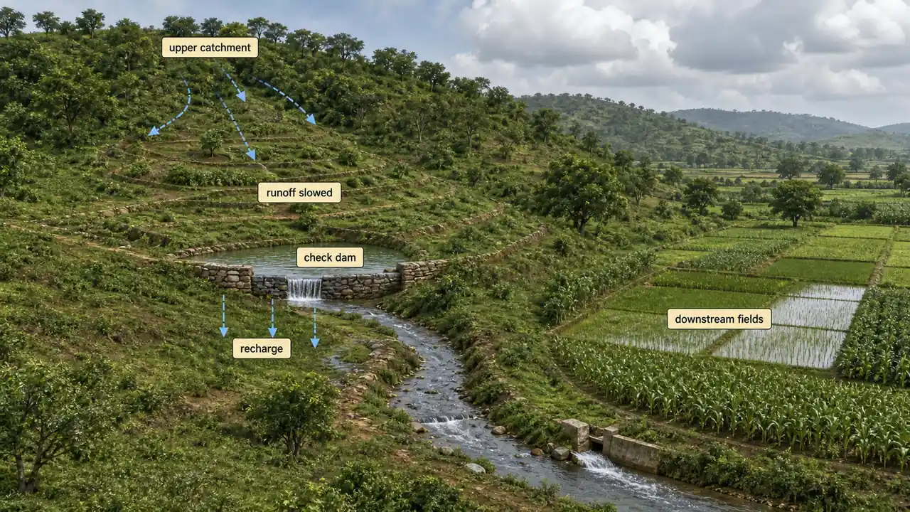
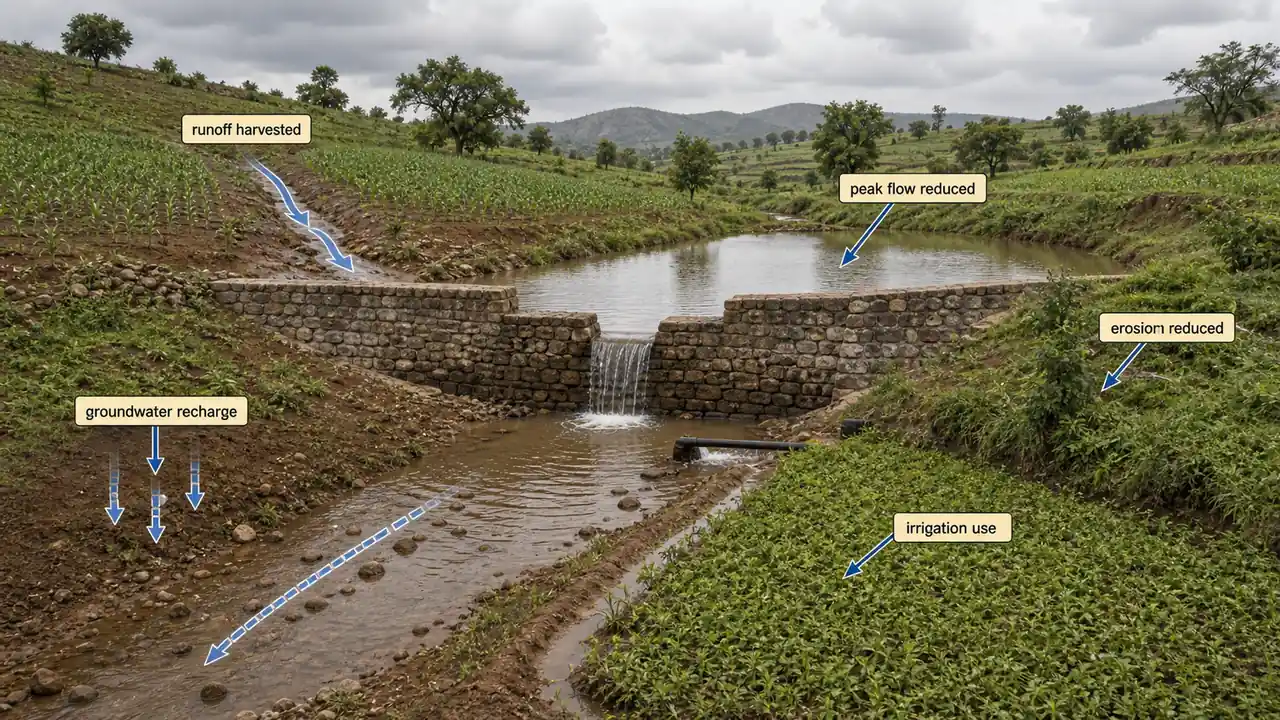
Aims of Watershed Construction
Watershed structures serve two complementary purposes:
| Aim | How It Works | Agricultural Benefit |
|---|---|---|
| Harvest maximum runoff water | Collect and store surface runoff throughout the year | Provides water for irrigation and drinking |
| Reduce peak runoff rate | Slow down water flow using structures and vegetation | Minimises soil erosion, increases groundwater recharge |
By slowing down runoff and allowing more water to infiltrate into the soil, watershed structures simultaneously reduce erosion, recharge aquifers, and improve base flow in streams.
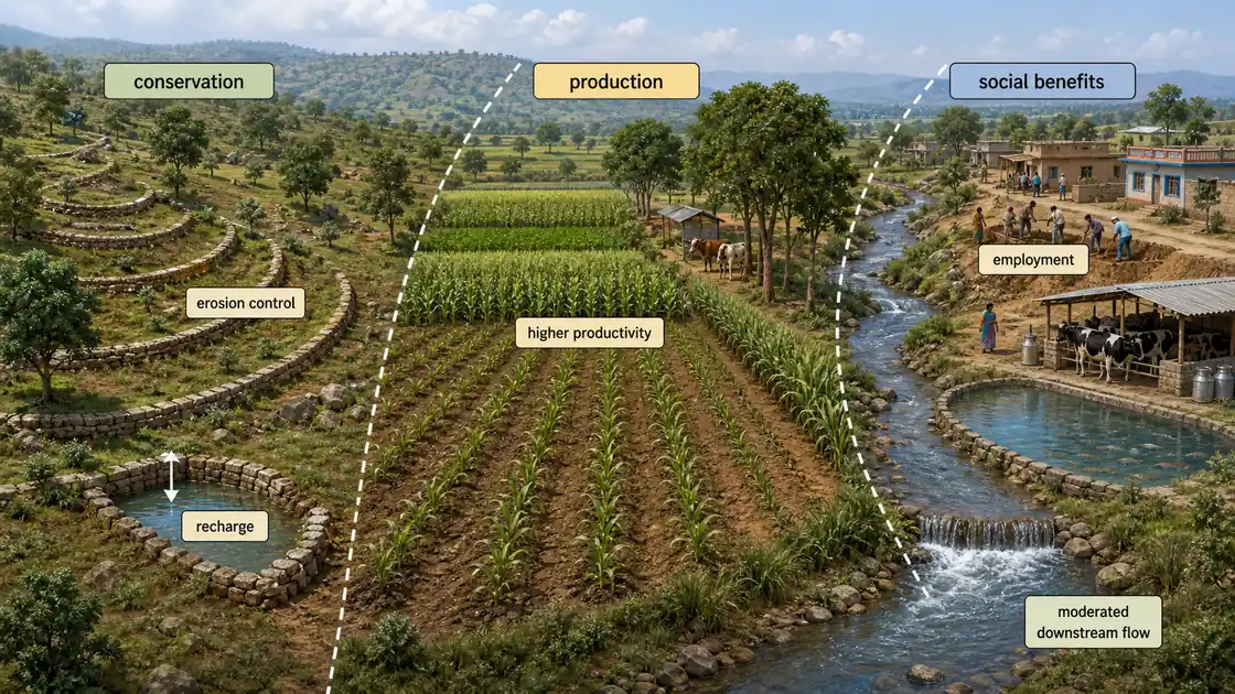
Objectives of Watershed Management
- Control damaging runoff and conserve soil and water (in-situ conservation of soil moisture)
- Increase gross cropped area, production, and productivity
- Protect, conserve, and improve watershed land for sustained production
- Protect and enhance water resources originating in the watershed
- Check soil erosion and reduce sediment yield
- Rehabilitate deteriorating and degraded lands
- Moderate flood peaks at downstream areas
- Increase infiltration of rainwater
- Improve production of timber, fodder, and wildlife resources
- Enhance groundwater recharge wherever applicable
- Generate employment through industrial development, dairy, and fishery production
- Provide recreational facilities
TIP
Exam shortcut: The objectives can be grouped into three themes: Conservation (soil, water, land -- objectives 1, 4, 5, 6, 8, 10), Production (crops, timber, fodder -- objectives 2, 3, 9), and Social (employment, flood control, recreation -- objectives 7, 11, 12).
Impact of Watershed Development
Successful watershed development programmes have demonstrated significant positive impacts:
| Impact Area | Specific Outcome |
|---|---|
| Cultivated area | Increase in area under cultivation |
| Crop productivity | Increase in yields of various crops |
| Groundwater | Well water levels rise by 2--5 metres in treated watersheds |
| Net sown area | Increase in both sown and irrigated area |
| Cropping intensity | Second and even third crops become possible with improved moisture |
| Migration | Reduced distress migration due to employment creation |
| Soil erosion | Significant decrease in soil loss |
Agricultural example: The Sukhomajri watershed project in Haryana's Shivalik hills is a landmark success. Before treatment, the village lost 150 tonnes of soil per hectare per year. After building check dams and establishing community-managed grazing rules, soil loss dropped to less than 5 tonnes, and crop yields tripled.
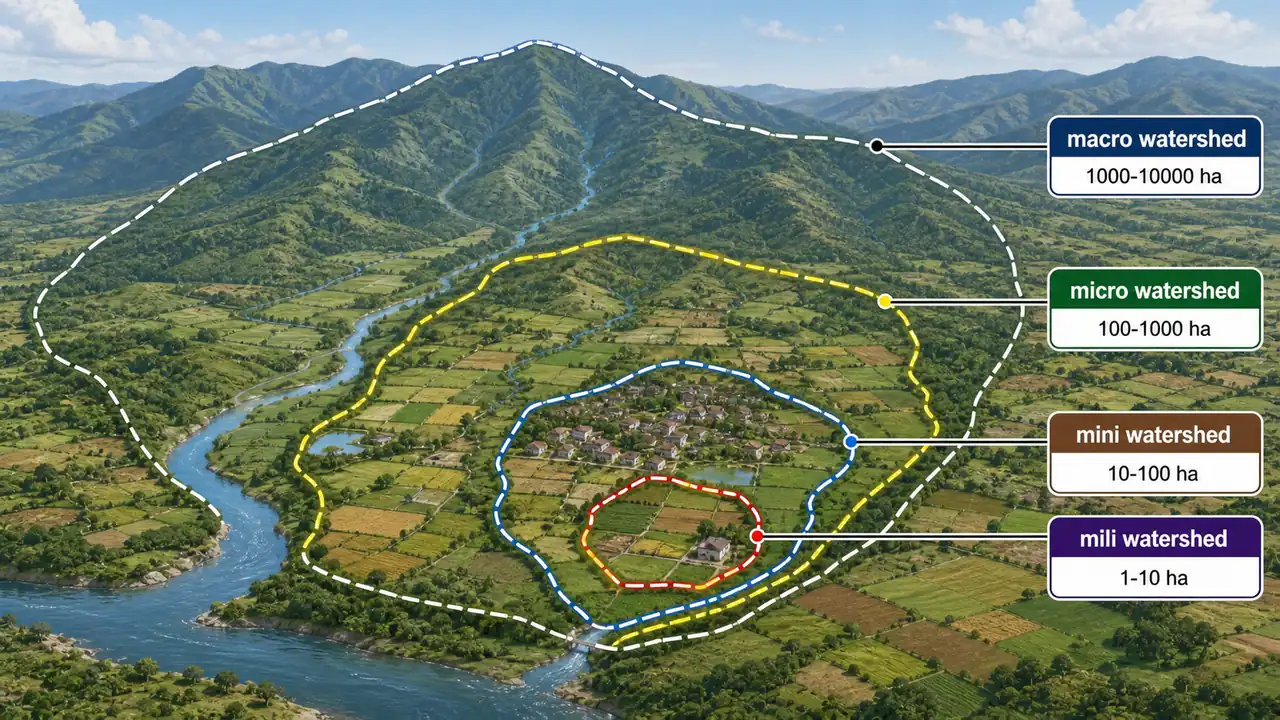
Types of Watershed
Watersheds are classified depending upon size, drainage, shape, and land use pattern.
| Type | Size | Planning Use |
|---|---|---|
| Macro watershed | 1000 -- 10,000 ha | Regional planning |
| Micro watershed | 100 -- 1000 ha | Most commonly used for project implementation UPPSC 2021 |
| Mini watershed | 10 -- 100 ha | Village-level treatment |
| Mili watershed | 1 -- 10 ha | Individual farm-level |
The micro watershed (100--1000 ha) is the most commonly used unit for planning and implementing watershed development projects in India, as it is large enough to show measurable impact yet small enough for effective community-based management.
NOTE
Alternate large-scale classification used by some agencies:
- Macro watershed: > 50,000 Hectare
- Sub-watershed: 10,000 to 50,000 Hectare
- Milli-watershed: 1,000 to 10,000 Hectare
- Micro watershed: 100 to 1,000 Hectare
- Mini watershed: 1--100 Hectare
TIP
Exam mnemonic -- "Ma-Mi-Mi-Mi": From largest to smallest: Macro (1000--10,000), Micro (100--1000), Mini (10--100), Mili (1--10). Each is roughly 10x smaller than the previous. The most asked is micro watershed = 100--1000 ha.
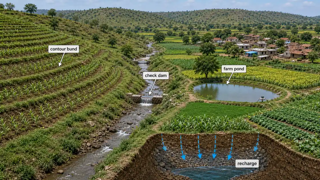
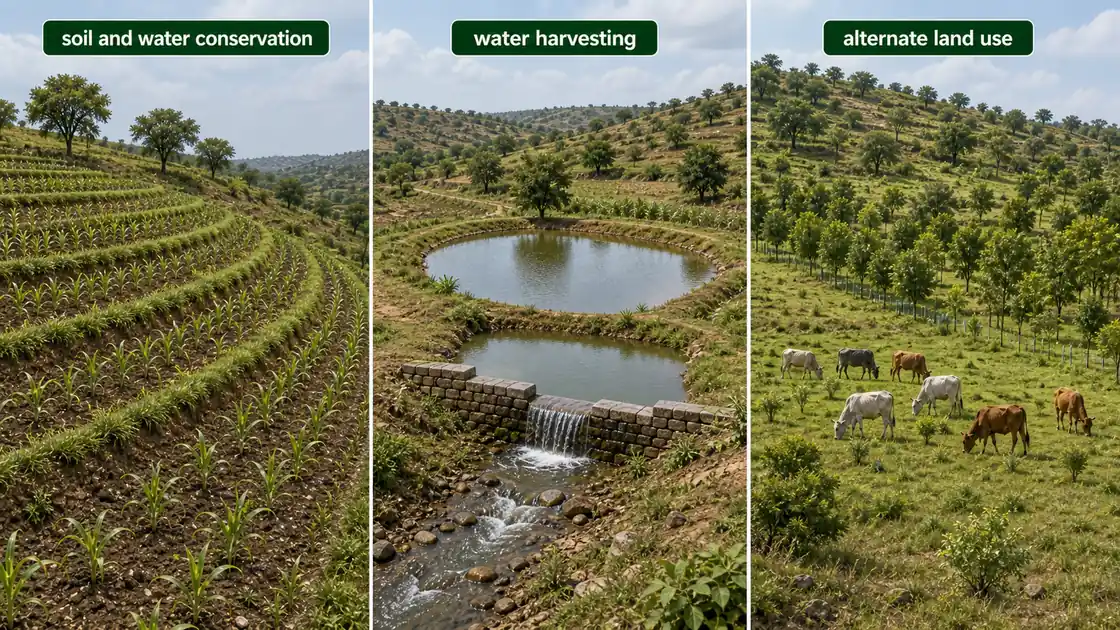
Main Components of Watershed Management
| Component | What It Covers | Agricultural Example |
|---|---|---|
| Soil and water conservation | Reducing erosion and improving in-situ moisture | Contour bunding, terracing in sloping fields |
| Water harvesting and management | Capturing and storing excess runoff | Farm ponds, check dams, percolation tanks |
| Alternate land use system | Directing non-arable land to productive uses | Agro-forestry, pasture, horticulture on marginal lands |
These three components work together in a complementary manner -- soil conservation reduces erosion and improves in-situ moisture, water harvesting captures and stores excess runoff, and alternate land use directs non-arable land towards productive uses.
Four Phases of Watershed Management
Watershed management follows a logical sequence from problem identification to long-term enhancement. Understanding these phases is essential for both implementation and exams.
| Phase | Purpose | Key Activities |
|---|---|---|
| 1. Recognition | Identify problems and causes | Soil survey, land capability survey, agronomic survey, forest survey, engineering and socio-economic surveys |
| 2. Restoration | Implement solutions | Apply biological measures (vegetative barriers, afforestation) and engineering measures (bunds, terraces, check dams) starting with critical areas |
| 3. Protection | Maintain what was built | Protect against factors that may cause deterioration; ensure normal functioning |
| 4. Improvement | Enhance overall development | Agriculture and forest management, forage and pasture management, socio-economic improvement (health, dairy, poultry) |
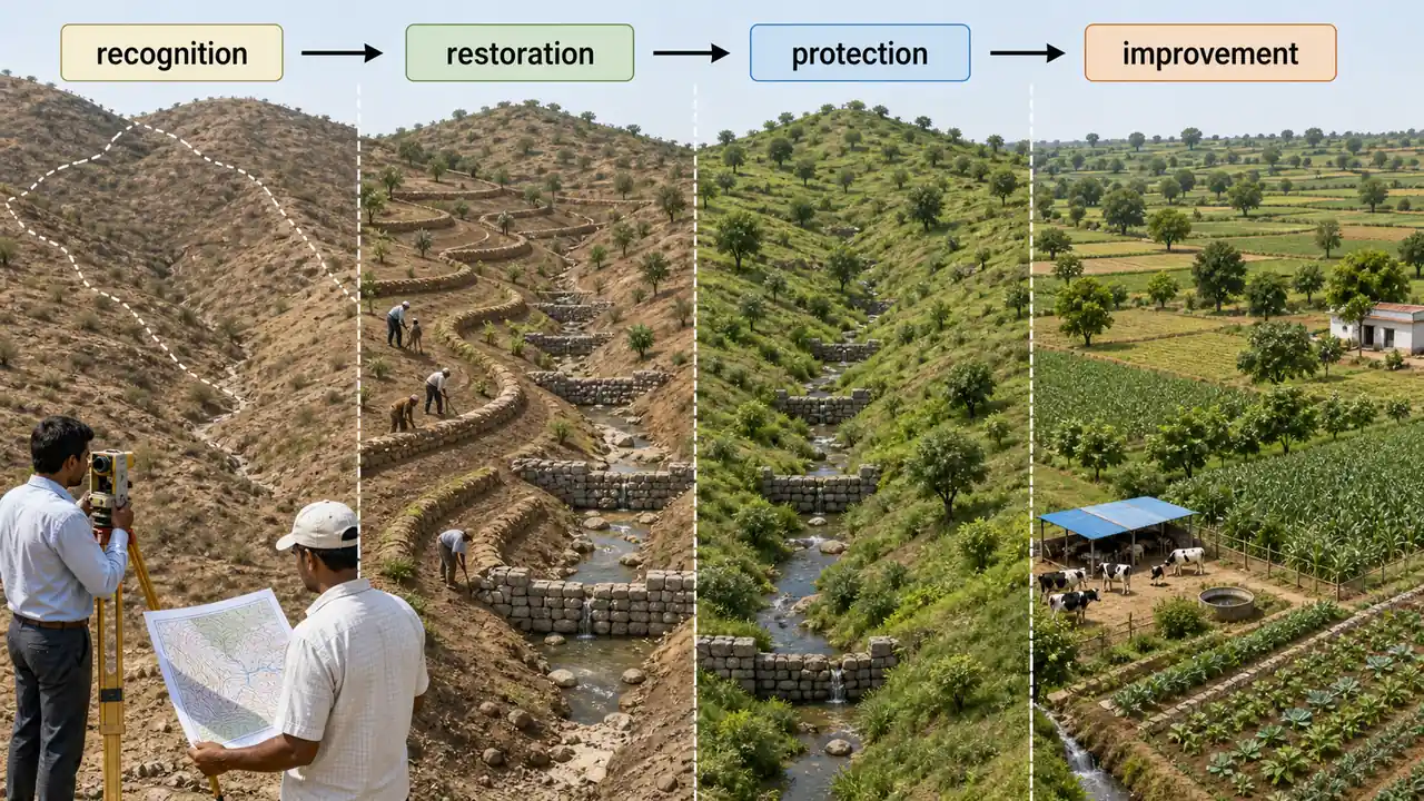
TIP
Exam mnemonic -- "RRPI": The four phases in order: Recognition, Restoration, Protection, Improvement. Think of it as: first you Recognise the problem, then Restore the land, then Protect the gains, then Improve further.
Phase Details
Recognition Phase: This is essentially a diagnostic exercise that establishes the baseline condition of the watershed. Information is obtained from different surveys (soil, land capability, agronomic, forest, engineering, socio-economic) to identify watershed problems, set priorities for land treatment, and understand causes and effects on land and people.
Restoration Phase: Involves actual on-the-ground implementation starting with the most degraded areas. Biological measures include vegetative barriers, contour planting, and afforestation. Engineering measures include bunds, terraces, check dams, and farm ponds.
Protection Phase: Focuses on maintaining structures and measures already in place. Without regular maintenance, check dams silt up, bunds break, and the benefits of restoration are quickly lost.
Improvement Phase: Goes beyond physical land treatment to address broader socio-economic development -- recognizing that sustainable natural resource management requires improvements in human welfare (health, employment, livestock improvement).
Watershed Management Programmes in India
India has implemented several major watershed development programmes over the decades. Each targets specific agro-ecological challenges.
Programme Comparison Table
| Programme | Year Started | Focus Area | Key Objective |
|---|---|---|---|
| DPAP | 1970--71 | Drought-prone regions | Restore ecological balance; optimise land, water, livestock use |
| DDP | 1977--78 | Hot and cold deserts | Combat desertification; sand dune stabilisation |
| NWDPRA | 1986--87 | Rainfed agriculture | Conserve rainwater on watershed basis; alternate land use |
| World Bank IWDP | 1990 | Degraded environments | Arrest degradation; promote sustainable agriculture |
| WDC-PMKSY | 2009 (as IWMP) | Rainfed cultivated area | "Har Khet Ko Pani" and "More Crop Per Drop" |
| Neeranchal | 2016--21 | Rainfed areas | Reduce runoff; increase groundwater recharge |
TIP
Exam mnemonic -- chronological order: "D-D-N-W-P-N" -- DPAP (1970), DDP (1977), NWDPRA (1986), World Bank (1990), PMKSY-WDC (2009), Neeranchal (2016). Remember the decades: 70s, 70s, 80s, 90s, 2000s, 2010s.
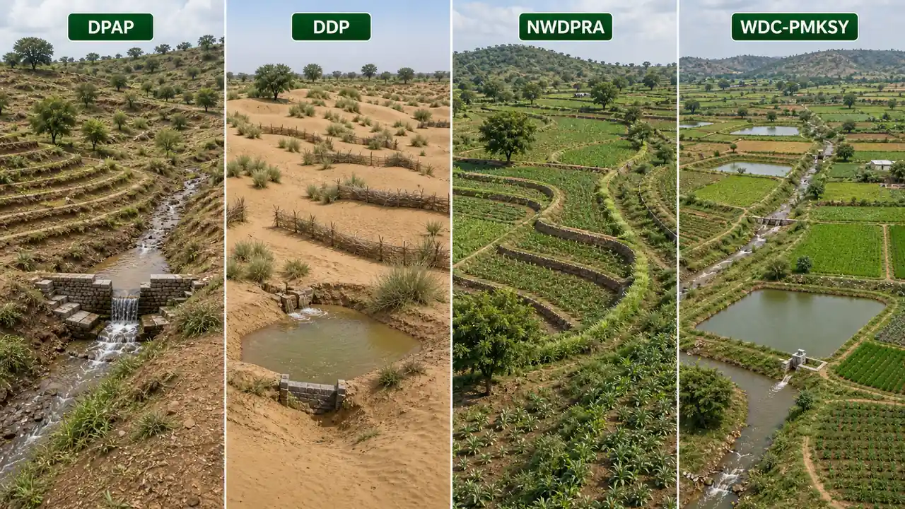
1. Drought Prone Area Programme (DPAP)
- Year of start: 1970--71
- Objectives: Area development through restoration of ecological balance and optimum utilization of land, water, livestock, and human resources to mitigate the effect of drought.
- DPAP was one of the earliest area development programmes specifically designed for drought-prone regions.
2. Desert Development Programme (DDP)
- Year of start: 1977--78
- Objectives: Mitigate the effect of drought in desert areas and restore ecological balance.
- DDP targets the hot and cold desert areas of the country, focusing on combating desertification through afforestation, sand dune stabilisation, and water harvesting.

3. National Watershed Development Programme for Rainfed Agriculture (NWDPRA)
- Year of start: 1986--87
- Objectives: To conserve and utilise rainwater from both arable and non-arable lands on watershed basis. To increase the productivity of crops and to increase fuel, fodder, and fruit resources through appropriate alternate land use systems.
4. World Bank Assisted Integrated Watershed Development Programme
- Year of start: 1990
- Objectives: To arrest problems of environmental degradation and promote sustainable increase in agriculture production. To enhance vegetative technology of soil and water conservation for rainwater conservation and for increasing crop, forage, fuel wood, and timber yield.
5. Watershed Development Component of Pradhan Mantri Krishi Sinchai Yojana (WDC-PMKSY)
The Department of Land Resources, Ministry of Rural Development, implemented the Integrated Watershed Management Programme (IWMP) from 2009 for development of rainfed portions of net cultivated area and culturable wastelands.
Activities include: ridge area treatment, drainage line treatment, soil and moisture conservation, rainwater harvesting, nursery raising, afforestation, horticulture, pasture development, and livelihoods for asset-less persons.
IWMP was subsumed under PMKSY as one of its components, integrating watershed development with the national vision of "Har Khet Ko Pani" (water to every field) and "More Crop Per Drop" (water use efficiency). Operational guidelines approved on 26.10.2015.
Salient Features of WDC-PMKSY
| Feature | Detail |
|---|---|
| Project size | Cluster approach; average ~5,000 ha |
| Cost norms | Rs 12,000/ha (plains); Rs 15,000/ha (hilly/difficult areas) |
| Funding pattern | 90:10 (Centre : State) |
| Central assistance | Three instalments (20%, 50%, 30%) |
| Project period | 4 to 7 years (flexible) |
| Planning tools | IT, remote sensing, GIS for planning, monitoring, and evaluation |
| Fund earmarking | OPR preparation (1%), Entry point activities (4%), Capacity building (5%), Monitoring (1%), Evaluation (1%) |
| Livelihood component | 9% for livelihoods for asset-less people; 10% for production systems and micro-enterprises |
| Delegation | States empowered to sanction projects |
TIP
Exam fact: WDC-PMKSY doubled cost norms from Rs 6,000 to Rs 12,000/ha (plains) and Rs 15,000/ha (hills). The slogans "Har Khet Ko Pani" and "More Crop Per Drop" are frequently asked.
6. Neeranchal National Watershed Project
- Implementation period: 2016--21 (six years)
- Implemented by the Ministry of Rural Development
- Budget sharing: 50% Government + 50% World Bank
- Objectives: Reduce surface runoff, increase groundwater recharge, enhance rainfed agriculture productivity, increase milk yield, and improve cropping intensity
- Supports PMKSY in hydrology and water management, agricultural production systems, capacity building, monitoring, and evaluation
Agricultural example: Under Neeranchal, treated watersheds in Madhya Pradesh showed a 35% increase in groundwater levels and a shift from single-crop to double-crop farming, with milk production increasing as improved fodder availability sustained more livestock through the dry season.
Watershed Management Practices
A. By Purpose
| Purpose | Practices Used |
|---|---|
| Increase infiltration | Contour bunding, mulching, conservation tillage |
| Increase water holding capacity | Farm ponds, percolation tanks, check dams |
| Prevent soil erosion | Vegetative barriers, terracing, grassed waterways |
B. By Method
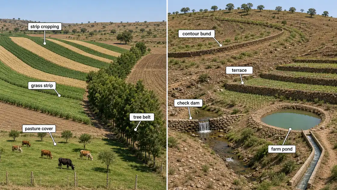
Vegetative Measures (Agronomical)
| Practice | How It Works |
|---|---|
| Strip cropping | Alternating strips of crops along contours to slow runoff |
| Pasture cropping | Establishing perennial grasses to protect soil |
| Grassland farming | Converting degraded land to grass cover |
| Woodlands | Planting trees on non-arable land for soil binding |
Vegetative measures use living plants as the primary tool for soil and water conservation. They are generally less expensive than engineering structures and provide additional economic benefits through crop, fodder, or timber production.
Engineering Measures (Structural Practices)
| Structure | Function |
|---|---|
| Contour bunding | Intercepts runoff along contours |
| Terracing | Creates level platforms on slopes |
| Earthen embankment | Stores water behind earthen walls |
| Check dam | Slows water flow in drainage channels |
| Farm ponds | Stores harvested rainwater for irrigation |
| Diversion channels | Redirects excess water safely |
| Gully control structures | Prevents gully erosion from expanding |
| Zing terracing | Cuts slope length on 3-10% gradients to harvest runoff for crops on lower terraces — dryland moisture conservation |
| Rock dams | Permanent structures in stream beds |
| Vegetative and stone barriers | Filters sediment from runoff |
Engineering measures physically intercept, divert, or store runoff water. While more expensive to build, they provide immediate and reliable results in controlling erosion and harvesting water.
Vegetative vs Engineering Measures -- Comparison
| Feature | Vegetative Measures | Engineering Measures |
|---|---|---|
| Cost | Low | High |
| Speed of results | Slow (plants need to grow) | Immediate |
| Maintenance | Self-sustaining once established | Requires regular maintenance |
| Additional benefits | Fodder, timber, fruit production | Water storage and harvesting |
| Durability | Long-term if maintained | Can silt up or break without maintenance |
| Best for | Moderate slopes, arable land | Steep slopes, drainage lines, gullies |
Rainwater Harvesting
Rainwater harvesting means collection and storage of rainwater by some mechanism to make water available for future use. It encompasses any technique -- from simple farm ponds to rooftop collection systems -- that captures rain for later use.
An appreciable amount of precipitation that is generally lost as surface flow can be harvested and stored for useful purposes like drinking and providing supplemental irrigation to crops.
Agricultural example: In Rajasthan's Thar Desert, traditional tanka (underground cistern) systems harvest rooftop and surface runoff to provide drinking water for 8--10 months. For agriculture, khadins (earthen embankments across gentle slopes) harvest runoff to create moisture-rich fields for growing wheat and chickpea without any external irrigation.

Important Points for Exams
| Point | Detail |
|---|---|
| Watershed alternate name | Hydrological unit |
| Most important approach in micro watershed | Soil conservation, soil improvement, and storage of runoff water |
| Silt detention tanks | Water storage structures that recharge groundwater; used for protective irrigation |
| In-situ water harvesting | Potential life-saving measure under moisture stress |
| In-situ techniques | Contour cultivation, tied ridges, micro-catchments, conservation furrows |
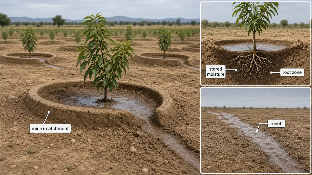
In-situ Water Harvesting
In-situ water harvesting means conserving rainwater right where it falls on the field, rather than allowing it to run off. This is the most cost-effective moisture conservation strategy for dryland farmers.
Micro-catchments are particularly beneficial because they:
- Increase moisture storage in deeper soil layers
- Are suitable for all soil types
- Are specifically effective for horticultural tree crops (mango, pomegranate, ber)
Agricultural example: In Karnataka's dryland belt, farmers create micro-catchments (small semi-circular bunds) around young mango trees. Each bund captures about 200 litres of rainwater per rain event, which percolates into the root zone. This simple technique improves survival rate of young trees from 50% to over 90%.
Water Budgeting
A water budget is a water management tool used to estimate the amount of water a landscape will require. It can be calculated for a single irrigation event, on a weekly or monthly basis, or even annually.
The water budget considers: reference evapotranspiration data, plant types, purpose and functionality of the landscape, irrigated landscape area, irrigation efficiency, water quality, and rainfall.
Community-Based Water Budgeting in Watersheds
Crop water budgeting is a community-led process where local communities come together to assess water resources in their village. The participatory nature is crucial because it builds community ownership and ensures all stakeholders -- large farmers, small farmers, landless labourers, women -- have a voice.
Communities explore three fundamental questions:
| Question | What It Determines |
|---|---|
| What is the quantity of water available in the village? | Supply side (rainfall + groundwater + surface storage) |
| What is the quantity of water used in the village? | Demand side (irrigation + domestic + livestock) |
| What is the balance of water available? | Surplus or deficit status |
- Positive balance (surplus): The village has more water than it uses -- can consider expanding irrigated area.
- Negative balance (deficit): Over-exploitation of water -- must reduce demand (less water-intensive crops) or increase supply (more harvesting structures).
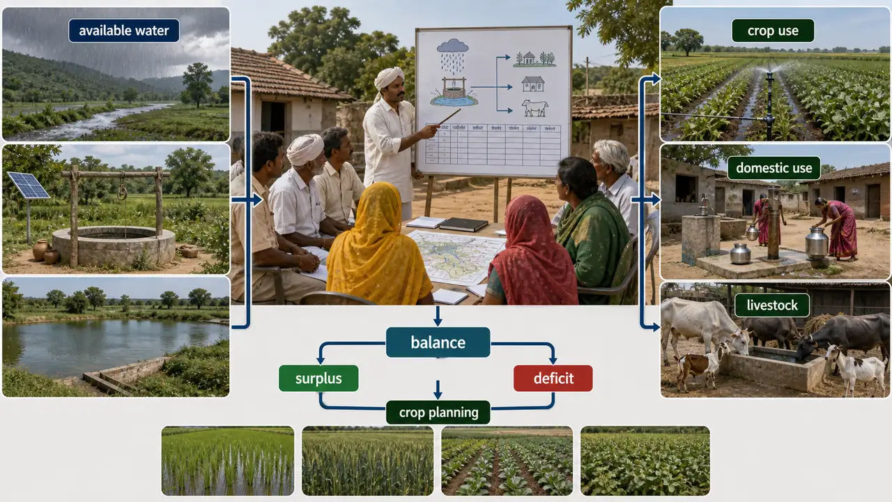
Agricultural example: In semi-arid villages of Andhra Pradesh, communities monitor groundwater levels bi-monthly using water level indicators. The data is publicly displayed. Before rabi sowing, crop plans are made based on available water -- securing enough for livestock and domestic use in summer before allocating the rest to irrigation. If water is scarce, farmers switch from water-intensive paddy to drought-tolerant millets or pulses.
TIP
Exam tip: Water budgeting answers three questions: How much water do we HAVE? (supply), How much do we USE? (demand), What is the BALANCE? (surplus or deficit). Community-led water budgeting is a key feature of modern watershed programmes.
Summary Table
| Topic | Key Point |
|---|---|
| Watershed | Geohydrological unit draining to a common point; also called hydrological unit |
| Watershed management | Conservation of soil and water for sustainable production; holistic approach |
| Main aims | Harvest maximum runoff + reduce peak runoff for groundwater recharge |
| Three components | Soil and water conservation, water harvesting, alternate land use |
| Four phases | Recognition, Restoration, Protection, Improvement (RRPI) |
| Micro watershed | 100--1000 ha; most commonly used planning unit |
| Mili watershed | 1--10 ha (smallest) |
| DPAP | 1970--71; drought-prone areas |
| DDP | 1977--78; hot and cold deserts |
| NWDPRA | 1986--87; rainfed agriculture |
| WDC-PMKSY | Rs 12,000/ha (plains), Rs 15,000/ha (hills); "Har Khet Ko Pani" |
| Neeranchal | 2016--21; 50% Govt + 50% World Bank |
| Vegetative measures | Strip cropping, pasture, grassland, woodlands; low cost |
| Engineering measures | Contour bunding, terracing, check dams, farm ponds; high cost, immediate results |
| In-situ water harvesting | Conserving rain where it falls; contour cultivation, tied ridges, micro-catchments |
| Water budgeting | Community-led process; supply vs demand vs balance |
| Impact | Groundwater rise 2--5 m, reduced migration, increased cropping intensity |
Summary Cheat Sheet
| Concept / Topic | Key Details |
|---|---|
| Watershed | Geohydrological unit draining to a common point |
| Main aims | Harvest max runoff + reduce peak runoff for groundwater recharge |
| Three components | Soil & water conservation, water harvesting, alternate land use |
| Four phases | RRPI — Recognition, Restoration, Protection, Improvement |
| Micro watershed | 100-1000 ha; most common planning unit |
| Mili watershed | 1-10 ha (smallest) |
| DPAP | 1970-71; drought-prone areas |
| DDP | 1977-78; hot and cold deserts |
| NWDPRA | 1986-87; rainfed agriculture |
| WDC-PMKSY | Rs 12,000/ha (plains), Rs 15,000/ha (hills) |
| Neeranchal | 2016-21; 50% Govt + 50% World Bank |
| Vegetative measures | Strip cropping, pasture, woodlands — low cost |
| Engineering measures | Contour bunding, terracing, check dams — high cost, immediate results |
| In-situ water harvesting | Conserving rain where it falls |
| Impact | Groundwater rise 2-5 m, reduced migration, increased cropping intensity |
| Water budgeting | Supply vs demand vs balance — community-led process |
| Zing terracing | Cuts slope length on 3-10% gradients — harvests runoff for lower crops |