🌱 Agro-Climatic Zones of UP
Nine ICAR agro-climatic zones of Uttar Pradesh with districts, rainfall, soil types, and major crops for Uttar Pradesh GK.
Introduction
The Indian Council of Agricultural Research (ICAR) has divided Uttar Pradesh into 9 agro-climatic zones based on climate, soil, topography, and cropping patterns. Understanding these zones is fundamental for AGTA aspirants because many agriculture questions depend on linking a district or region with its rainfall pattern, soil type, and dominant crops.
The easiest way to study this lesson is to think of UP in three broad belts:
- northern humid belt: Terai and adjoining plains with higher rainfall
- central-western alluvial belt: wheat, sugarcane, potato, and better irrigation
- southern plateau and drought-stress belt: Bundelkhand and Vindhyan regions with shallower soils and lower moisture security
Overview of the 9 Agro-Climatic Zones
UP spans a wide range of agro-climatic conditions — from the sub-humid Terai foothills in the north to the drier south-western and plateau regions. Rainfall generally decreases from the wetter north and east toward the drier south-west.
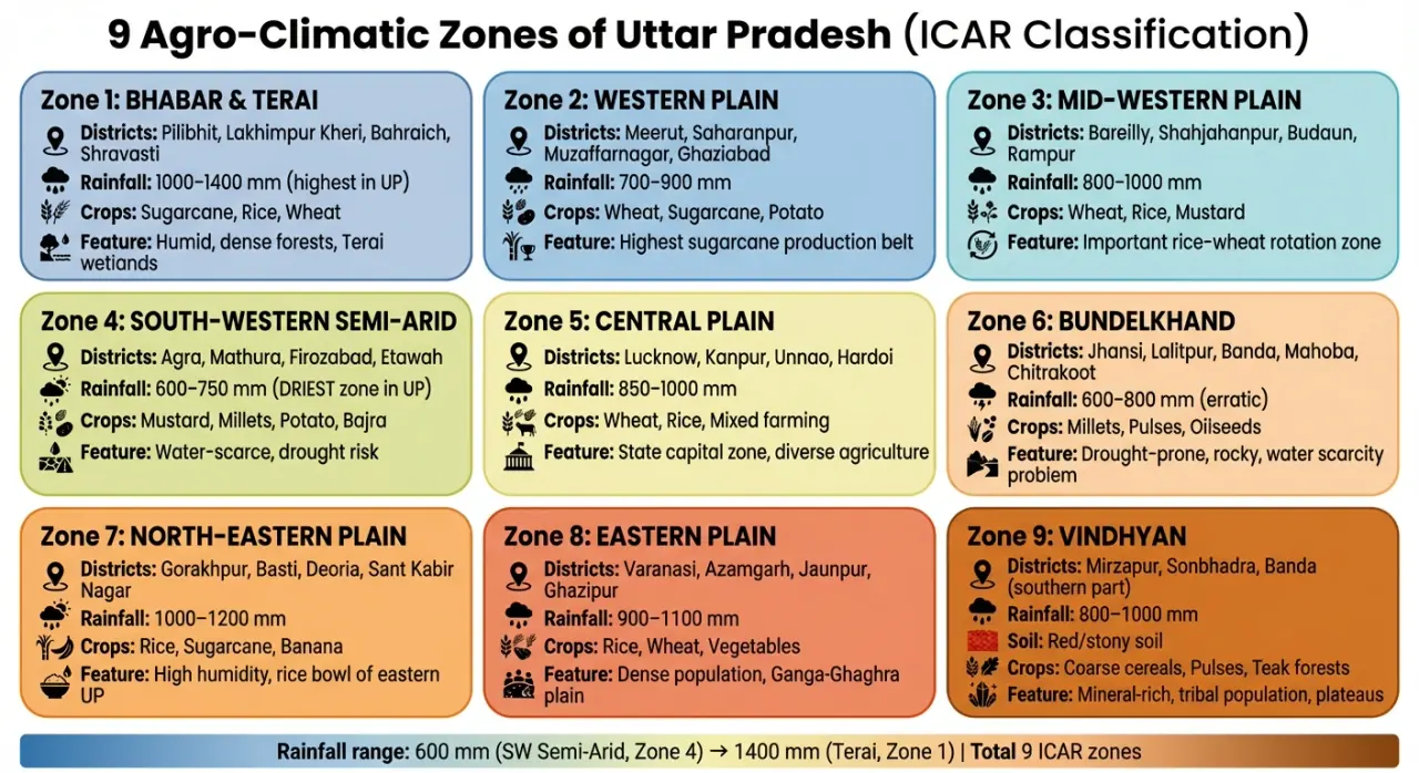
Zone-wise Detailed Table
| # | Zone Name | Key Districts | Annual Rainfall | Soil Type | Major Crops |
|---|---|---|---|---|---|
| 1 | Bhabar & Terai | Pilibhit, Lakhimpur Kheri, Bahraich, Shravasti | 1,000-1,400 mm | Alluvial, marshy, loamy | Sugarcane, rice, wheat, lentil |
| 2 | Western Plain | Meerut, Bulandshahr, Muzaffarnagar, Saharanpur, Shamli | 700-900 mm | Alluvial (Khadar & Bangar) | Wheat, sugarcane, potato, vegetables |
| 3 | Mid-Western Plain | Bareilly, Shahjahanpur, Budaun, Rampur | 800-1,000 mm | Alluvial, sandy loam | Wheat, rice, mustard, sugarcane |
| 4 | South-Western Semi-Arid | Agra, Mathura, Aligarh, Etah, Mainpuri, Firozabad | 600-750 mm | Alluvial, sandy | Millets, mustard, gram, potato |
| 5 | Central Plain | Lucknow, Kanpur, Unnao, Hardoi, Sitapur, Lakhimpur | 850-1,000 mm | Alluvial, loamy | Wheat, rice, sugarcane, pulses |
| 6 | Bundelkhand | Jhansi, Lalitpur, Hamirpur, Banda, Mahoba, Chitrakoot, Jalaun | 600-800 mm (erratic) | Red-laterite, rocky, shallow | Millets, pulses, oilseeds, gram |
| 7 | North-Eastern Plain | Gorakhpur, Basti, Siddharthnagar, Bahraich, Gonda | 1,000-1,200 mm | Alluvial, clayey | Rice, sugarcane, wheat, banana |
| 8 | Eastern Plain | Varanasi, Azamgarh, Jaunpur, Ghazipur, Ballia, Sultanpur | 900-1,100 mm | Alluvial, clay loam | Rice, wheat, oilseeds, vegetables |
| 9 | Vindhyan | Mirzapur, Sonbhadra, Prayagraj (part), Kaushambi | 800-1,000 mm | Red, stony, laterite | Coarse cereals, pulses, oilseeds |
This table should not be memorized as isolated rows. Instead, notice the pattern:
- Zones 1, 7, and 8 are relatively wetter and more rice-friendly.
- Zones 2, 3, and 5 are core alluvial plains with diversified, high-input farming.
- Zones 4, 6, and 9 face greater dryness, shallower soils, or plateau-type constraints.
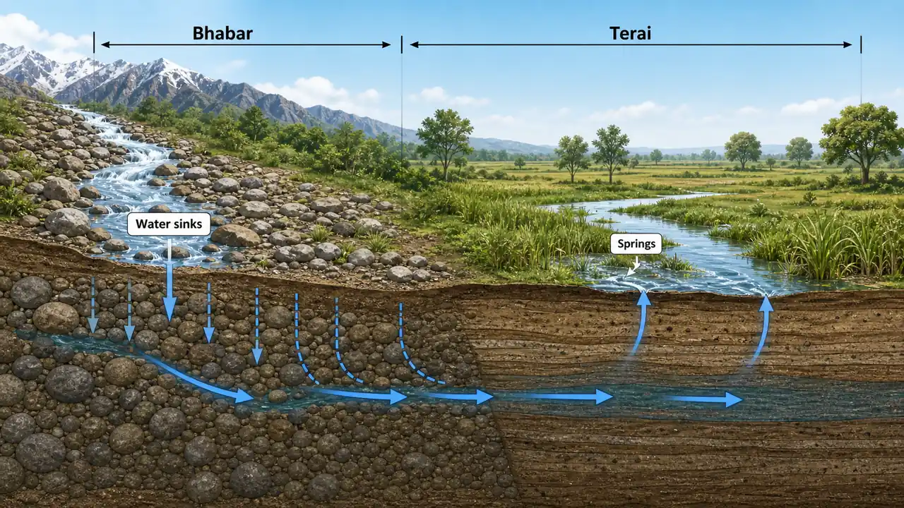
Zone 1: Bhabar and Terai
The northernmost zone along the Nepal border, this is a sub-humid to humid region with high rainfall and waterlogged conditions.
- Bhabar: Narrow pebbly strip at the foot of Shivalik hills — porous soil, poor water retention
- Terai: Low-lying marshy belt south of Bhabar — fertile alluvial soil, high water table
- Sugarcane thrives here; Lakhimpur Kheri is one of the state's most important sugarcane districts
- Forest cover is relatively high (Dudhwa National Park lies in this zone)
This zone is agriculturally strong because it combines high moisture availability with fertile soils, but waterlogging, flood-like conditions, and disease pressure can also create problems.
Zones 2, 3, and 5: The Main Alluvial Farming Belt
The Western Plain, Mid-Western Plain, and Central Plain together form the core alluvial farming belt of UP.
- Deep alluvial soils support intensive agriculture
- Irrigation, roads, mandis, and market access are relatively stronger here
- Wheat-sugarcane-potato systems are especially important in the west
- Mixed farming with wheat, rice, sugarcane, and pulses is common in the central belt
Exam-wise, these zones should be remembered as the state's highly developed plain-agriculture regions.
Zone 4: South-Western Semi-Arid
The driest zone in UP with rainfall as low as 600 mm. Classified as semi-arid.
- Soil is sandy and alkaline — requires careful irrigation management
- Mustard is the dominant oilseed; Agra-Mathura belt is a major mustard region
- Potato cultivation has expanded significantly in Agra and Firozabad
- Water scarcity is a persistent concern — depends heavily on canal and tube-well irrigation
This zone is important because it shows that even in the alluvial plain, rainfall deficiency changes the crop pattern. Compared with wetter eastern UP, this belt is relatively better for mustard, gram, and potato than for water-loving paddy.
Zone 6: Bundelkhand
The most drought-prone agro-climatic zone in UP and one of the most agriculturally stressed regions.
- Rocky and undulating terrain with shallow soil depth
- Rainfall is erratic — frequent drought years lead to crop failure
- Traditional crops: millets (bajra, jowar), gram, lentil, sesame
- Bundelkhand Package — special central government relief and development programme
- Outward migration is extremely high due to agrarian distress
- Potential for dryland horticulture: aonla (amla), guava, pomegranate
The key concept here is that the real problem is often not only low rainfall, but poor moisture retention, rocky terrain, runoff, and weak irrigation security.
Zone 7: North-Eastern Plain
This zone receives the highest rainfall after the Terai zone and is prone to annual flooding.
- Rice is the staple kharif crop; paddy fields dominate the landscape
- Sugarcane is widely grown; Gorakhpur has significant crushing capacity
- Flooding from rivers like Rapti, Ghaghra, and Gandak causes annual damage
- Dense settlement and repeated flood stress shape agriculture strongly
This zone is best remembered as a high-rainfall, flood-prone rice belt.
Zones 8 and 9: Eastern Plain and Vindhyan Contrast
These two zones are often confused, so keep the contrast clear:
- Zone 8 (Eastern Plain) is still a plain zone with alluvial soils, rice-wheat systems, and relatively denser settlement.
- Zone 9 (Vindhyan) moves toward plateau-like conditions with red, stony, and lateritic soils, where coarse cereals, pulses, and oilseeds become more important.
So, even though both lie toward the eastern/south-eastern side of the state, Zone 8 is a plain-farming zone, while Zone 9 is a plateau-influenced zone.
Comparison: Western vs Eastern UP Agriculture
| Parameter | Western UP (Zones 2-4) | Eastern UP (Zones 7-8) |
|---|---|---|
| Irrigation | Relatively higher coverage | Lower and more uneven coverage |
| Dominant crops | Wheat, sugarcane, potato | Rice, pulses |
| Productivity | Higher (above national average) | Lower |
| Farm income | Relatively better | Below state average |
| Mechanization | High (tractors, combines) | Low to moderate |
| Urbanization | Higher | Lower |
Summary Cheat Sheet
| Zone | Name | Key Feature |
|---|---|---|
| 1 | Bhabar & Terai | Sugarcane, highest rainfall, marshy |
| 2 | Western Plain | Wheat-sugarcane, intensive irrigation |
| 3 | Mid-Western Plain | Wheat, rice, mustard |
| 4 | South-Western Semi-Arid | Driest zone, mustard, potato |
| 5 | Central Plain | Lucknow-Kanpur, mixed farming |
| 6 | Bundelkhand | Drought-prone, pulses, millets |
| 7 | North-Eastern Plain | Rice, flooding, high rainfall |
| 8 | Eastern Plain | Rice-wheat, oilseeds |
| 9 | Vindhyan | Coarse cereals, red/stony soil |
Lesson Doubts
Ask questions, get expert answers