🧭 UP Bordering States and Nepal — Uttar Pradesh Neighbours, Districts and Map
A clear explanation of Uttar Pradesh's neighbouring states, Nepal border, key border districts, and the exam-focused geography facts that help students avoid common confusion.
Quick answer: Uttar Pradesh borders 9 states/UTs and Nepal. The neighbours are Uttarakhand, Himachal Pradesh, Haryana, Delhi, Rajasthan, Madhya Pradesh, Chhattisgarh, Jharkhand, Bihar, plus Nepal on the international side.
The Most Connected State
When students first see this topic, they usually memorize the list but forget the pattern. A better way is to see UP as a central hinge: Nepal to the north, Bihar to the east, Madhya Pradesh to the south, and a chain of western and north-western neighbours connecting it to the NCR and north India.
In standard UP GK material, Uttar Pradesh is commonly described as bordering the highest number of neighbouring states/UTs because it touches 8 states, 1 Union Territory (Delhi), and Nepal internationally. It is also completely landlocked.
Exam Tip: In exam language, answer this as: UP borders 8 states + 1 UT + Nepal. That is the safest wording.
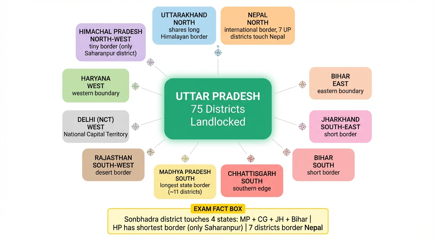
Neighbouring States & Union Territories
Here is the complete list of states and territories that share a boundary with UP, along with the general direction of the border:
| S.No. | Neighbour | Direction | Border Type |
|---|---|---|---|
| 1 | Uttarakhand | North | State |
| 2 | Himachal Pradesh | North-West (very small stretch) | State |
| 3 | Haryana | West / North-West | State |
| 4 | Delhi (NCT) | West / North-West | Union Territory |
| 5 | Rajasthan | West / South-West | State |
| 6 | Madhya Pradesh | South | State |
| 7 | Chhattisgarh | South-East (small stretch via Sonbhadra) | State |
| 8 | Jharkhand | South-East (small stretch via Sonbhadra) | State |
| 9 | Bihar | East | State |
| 10 | Nepal | North (international) | Country |
Memory Trick
To remember all 9 states + Nepal, use this mnemonic: "U Hi Ha R De Ra MP Ch Jh Bi Ne" — Uttarakhand, Himachal, Haryana, Rajasthan, Delhi, Madhya Pradesh, Chhattisgarh, Jharkhand, Bihar, Nepal.
Border Details by State
Instead of learning all borders equally, focus first on the borders that generate repeated exam questions: Himachal Pradesh, Madhya Pradesh, Nepal, and Sonbhadra.
Northern Border
Uttarakhand shares the main northern boundary with UP. Before 2000, the area of present-day Uttarakhand was part of undivided Uttar Pradesh, so this border has both present-day and historical importance.
Himachal Pradesh is important not because the border is large, but because it is tiny and easy to forget. In exam preparation, students are usually taught that this contact occurs at the north-western edge near Saharanpur.
Western Border
Haryana borders UP on the western side and links naturally with the upper-western districts such as Saharanpur, Shamli, Muzaffarnagar, Baghpat, Ghaziabad, and Gautam Buddha Nagar.
Delhi (NCT) touches UP through Ghaziabad and Gautam Buddha Nagar districts. The cities of Noida and Ghaziabad are essentially extensions of the Delhi metropolitan region.
Rajasthan shares the south-western side. In one-line exam memory, Rajasthan is usually associated with the Agra-Mathura side of UP.
Southern Border — Madhya Pradesh (Maximum Border Districts)
Madhya Pradesh shares the longest boundary with UP, touching approximately 11 UP districts — the most for any neighbouring state. These districts are spread across the Bundelkhand and Vindhyan regions:
| UP Districts Bordering MP |
|---|
| Agra, Etawah, Auraiya |
| Jalaun, Jhansi, Lalitpur |
| Hamirpur, Mahoba, Banda |
| Chitrakoot, Sonbhadra |
Exam Tip: MP borders the most UP districts (~11). This is tested as: "Which state shares the longest boundary with UP?" — Answer: Madhya Pradesh.
South-Eastern Border — Sonbhadra, the Gateway
Sonbhadra is one of the most geographically significant districts of UP. It is the only UP district that borders 4 states simultaneously — Madhya Pradesh, Chhattisgarh, Jharkhand, and Bihar.
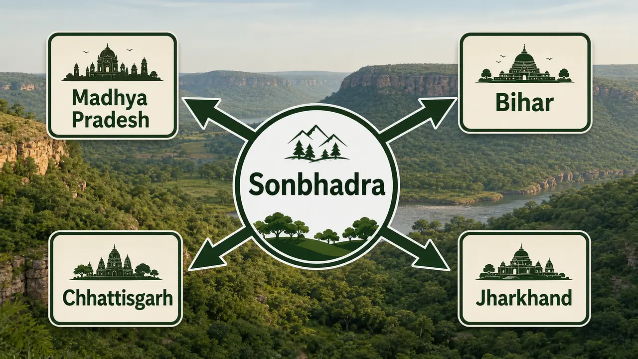
| State | Border via Sonbhadra |
|---|---|
| Madhya Pradesh | Southern edge |
| Chhattisgarh | South-eastern edge |
| Jharkhand | Eastern edge |
| Bihar | North-eastern edge |
This makes Sonbhadra a critical district for questions about inter-state boundaries. It also appears in other UP GK topics because of its mineral resources, tribal population, thermal-power belt, and low population density.
Eastern Border — Bihar
Bihar forms the major eastern neighbour of UP. In exam understanding, the eastern border should be connected with the Purvanchal belt, and the Ganga helps form the boundary in some stretches.
International Border — Nepal
UP shares an international border with Nepal along its northern edge. This is one of the most important border facts in the whole lesson because exams often ask for the count and names of these districts directly.
| UP Districts Bordering Nepal |
|---|
| Maharajganj |
| Siddharth Nagar |
| Balrampur |
| Shravasti |
| Bahraich |
| Lakhimpur Kheri |
| Pilibhit |
That is 7 UP districts sharing the Nepal border. These districts belong largely to the Terai belt, which explains why the Nepal-border topic is closely linked with forests, wetlands, grasslands, and wildlife in later lessons.
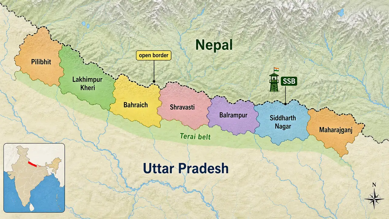
This border is also different from India's more tightly fenced borders elsewhere. For exam purposes, remember two linked facts:
- the Indo-Nepal border is traditionally treated as an open border
- the force associated with this border is the SSB
Sashastra Seema Bal (SSB)
The SSB (Sashastra Seema Bal) is the paramilitary force responsible for guarding the Indo-Nepal border. This is different from the BSF (which guards India-Pakistan and India-Bangladesh borders).
Strategic Significance
- UP's central location makes it a transportation hub connecting northern, eastern, and central India
- The National Capital Region (NCR) extends into Ghaziabad, Gautam Buddha Nagar, Bulandshahr, Hapur, and Meerut districts
- The Nepal border districts are significant for cross-border trade, pilgrimage routes (Lumbini is just across the border), and security concerns
- The Bundelkhand region (bordering MP) is historically underdeveloped and a focus of government schemes
Summary Cheat Sheet
| Item | Quick Fact |
|---|---|
| Total Neighbours | 8 states + 1 UT + Nepal |
| Most Border Districts With | Madhya Pradesh (~11 districts) |
| Touches 4 States | Sonbhadra |
| Tiny Border Reminder | Himachal Pradesh is the easiest neighbour to forget |
| Nepal Border Districts | 7 (Maharajganj to Pilibhit) |
| Delhi Border Via | Ghaziabad, Gautam Buddha Nagar |
| Border Force (Nepal) | SSB (Sashastra Seema Bal) |
| Coastline | None (landlocked) |
| NCR Districts in UP | Ghaziabad, G.B. Nagar, Bulandshahr, Hapur, Meerut |
Lesson Doubts
Ask questions, get expert answers