🐛 Soil Profile: Horizons & Their Characteristics
Master horizons (O, A, E, B, C, R), transitional horizons, pedon, polypedon, and diagnostic features of each soil layer
What is a Soil Profile?
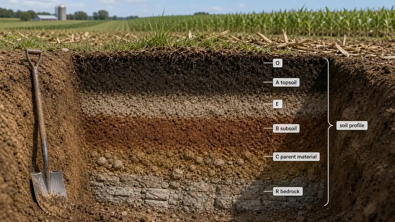
- Contains three main horizons: A (topsoil), B (subsoil), and C (parent material)
- A hypothetical complete profile includes: O, A, E, B, C and R master horizons
- The profile is a historic record of all soil forming processes
- It forms the basis for soil classification and practical land use decisions
| Horizon | Name | Key Process | Agricultural Significance |
|---|---|---|---|
| A | Topsoil (Eluviation zone) | OM accumulation; loss of clay, Fe, Al | Most important for crop production |
| B | Subsoil (Illuviation zone) | Accumulation of clay, Fe, Al from above | Root exploration zone; nutrient storage |
| C | Parent material | Minimal soil formation | Source material for soil development |
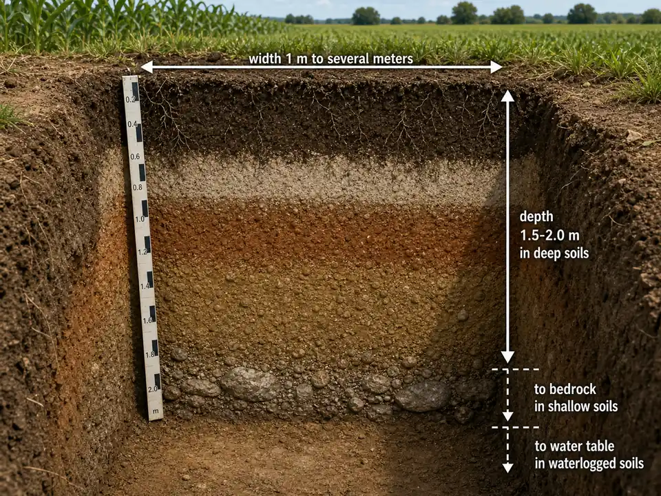
Profile Dimensions
| Parameter | Measurement |
|---|---|
| Depth | 1.5 to 2.0 meters in deep soils; up to bedrock in shallow soils; up to water table in waterlogged soils |
| Width | 1 meter to several meters |
Master Horizons
Capital letters represent master horizons. Originally six (O, A, E, B, C, R); later Soil Survey Staff added L, M and W.
Pro Content Locked
Upgrade to Pro to access this lesson and all other premium content.
Charged once for one year · ₹1188 total
Save ₹100/month vs ₹2388/year launch price
- All Agriculture & Banking Courses
- AI Lesson Questions (100/day)
- AI Doubt Solver (50/day)
- Glows & Grows Feedback (30/day)
- AI Section Quiz (20/day)
- 22-Language Translation (100/day)
- Recall Questions (20/day)
- AI Quiz (15/day)
- AI Quiz Paper Analysis (100/day)
- AI Step-by-Step Explanations (100/day)
- Spaced Repetition Recall (FSRS)
- AI Tutor
- Immersive Text Questions
- Audio Lessons — Hindi & English
- Mock Tests & Previous Year Papers
- Summary & Mind Maps
- XP, Levels, Leaderboard & Badges
- Generate New Classrooms
- Voice AI Teacher (AgriDots Live)
- AI Revision Assistant
- Knowledge Gap Analysis
- Interactive Revision (LangGraph)
🔒 Secure one-time yearly payment via Razorpay · No hidden fees
What is a Soil Profile?
- Contains three main horizons: A (topsoil), B (subsoil), and C (parent material)
- A hypothetical complete profile includes: O, A, E, B, C and R master horizons
- The profile is a historic record of all soil forming processes
- It forms the basis for soil classification and practical land use decisions
| Horizon | Name | Key Process | Agricultural Significance |
|---|---|---|---|
| A | Topsoil (Eluviation zone) | OM accumulation; loss of clay, Fe, Al | Most important for crop production |
| B | Subsoil (Illuviation zone) | Accumulation of clay, Fe, Al from above | Root exploration zone; nutrient storage |
| C | Parent material | Minimal soil formation | Source material for soil development |
Profile Dimensions
| Parameter | Measurement |
|---|---|
| Depth | 1.5 to 2.0 meters in deep soils; up to bedrock in shallow soils; up to water table in waterlogged soils |
| Width | 1 meter to several meters |
Master Horizons
Capital letters represent master horizons. Originally six (O, A, E, B, C, R); later Soil Survey Staff added L, M and W.
Let us examine each horizon from the surface downward, as a farmer would encounter them while digging.
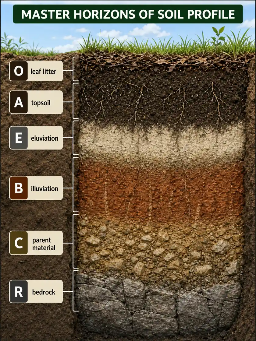
| Master Horizons Image Item | Full Content |
|---|---|
| O horizon | Organic surface layer made of fresh or partly decomposed plant and animal residues, common in forests and usually absent in cultivated fields |
| A horizon | Dark mineral topsoil where organic matter mixes with mineral material and most crop roots, microbes, and biological activity are concentrated |
| E horizon | Eluviation zone where clay, iron, aluminium, and some organic matter are washed out, making it lighter in colour |
| B horizon | Illuviation zone where materials leached from above, especially clay, iron, aluminium, or humus, accumulate in the subsoil |
| C horizon | Relatively unaltered unconsolidated parent material below the solum and outside the main zone of biological activity |
| R horizon | Hard consolidated bedrock lying below the weathered and unconsolidated soil material |
| Top to bottom pattern | The profile generally shifts from organic-rich and biologically active surface layers to less-weathered parent material and finally solid rock at depth |
O Horizon (Organic Horizon)
- Dominated by fresh or partly decomposed organic materials in the upper part of soil
- Visible in virgin (undisturbed) soil; absent in arable (cultivated) soils because ploughing mixes organic matter into the mineral soil
- Contains more than 30% organic matter if mineral fraction has >50% clay, or more than 20% organic matter if mineral fraction has less clay
- Commonly seen in forest areas; generally absent in grassland and cultivated soils
| Sub-horizon | Description | Agricultural Example |
|---|---|---|
| O1 | Original plant/animal residues recognizable by naked eye (litter layer) | Fallen leaves on forest floor |
| O2 | Original material not recognizable (advanced decomposition = humus) | Dark, crumbly material under leaf litter |
A Horizon (Topsoil)
The A horizon is the most important layer for agriculture because it has the highest concentration of organic matter and nutrients.
- Shows accumulation of organic matter closely mixed with mineral fraction
- Darker in colour than lower horizons due to organic matter
| Sub-horizon | Key Feature | Agricultural Significance |
|---|---|---|
| A1 | Topmost mineral horizon; humified OM + mineral fraction; darkest | Where seeds germinate; maximum biological activity |
| E / A2 | Maximum eluviation of clay, Fe, Al oxides and OM; lightest colour | Accumulates resistant minerals (quartz) |
| A3 | Transitional between A and B; more A-like | Sometimes absent |
TIP
The E horizon was earlier called A2. It got a separate letter "E" (for Eluviation) to distinguish its leaching character from A's organic matter accumulation.
E Horizon (Eluviation Horizon)
- Zone of maximum eluviation -- main feature is loss of silicate clay, iron and aluminium
- Lighter in colour than both A horizon above and B horizon below
- Differentiated from B by a colour of high value (lighter) or lower chroma, or both
Agricultural significance: A prominent E horizon indicates heavy leaching -- such soils may need frequent fertilization since nutrients are washed down.
B Horizon (Subsoil)
The zone of accumulation (illuviation) -- materials washed down from A and E horizons are deposited here.
- Dominant features: accumulation of clay, iron, aluminium or humus
- Sesquioxide coatings impart darker, stronger red colour than horizons above or below
- Called the zone of "washing in" or horizon of maximum accumulation
| Sub-horizon | Key Feature | Agricultural Significance |
|---|---|---|
| B1 | Transitional; more like A than B | Gradual change zone |
| B2 | Maximum accumulation of clay, Fe, Al oxides | May restrict drainage; root barrier if too dense |
| B3 | Transitional; more like B than C | Grades into parent material |
Agricultural significance: The B horizon is critical for subsoil drainage. A dense, clay-rich B2 horizon (called a "claypan") can cause waterlogging in the root zone above -- a common problem in rice-wheat rotation fields.
C Horizon (Parent Material)
- Unconsolidated material below the solum (A + B)
- Relatively less affected by soil forming processes
- Outside the zone of major biological activity
- May contain accumulations of carbonates, sulphates, calcium and magnesium
Agricultural significance: The C horizon determines the reserve of nutrients available for long-term soil fertility. Soils with nutrient-rich C horizons (e.g., from basalt) are inherently more sustainable than those from nutrient-poor parent materials (e.g., from sandstone).
R Horizon (Bedrock)
- Underlying consolidated bedrock
- Hard, continuous rock that cannot be dug with a spade
- May or may not be like the parent rock from which the solum formed
- Examples: granite, basalt, quartzite, limestone, sandstone
Agricultural significance: Depth to R horizon determines the effective rooting depth. Shallow soils with R horizon close to surface limit crop choice to shallow-rooted species.
Horizons at a Glance
| Horizon | Type | Key Feature | Colour | Agriculture |
|---|---|---|---|---|
| O | Organic | Fresh/decomposed OM; >20-30% OM | Very dark | Forest soils; absent in cropland |
| A (A1) | Mineral | Topsoil; OM accumulation | Darkest mineral horizon | Primary root zone; seedbed |
| E (A2) | Mineral | Maximum eluviation; loss of clay, Fe, Al | Lightest | Indicates heavy leaching |
| B | Mineral | Subsoil; illuviation; clay, Fe, Al accumulation | Reddish/brown | Subsoil drainage; nutrient storage |
| C | Parent material | Unconsolidated; below solum; least weathered | Variable | Nutrient reserve |
| R | Bedrock | Hard, consolidated rock | -- | Determines maximum rooting depth |
Transitional Horizons
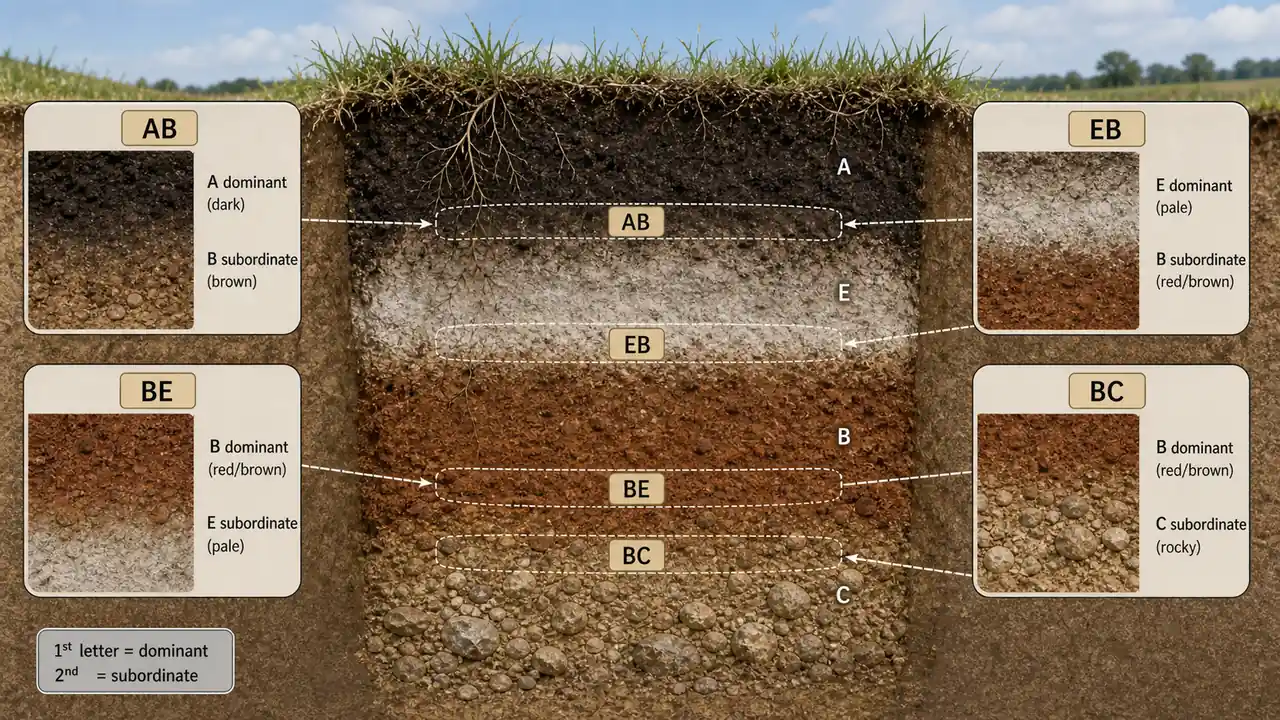
| Notation | Meaning | Example |
|---|---|---|
| AB | Mostly A properties, some B characteristics | Gradual transition from topsoil to subsoil |
| BC | Mostly B properties, grading into parent material | Common in moderately developed profiles |
Suffix Letters for Special Features
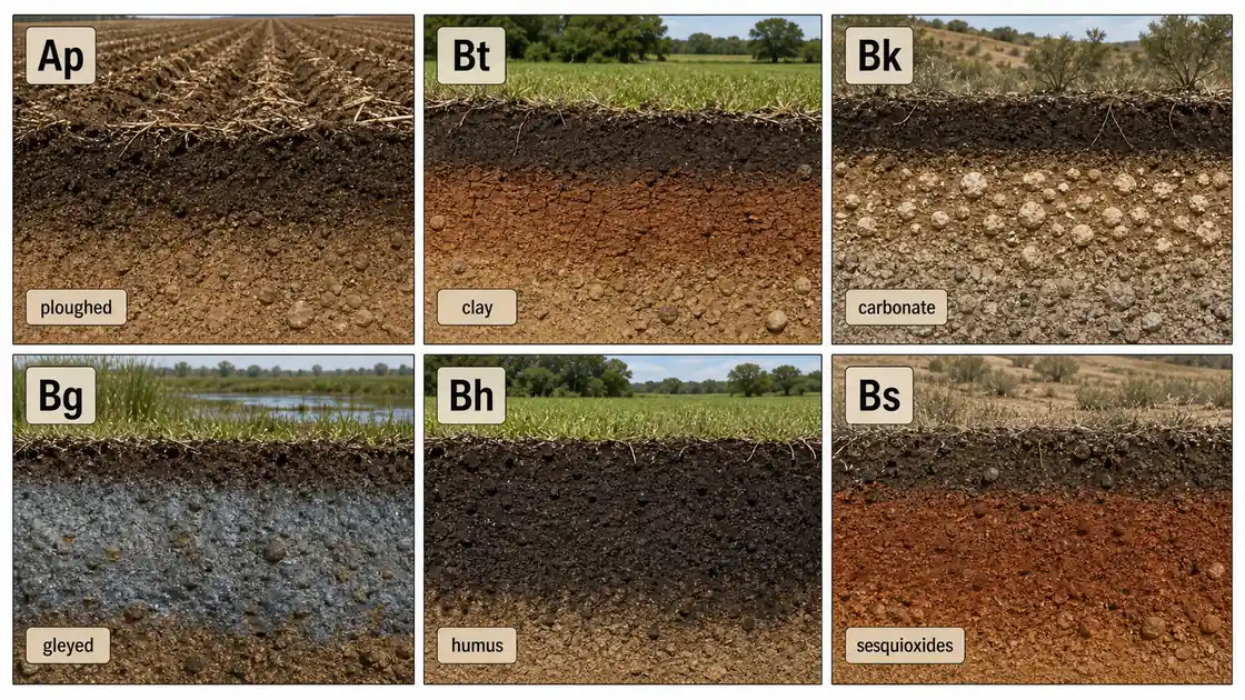
| Suffix | Meaning | Example | Agricultural Significance |
|---|---|---|---|
| p | Ploughed | Ap = ploughed topsoil | Tillage-affected layer |
| t | Clay accumulation (ton = clay) | Bt = illuvial clay horizon | May restrict drainage |
| k | Carbonate accumulation | Bk = calcic horizon (Kankar) | Lime-rich subsoil |
| g | Gleying (waterlogged) | Bg = gleyed B horizon | Poor drainage indicator |
| h | Humus accumulation | Bh = humus-enriched B | Common in podzols |
| s | Sesquioxide accumulation | Bs = Fe/Al oxide enriched | Red-coloured subsoil |
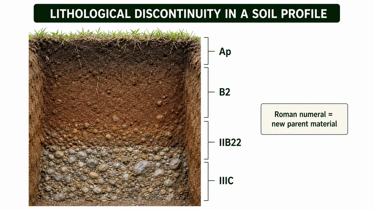
When genetically unrelated materials are present in a profile (as in alluvial soils), this lithological discontinuity is shown with Roman numeral prefixes: e.g., Ap, B2, IIB22, IIIC.
Pedon and Polypedon
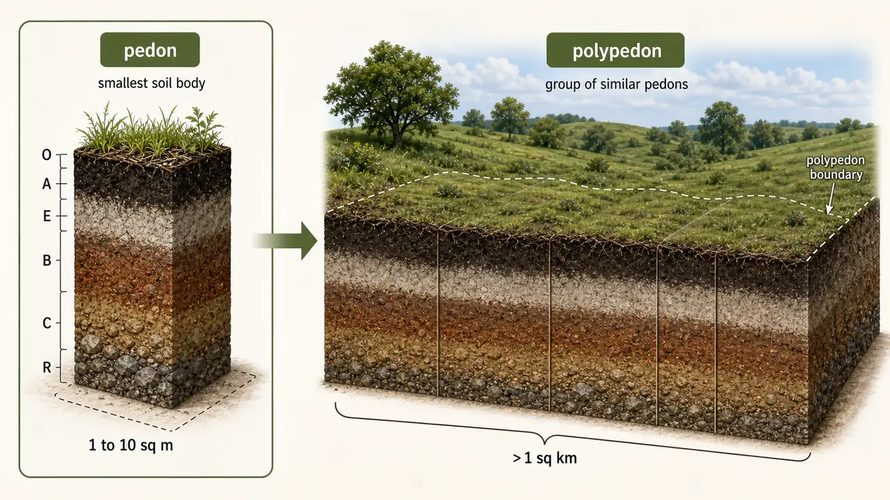
| Term | Definition | Size |
|---|---|---|
| Pedon | Smallest volume that can be called "a soil" | Surface to parent material; 1 to 10 sq. meters lateral extent |
| Polypedon | Contiguous group of similar pedons | More than 1 sq. km minimum area |
- A polypedon is bounded on all sides by "not-soil" or by pedons of unlike character
- The set of pedons must fit within the range of one soil series
Regolith and Soil Types
| Term | Definition | Agricultural Significance |
|---|---|---|
| Regolith | Unconsolidated product of rock weathering; loose earth above bedrock | Raw material for soil formation |
| Regosol | Soil without definite horizons; developing from deep, soft deposits (sands, loess, drift) | Immature soil; limited fertility |
| Organic soil | At least 20% OM (low clay) or 30% OM (high clay) | Found in wetlands, bogs; high OM but often acidic |
| Mineral soil | Usually less than 20% OM | Vast majority of agricultural soils |
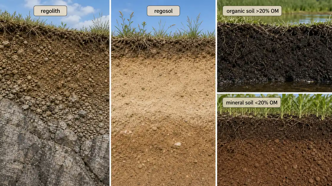
| Soil Type Threshold | Full Content |
|---|---|
| Regolith | Loose, unconsolidated weathered material above bedrock; raw material from which soil develops |
| Regosol | Immature soil with weak or no definite horizons, often formed in deep soft deposits such as sand, loess, or drift |
| Organic soil | Usually more than 20% organic matter when clay is low; threshold rises to 30% organic matter when clay content is high |
| Mineral soil | Usually less than 20% organic matter and forms the great majority of agricultural soils |
TIP
Remember the 20% threshold: <20% OM = mineral soils (most farmland); >20% OM = organic soils (wetlands). This threshold increases to 30% when clay content is high.
Summary Cheat Sheet
| Concept / Topic | Key Details |
|---|---|
| Soil profile | Vertical section showing layers from surface to parent material |
| Profile depth | 1.5–2.0 m in deep soils |
| 6 master horizons | O, A, E, B, C, R (+ L, M, W added later) |
| O horizon | Organic; >20–30% OM; absent in cultivated soils; present in forests |
| A horizon (A₁) | Topsoil; OM accumulation; darkest mineral horizon; most important for crops |
| E horizon (A₂) | Maximum eluviation; loss of clay, Fe, Al; lightest colour |
| B horizon | Illuviation zone; accumulation of clay, Fe, Al; "washing in" |
| Bt suffix | Clay accumulation (t = ton = clay in German) |
| Bk suffix | Carbonate (kankar) accumulation |
| Bg suffix | Gleying (waterlogged) |
| C horizon | Unconsolidated parent material; below solum; least weathered |
| R horizon | Hard consolidated bedrock; cannot be dug with spade |
| Solum | A + B horizons = true soil body |
| Transitional horizons | Two letters; first = dominant (e.g., AB, BC) |
| Ap suffix | Ploughed topsoil |
| Pedon | Smallest soil volume; 1–10 sq. m lateral extent |
| Polypedon | Contiguous similar pedons; >1 sq. km |
| Mineral soil | <20% OM — vast majority of agricultural soils |
| Organic soil | >20% OM (or >30% with high clay); wetlands, bogs |
| Regolith | Unconsolidated product of rock weathering; raw material for soil |
| Regosol | Soil without definite horizons; from deep soft deposits |
| Lithological discontinuity | Roman numeral prefix (e.g., IIB22, IIIC) |
| Bt horizon | Clay accumulation (t = ton = clay); Exam tip: Suffix notation |