🌊 Soil Erosion and Conservation: Protecting India's Farmland
Types of water and wind erosion, USLE equation, agronomic and engineering conservation practices, and watershed management for competitive exams
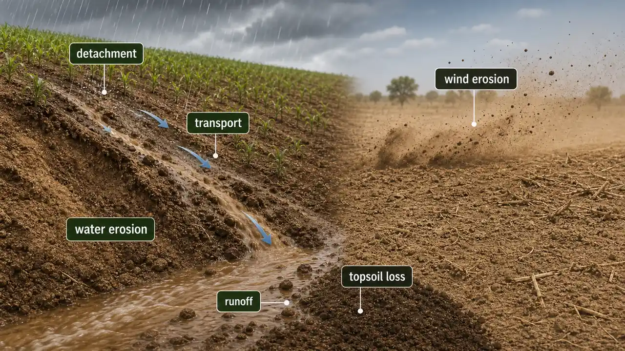
Every monsoon, India loses millions of tonnes of its most fertile topsoil. A farmer on a sloping field in Shivalik hills watches helplessly as rain washes away the dark, nutrient-rich surface soil, leaving behind infertile subsoil. Over time, his crop yields decline year after year. Soil erosion is not a distant problem -- it is happening right now on India's farmlands at a rate of 16.4 ton/ha/year, far exceeding the permissible limit of 12 ton/ha/year. Understanding erosion types and conservation methods is essential for every agriculture professional.
What is Soil Erosion?
| Key Term | Definition |
|---|---|
| Erosivity | The potential ability of rainfall to cause erosion (depends on rain intensity and drop size) |
| Erodibility | The vulnerability or susceptibility of the soil to be eroded (depends on soil properties) |
| Anthropogenic erosion | Erosion caused by human activities -- excessive grazing, deforestation, poor farming |
Key Facts About Soil Erosion in India
| Fact | Value |
|---|---|
| Permissible soil loss limit | 12 ton/ha/year |
| Present erosion rate | 16.4 ton/ha/year (exceeding the limit) |
| More susceptible to water erosion | Fine-textured soils |
| Erosion-resisting crops | Cowpea, Groundnut, Lobia, Grasses (dense ground cover) |
Types of Soil Erosion
| Type | Agent | Where it Dominates |
|---|---|---|
| Water erosion | Rainfall and runoff | Humid and sub-humid regions; sloping lands |
| Wind erosion | Wind force | Arid and semi-arid regions (Rajasthan, Gujarat) |
Water Erosion
Water erosion occurs in a progressive sequence of increasing severity:
Pro Content Locked
Upgrade to Pro to access this lesson and all other premium content.
₹99 charged monthly · Cancel anytime
- All Agriculture & Banking Courses
- AI Lesson Questions (100/day)
- AI Doubt Solver (50/day)
- Glows & Grows Feedback (30/day)
- AI Section Quiz (20/day)
- 22-Language Translation (100/day)
- Recall Questions (20/day)
- AI Quiz (15/day)
- AI Quiz Paper Analysis (100/day)
- AI Step-by-Step Explanations (100/day)
- Spaced Repetition Recall (FSRS)
- AI Tutor
- Immersive Text Questions
- Audio Lessons — Hindi & English
- Mock Tests & Previous Year Papers
- Summary & Mind Maps
- XP, Levels, Leaderboard & Badges
- Generate New Classrooms
- Voice AI Teacher (AgriDots Live)
- AI Revision Assistant
- Knowledge Gap Analysis
- Interactive Revision (LangGraph)
🔒 Secure via Razorpay · Cancel anytime · No hidden fees
Every monsoon, India loses millions of tonnes of its most fertile topsoil. A farmer on a sloping field in Shivalik hills watches helplessly as rain washes away the dark, nutrient-rich surface soil, leaving behind infertile subsoil. Over time, his crop yields decline year after year. Soil erosion is not a distant problem -- it is happening right now on India's farmlands at a rate of 16.4 ton/ha/year, far exceeding the permissible limit of 12 ton/ha/year. Understanding erosion types and conservation methods is essential for every agriculture professional.
What is Soil Erosion?
| Key Term | Definition |
|---|---|
| Erosivity | The potential ability of rainfall to cause erosion (depends on rain intensity and drop size) |
| Erodibility | The vulnerability or susceptibility of the soil to be eroded (depends on soil properties) |
| Anthropogenic erosion | Erosion caused by human activities -- excessive grazing, deforestation, poor farming |
Key Facts About Soil Erosion in India
| Fact | Value |
|---|---|
| Permissible soil loss limit | 12 ton/ha/year |
| Present erosion rate | 16.4 ton/ha/year (exceeding the limit) |
| More susceptible to water erosion | Fine-textured soils |
| Erosion-resisting crops | Cowpea, Groundnut, Lobia, Grasses (dense ground cover) |
Types of Soil Erosion
| Type | Agent | Where it Dominates |
|---|---|---|
| Water erosion | Rainfall and runoff | Humid and sub-humid regions; sloping lands |
| Wind erosion | Wind force | Arid and semi-arid regions (Rajasthan, Gujarat) |
Water Erosion
Water erosion occurs in a progressive sequence of increasing severity:
Splash → Sheet → Rill → Gully
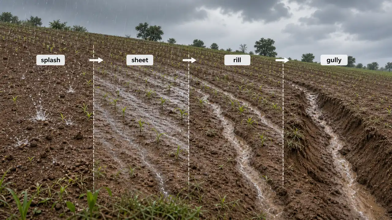
| Stage in Progression | What Happens | Exam Recall Cue |
|---|---|---|
| Splash erosion | Raindrop impact detaches soil particles from bare surface | First stage |
| Sheet erosion | Thin, uniform runoff removes a shallow layer of topsoil | Silent killer; mostly unnoticed |
| Rill erosion | Runoff concentrates into small channels across the field | Most common; tillage can fix it |
| Gully erosion | Rills deepen into large channels that normal tillage cannot repair | Most harmful; forms ravines |
1. Splash Erosion (Raindrop Erosion) -- The First Stage
| Feature | Detail |
|---|---|
| Stage | First stage of erosion |
| Mechanism | Kinetic energy of falling raindrops dislodges soil particles from bare surface |
| Displacement | Soil particles can be splashed up to 60 cm high and 1.5 m horizontally |
| Slope effect | On sloping land, more soil is splashed downhill than uphill |
Farm example: On a bare, freshly tilled field in the Deccan plateau, the first heavy monsoon rain splashes soil particles into the air -- this is the starting point of all water erosion.
2. Sheet Erosion -- The Silent Killer
| Feature | Detail |
|---|---|
| Definition | Uniform removal of soil layers from sloping land by thin sheets of water |
| Detection | Mostly goes unnoticed by farmers because removal is uniform |
| Damage | Extremely harmful -- removes the most nutrient-rich topsoil layer |
TIP
Sheet erosion is called the "silent killer" of soil fertility. By the time farmers notice declining yields, years of topsoil have already been lost.
Farm example: A wheat farmer in the Shivalik foothills loses 2-3 mm of topsoil every year to sheet erosion without realizing it. Over 10 years, this amounts to losing the entire fertile A-horizon.
3. Rill Erosion -- The Most Common Form
| Feature | Detail |
|---|---|
| Type | Most common form of water erosion |
| Mechanism | Runoff concentrates into small channels (rills) around vegetation patches |
| Position | Intermediate between sheet and gully erosion |
| Correction | Can be corrected by normal tillage operations |
Farm example: After heavy rain on a gently sloping groundnut field, small channels (5-10 cm deep) form between crop rows -- these are rills that can be smoothed out by the next ploughing.
4. Gully Erosion -- The Most Harmful Form
| Feature | Detail |
|---|---|
| Definition | Advanced stage of rill erosion; channels too deep for tillage to fix |
| Severity | Most spectacular, most noticeable, and most harmful form of water erosion |
| Result | Forms ravines -- deep, steep-sided channels that permanently damage agricultural land |
Classification of Gullies
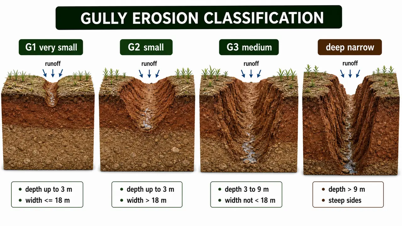
| Type | Depth (m) | Width (m) | Side Slope (%) |
|---|---|---|---|
| Very Small (G1) | Up to 3 | Not >18 | Varies |
| Small (G2) | Up to 3 | >18 | 8-15 |
| Medium (G3) | 3-9 | Not <18 | 8-15 |
| Deep and Narrow | >9 | Varies | Mostly steep |
IMPORTANT
Water erosion progression: Splash (first stage) → Sheet (goes unnoticed / silent killer) → Rill (most common / fixable by tillage) → Gully (most harmful / cannot be fixed by tillage). Remember: "S-S-R-G: Start Small, Run into Gullies"
Farm example: The Chambal ravines of Madhya Pradesh and Rajasthan are one of the worst examples of gully erosion in India -- thousands of hectares of once-productive land are now deep, unusable ravines.
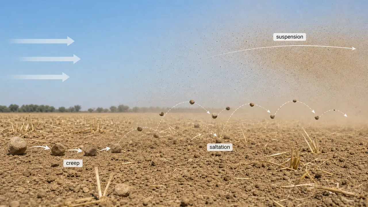
Wind Erosion
Wind erosion detaches and transports soil particles by wind force. It is predominant in arid and semi-arid regions where soil is dry, loose, and vegetation is sparse. Wind moves soil particles in three ways:
Three Modes of Wind Transport
| Mode | Particle Size | % of Total Soil Loss | Mechanism |
|---|---|---|---|
| Saltation | 0.1-0.5 mm | 50-75% (dominant) | Particles bounce/jump along the surface; strike surface at an angle, dislodging more particles |
| Surface Creep | >0.5 mm (large, heavy) | 5-25% | Particles roll/slide along surface, pushed by saltating particles |
| Suspension | <0.1 mm (very fine) | 3-4% | Fine particles float high in the air over thousands of km; cause dust storms |
TIP
Wind erosion transport: Saltation (50-75%) is the most dominant mode. By particle size (largest to smallest): Surface Creep (>0.5 mm) > Saltation (0.1-0.5 mm) > Suspension (<0.1 mm). Remember: "SaSuS -- Saltation is the Star"
Farm example: During dust storms in Rajasthan, the bulk of soil moves by saltation (bouncing), while the dramatic dust clouds visible from far away are caused by suspension of very fine particles.
Universal Soil Loss Equation (USLE)
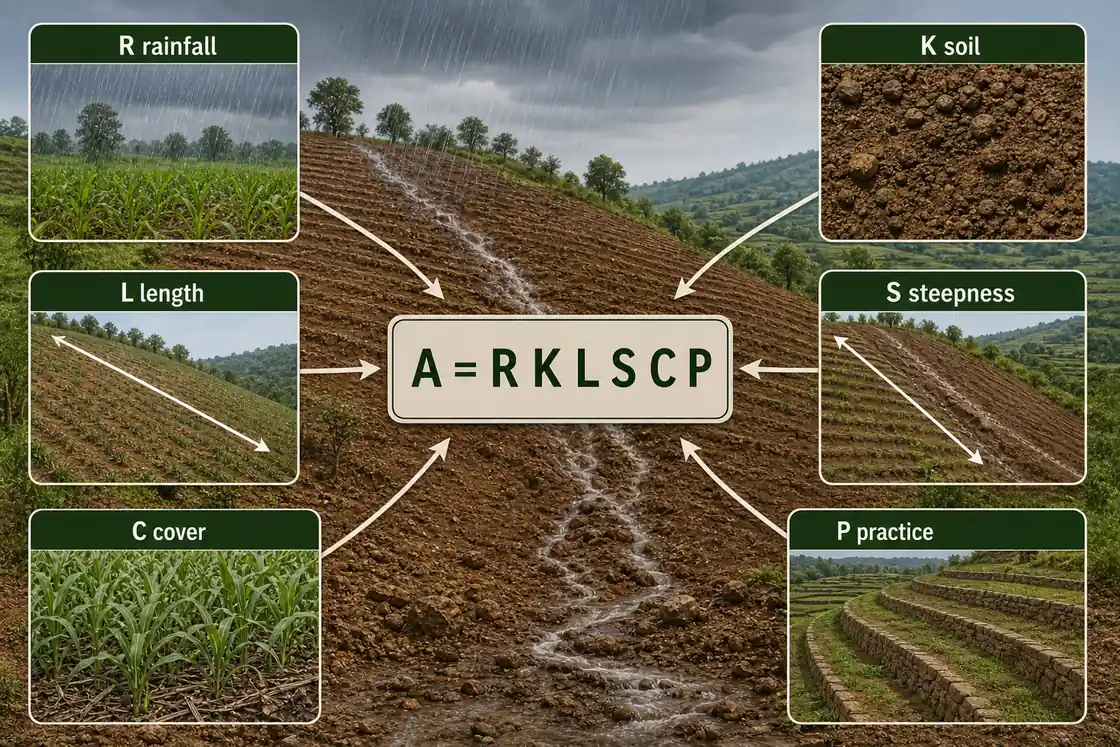
A = R x K x L x S x C x P
| Factor | Symbol | What it Represents | How to Remember |
|---|---|---|---|
| Average annual soil loss | A | Estimated soil loss (ton/ha/year) | Amount of loss |
| Rainfall erosivity | R | Erosive potential of rainfall and runoff | Rain power |
| Soil erodibility | K | Susceptibility of soil to erosion (texture, structure, OM, permeability) | Klay / soil factor |
| Slope length | L | Longer slopes = more erosion | Length of slope |
| Slope steepness | S | Steeper slopes = more erosion | Steepness |
| Crop management | C | Soil loss from cropped vs bare fallow (0 = no erosion; 1 = bare soil) | Crop cover |
| Conservation practice | P | Soil loss with practice vs no practice (0 = no erosion; 1 = no practice) | Practice factor |
IMPORTANT
USLE = A = RKLSCP is a very frequently asked formula. Lower values of C and P mean better conservation. Remember: "Rain Kills Land; Save Crops by Practice" (R-K-L-S-C-P).
Farm example: A soil scientist uses USLE to compare erosion on a bare fallow field (C=1, P=1) versus the same field with contour strip cropping of groundnut and grass (C=0.3, P=0.5). The conservation practice reduces predicted erosion by 85%.
Soil Conservation Practices
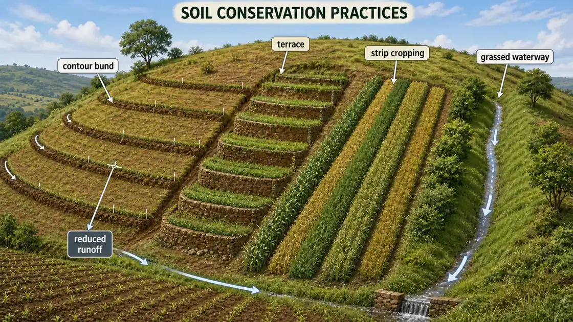
| Practice Shown in Image | Main Role in Erosion Control | Where It Fits |
|---|---|---|
| Contour bund | Slows runoff and stores water temporarily behind earthen embankments | Low-rainfall slopes up to 6% |
| Terrace | Breaks a long slope into step-like sections, reducing runoff velocity | Hill slopes and steeper cultivated land |
| Strip cropping | Alternates erosion-permitting and erosion-resisting strips to trap sediment | Sloping fields under row crops |
| Grassed waterway | Safely carries excess runoff without cutting the soil surface | Natural drainage lines and terrace outlets |
Conservation practices are classified into agronomic (vegetative) and engineering (mechanical) measures.
Agronomic / Vegetative Measures
1. Contour Farming
| Feature | Detail |
|---|---|
| Method | All farming operations done along the contour (across the slope) |
| Mechanism | Creates small ridges that act as barriers, reducing runoff velocity |
| Effective on | Slopes up to 8-10% |
Farm example: Soybean farmers in Malwa plateau (MP) plough and sow along contour lines to reduce soil loss during monsoon rains.
2. Strip Cropping
| Feature | Detail |
|---|---|
| Method | Alternate strips of erosion-permitting crops (row crops) and erosion-resisting crops (grasses, legumes) along the contour |
| Mechanism | Close-growing strips trap sediment from row-crop strips above |
| Types | Contour strip, Field strip, Buffer strip, Wind strip |
Farm example: On sloping lands of Jharkhand, farmers alternate strips of maize (erosion-permitting) with strips of stylo grass (erosion-resisting) to trap soil.
3. Cover Crops and Mulching
| Feature | Detail |
|---|---|
| Cover crops | Legumes and grasses protect soil surface during fallow periods |
| Mulching | Layer of crop residues, straw, or polythene on soil surface |
| Benefits | Reduces splash erosion, conserves moisture, moderates temperature, suppresses weeds |
Farm example: Sugarcane farmers in Maharashtra use trash mulching (dry sugarcane leaves) to protect soil between rows from splash erosion.
4. Crop Rotation
Including legumes and grasses in rotation maintains soil structure and organic matter, reducing erosion susceptibility.
5. Windbreaks and Shelterbelts
| Feature | Detail |
|---|---|
| Windbreaks | Single or few rows of trees perpendicular to wind to reduce wind velocity |
| Shelterbelts | Wider plantations (multiple rows) serving the same purpose on a larger scale |
| Protection range | 10-20 times the height of the trees on the leeward side |
Farm example: In the arid zone of Rajasthan, rows of Prosopis and neem trees are planted as shelterbelts to protect millet and mustard fields from wind erosion.
Engineering / Mechanical Measures
1. Terracing
| Feature | Detail |
|---|---|
| Method | Step-like structures across the slope to break slope length |
| Mechanism | Reduces runoff velocity; provides time for infiltration |
| Types | Bench terrace, Broad-base, Narrow-base, Graded, Level |
Farm example: The rice terraces of Nagaland and Meghalaya are classic examples of bench terracing that have sustained hill agriculture for centuries.
2. Contour Bunding
| Feature | Detail |
|---|---|
| Method | Earthen embankments (bunds) along the contour |
| Suitable for | Low-rainfall areas (<600 mm); slopes up to 6% |
| Mechanism | Impounds water behind bunds, reducing runoff and promoting infiltration |
3. Grassed Waterways
Natural or constructed channels planted with grass to safely convey runoff without causing erosion. They serve as outlets for terraces and contour bunds.
4. Check Dams
Small temporary or permanent dams across gullies to reduce water velocity and trap sediment. Help in gully reclamation and groundwater recharge.
Farm example: In the Chambal ravines, series of check dams have been constructed to slow water flow, trap sediment, and gradually reclaim gullied land for agriculture.
Watershed Management
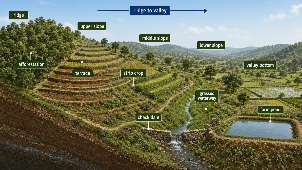
| Landscape Position in Image | Treatment Shown | Purpose |
|---|---|---|
| Ridge / hilltop | Afforestation | Stabilizes soil and reduces rapid runoff generation |
| Upper slope | Terracing | Shortens slope length and improves infiltration |
| Middle slope | Strip cropping and grassed waterway | Traps sediment and safely drains runoff |
| Lower slope | Check dam | Slows flow, traps sediment, and helps gully reclamation |
| Valley bottom | Farm pond | Stores runoff water for later use and recharge |
A watershed is a geohydrological unit draining to a common point. All land drains to one watershed or another. It is bounded by a drainage divide with a single outlet for surface runoff.
Types of Watersheds
| Type | Area |
|---|---|
| Macro watershed | >50,000 hectares |
| Sub-watershed | 10,000-50,000 hectares |
| Milli-watershed | 1,000-10,000 hectares |
| Micro watershed | 100-1,000 hectares |
| Mini watershed | 1-100 hectares |
Objectives of Watershed Management
| Objective | How it Helps Agriculture |
|---|---|
| Soil conservation | Prevents erosion, maintains productivity |
| Water conservation | Maximizes infiltration, minimizes runoff |
| Flood control | Reduces peak runoff rates |
| Groundwater recharge | Increases well water for irrigation |
| Sediment control | Reduces reservoir siltation |
| Sustainable land use | Optimizes land use based on capability |
Integrated Watershed Management Approach
Treatments are applied from ridge to valley (top-down approach):
| Location | Conservation Measure |
|---|---|
| Ridge/Hilltop | Afforestation, contour bunding |
| Upper slope | Terracing, cover crops |
| Middle slope | Strip cropping, grassed waterways |
| Lower slope | Check dams, gully plugging |
| Valley bottom | Farm ponds, water harvesting |
TIP
Watershed management follows a ridge-to-valley approach. Start from the hilltops and work downward. Remember: "Ridge → Terrace → Strip → Check → Pond"
Farm example: The watershed development programme in Ralegan Siddhi (Maharashtra) transformed a drought-prone village by implementing ridge-to-valley conservation measures, increasing groundwater levels and crop yields dramatically.
Exam Tips and Mnemonics
- Permissible soil loss in India: 12 ton/ha/year; present rate: 16.4 ton/ha/year
- Water erosion sequence: "S-S-R-G" -- Splash (first) → Sheet (unnoticed) → Rill (most common) → Gully (most harmful)
- Rill vs Gully: Rill can be fixed by tillage; Gully cannot
- Wind erosion dominant mode: Saltation (50-75%)
- USLE: A = RKLSCP -- "Rain Kills Land; Save Crops by Practice"
- USLE developers: Wischmeier and Smith, 1965
- Windbreak protection: 10-20 times tree height on leeward side
- Contour bunding: For slopes up to 6%, rainfall <600 mm
- Contour farming: For slopes up to 8-10%
- Watershed approach: Ridge-to-valley (top-down)
- Erosion-resisting crops: Cowpea, Groundnut, Lobia, Grasses -- "CGLG cover the Ground"
- Sheet erosion = "Silent killer" -- uniform, unnoticed
- Gully erosion = "Most spectacular" -- ravines, permanent damage
Summary Cheat Sheet
| Concept / Topic | Key Details / Explanation |
|---|---|
| Soil erosion | Detachment and transportation of soil by water, wind, ice, or gravity |
| Erosivity | Potential of rainfall to cause erosion (depends on intensity and drop size) |
| Erodibility | Susceptibility of soil to be eroded |
| Permissible soil loss (India) | 12 ton/ha/year |
| Present erosion rate (India) | 16.4 ton/ha/year (exceeds permissible limit) |
| Water erosion sequence | Splash → Sheet → Rill → Gully ("S-S-R-G") |
| Splash erosion | First stage; kinetic energy of raindrops dislodges particles; splash up to 60 cm high, 1.5 m horizontal |
| Sheet erosion | Uniform removal of soil layers; goes unnoticed ("silent killer") |
| Rill erosion | Most common form; small channels; can be corrected by tillage |
| Gully erosion | Most harmful / most spectacular; forms ravines; cannot be fixed by tillage |
| Gully example | Chambal ravines (MP and Rajasthan) |
| Wind erosion — Saltation | 0.1–0.5 mm particles; 50–75% of soil loss (dominant mode); bounce/jump |
| Wind erosion — Surface Creep | >0.5 mm; 5–25%; particles roll/slide |
| Wind erosion — Suspension | <0.1 mm; 3–4%; float high in air; cause dust storms |
| USLE formula | A = R × K × L × S × C × P |
| USLE — developed by | Wischmeier and Smith (1965) |
| USLE — A | Average annual soil loss (ton/ha/year) |
| USLE — R | Rainfall erosivity |
| USLE — K | Soil erodibility |
| USLE — L | Slope length |
| USLE — S | Slope steepness |
| USLE — C | Crop management (0 = no erosion; 1 = bare soil) |
| USLE — P | Conservation practice factor |
| USLE mnemonic | "Rain Kills Land; Save Crops by Practice" |
| Contour farming | All operations along contour; effective on slopes up to 8–10% |
| Strip cropping | Alternate strips of erosion-permitting + erosion-resisting crops |
| Windbreaks | Single/few rows of trees; protect 10–20 times tree height on leeward side |
| Shelterbelts | Wider windbreaks (multiple rows) |
| Terracing | Step-like structures across slope; reduces runoff velocity |
| Contour bunding | Earthen embankments along contour; slopes <6%; rainfall <600 mm |
| Check dams | Slow water velocity in gullies; trap sediment; aid groundwater recharge |
| Erosion-resisting crops | Cowpea, Groundnut, Lobia, Grasses |
| Macro watershed | >50,000 ha |
| Micro watershed | 100–1,000 ha |
| Watershed management approach | Ridge-to-valley (top-down): Afforestation → Terracing → Strip cropping → Check dams → Farm ponds |
| Goes unnoticed | Sheet erosion |
| Rills corrected by | Normal tillage |
| Gullies corrected by | Engineering measures (NOT tillage) |
| Saltation (wind) | 50-75% of soil loss; particle size 0.1-0.5 mm |
| Surface creep (wind) | 5-25%; particle size >0.5 mm |
| Suspension (wind) | 3-4%; particle size <0.1 mm |
| Windbreak protection | 10-20 times tree height |
| Watershed approach | Ridge-to-valley |
References
- Suresh, R. 2012. Soil and Water Conservation Engineering. Standard Publishers, New Delhi
- Das, D.K. 2011. Introductory Soil Science. Kalyani Publishers, Ludhiana
- Wischmeier, W.H. and Smith, D.D. 1978. Predicting Rainfall Erosion Losses. USDA Agriculture Handbook No. 537
- IARI Toppers. 2025. Soil Science Part-10. exams PDF Course
Lesson Doubts
Ask questions, get expert answers